Method for providing local mobile geographical information service based on GPS and mobile terminal

A geographic information service and mobile terminal technology, applied in the field of providing local mobile geographic information services based on GPS and mobile terminals, can solve the problem that there is no or significantly reduced mobile terminal interaction, and the real-time thin client mode cannot provide geographical space anytime and anywhere Position information services and other issues, to achieve the effect of no communication costs, easy promotion and application, and strong mobility

Inactive Publication Date: 2009-01-21
方圆信通科技(北京)有限公司
View PDF0 Cites 74 Cited by
  • Summary
  • Abstract
  • Description
  • Claims
  • Application Information

AI Technical Summary

Problems solved by technology

[0006] In view of this, the purpose of the present invention is to provide a method that can solve the above-mentioned defects of the prior art, provide local mobile geographic information services based on GPS and mobile terminals, the method is to use most of the services of GIS locally, that is, Realized on the mobile termina

Method used


Image

  • Method for providing local mobile geographical information service based on GPS and mobile terminal
  • Method for providing local mobile geographical information service based on GPS and mobile terminal
  • Method for providing local mobile geographical information service based on GPS and mobile terminal

Examples


Embodiment Construction

[0027] In order to make the object, technical solution and advantages of the present invention clearer, the present invention will be further described in detail below in conjunction with the accompanying drawings.

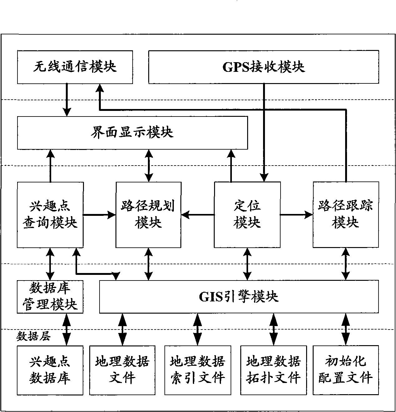
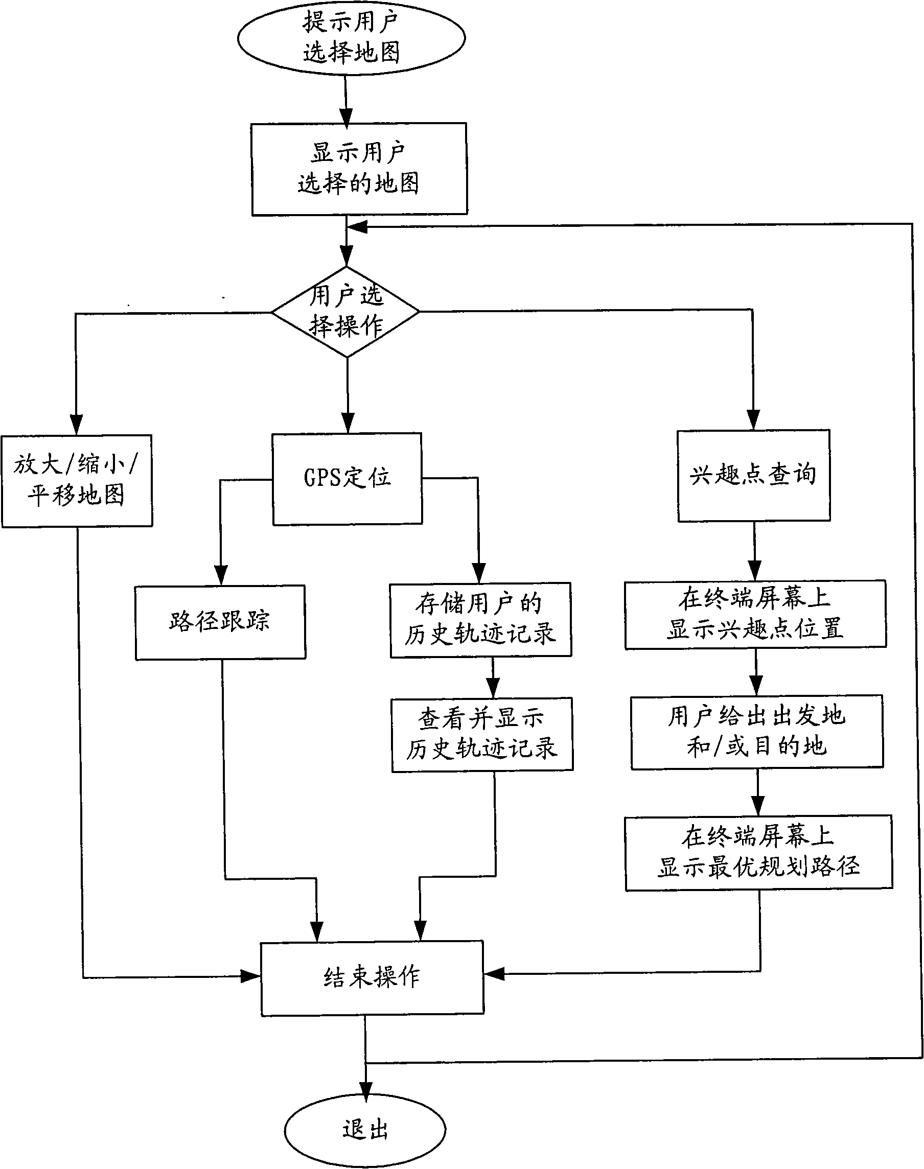
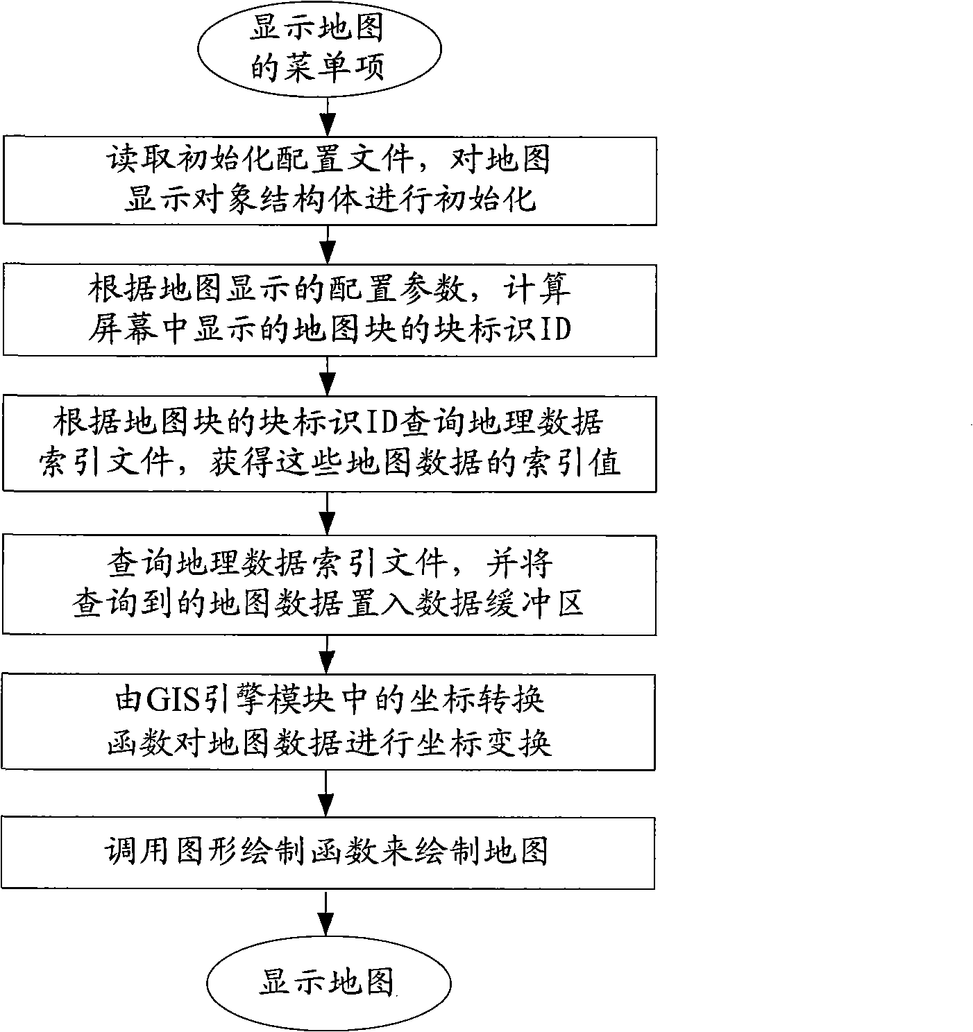
[0028] see figure 1 , introduces the implementation basis of the method for providing local mobile geographic information services based on GPS and mobile terminals in the present invention: a network system composed of wireless communication network, GPS positioning device and mobile terminal, Internet and path tracking server, wherein the communication network and related network Yuan refers to existing equipment, and mobile terminals include smart phones with Symbian, Windows Mobile, Linux or other operating systems, handheld personal computers, personal digital assistants PDA or mobile communication terminals with graphic input, processing and display functions; the innovative The key is to add multiple software function modules in the mobile terminal: wireles...


PUM


Abstract

A method for providing local mobile geographical information services based on the GPS and mobile terminals comprises firstly, prompting users to select maps, and conducting the map switch according to the selection of the users, and displaying the map on the screen of a mobile terminal, and continuing following one or a plurality of operation steps of local mobile geographical information services according to the subsequent selections of the users, such as translating or reducing or amplifying the map, self-positioning of the mobile terminal, monitoring and tracing path, inquiring interest points, searching the optimal path or exhibiting historical tracks. The method of the invention has simple and practicable operation step and low communication cost, and can realize various local mobile geographical position information services on the mobile terminal simply, real-timely and high effectively at any time and place. The invention has the advantages of strong mobility, small communication content, low cost, excellent practicability, high query efficiency and strong flexibility, which has great application and spread prospects.

Description

technical field [0001] The present invention relates to a method for providing geographic information services, to be more precise, relates to a method for providing local mobile geographic location information services (LBS, Location Based Service) using GPS and mobile terminals. Using the method of the present invention, it is possible to select and display , consulting various maps, performing panning and zooming processing on the maps, and realizing multiple functions such as self-positioning of mobile terminals, querying points of interest, navigation and path tracking, etc., which belong to the technical fields of telecommunication value-added services and computer applications. Background technique [0002] With the advent of the era of knowledge economy, information has become the source of wealth for human society. At present, more than 80% of the information in people's production and life is related to geographic spatial location. The rapid development and wide a...

Claims


Application Information

Patent Timeline
IPC IPC(8): G01C21/26G01C21/34G09B29/00G09B29/10
Inventor 谢东亮陈正东佟双熊鹏李建林吴金宇王璐
Owner 方圆信通科技(北京)有限公司
Why Eureka
Try Eureka