Land-utilization modification investigation method and system based on the combination of PDA and 3S

A land and historical land technology, applied in the direction of re-radiation, radio wave measurement system, electromagnetic wave re-radiation, etc., can solve problems such as unintegrated, positioning and navigation, land use space position and attribute synchronous real-time update, single function, etc. , to achieve the effect of overcoming the slow speed

Inactive Publication Date: 2009-06-03
BEIJING RES CENT FOR INFORMATION TECH & AGRI
View PDF0 Cites 20 Cited by
  • Summary
  • Abstract
  • Description
  • Claims
  • Application Information

AI Technical Summary

Problems solved by technology

For example, some methods combine GPS-RTK and PDA to realize positioning function, combine GIS and PDA to realize navigation function, etc., but these combination methods are too single, and PDA-based 3S technology integration is not realized
[0006] Therefore, at present, some methods that us

Method used


Image

  • Land-utilization modification investigation method and system based on the combination of PDA and 3S

Examples


Embodiment

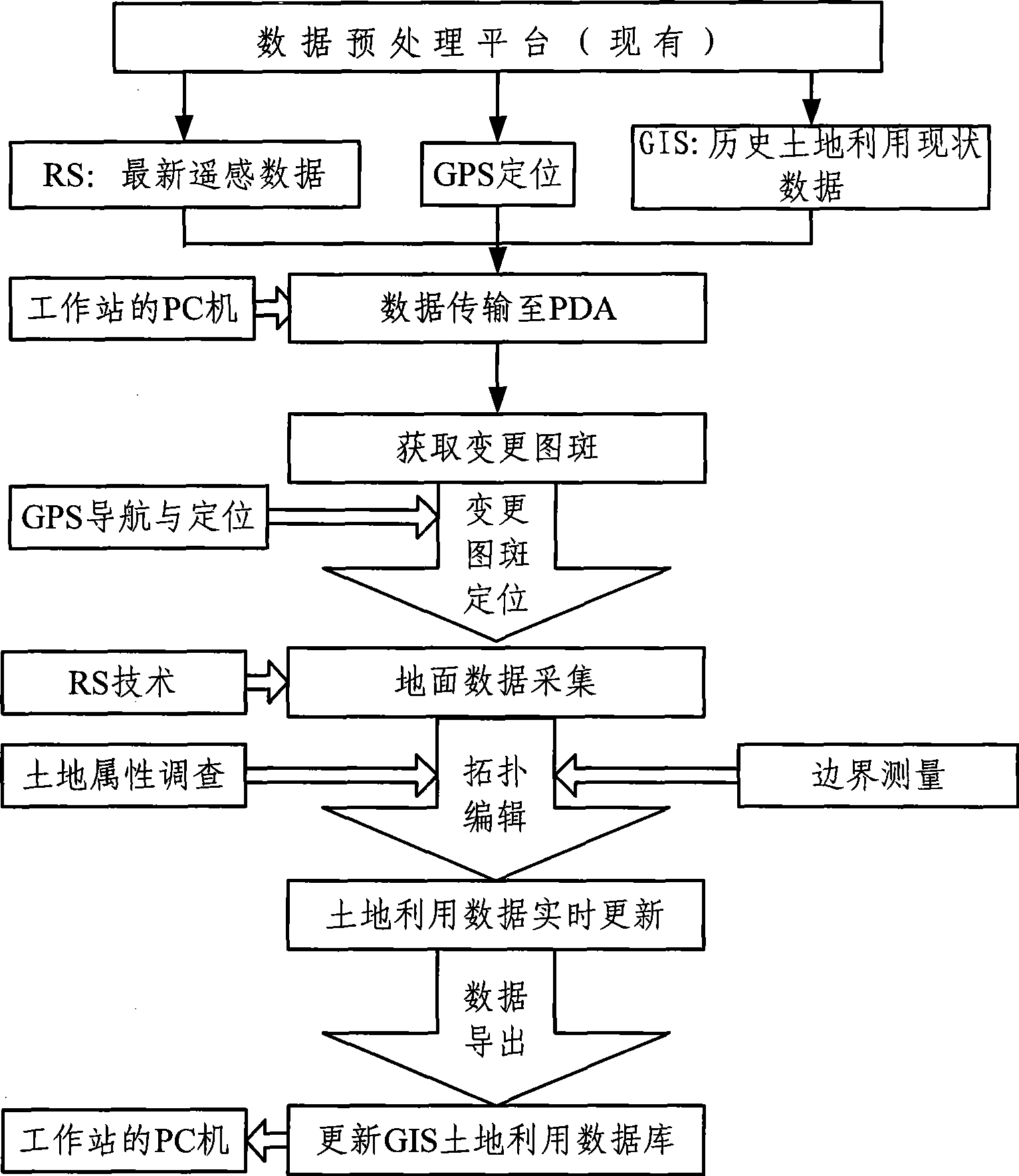
[0033] Such as figure 1 Shown is the flow chart of the land use change investigation method that the present invention combines based on PDA and 3S technology, and this method comprises the following steps:

[0034] 1) Obtain the historical land use status data through the land use status database of the GIS system in the PC, and obtain the latest phase remote sensing data and precise positioning data of the land through RS and GPS;

[0035] The historical land use status database mentioned here refers to the land use status data that has not been updated in real time after the land use change.

[0036] The data acquisition in the present embodiment step 1) is based on the data processing platform of the workstation, through which the GIS system can be accessed, the GIS system first obtains the attribute data, the orthophoto map and the land use data of the land, and then through the The superposition processing of these three data obtains the historical land use status data....


PUM


Abstract

The invention relates to a land-utilization modification investigation method and a system based on the combination of PDA and 3S. The comprehensive integration of GPS, GIS and RS is realized in a PDA environment; history land-utilization actuality data in GIS and remote sensing data acquired by RS are imported into PDA by utilizing the communication technology, and a modification delineation is obtained after segistration; modification delineation navigation, frontier surveying and area computation are carried out by utilizing GPS; then real-time editing is performed according to the delineation attribute obtained from the spot field investigation, to complete the update on the whole land-utilization actuality data; and the rapid update of system data in a land-utilization database in a GIS system is realized after office operation processing finally. The land-utilization modification investigation method and the system can rapidly and accurately complete field operation investigation in a high efficient manner, and overcome the disadvantages of low speed, long period, low accuracy, high cost and the like in a traditional land-utilization modification investigation method.

Description

technical field [0001] The invention relates to the field of land surveying, in particular to a land use change investigation method and system based on the combination of PDA and 3S. Background technique [0002] There are two main traditional land use change survey methods, one is to use the existing land use status map to compare in the field, use traditional measuring instruments such as tape measure and theodolite to measure the relevant position data, and draw the change on the land use status map Map spots; Another method is to use aerial survey photos to obtain changed map spot data through field mapping, and then carry out in-house drawing and processing. [0003] The method of using traditional surveying instruments combined with land use status maps to conduct land use change investigations is not only slow and inaccurate, but also increases the difficulty of measurement when the range of changes is large and the content of changes is large; Although the land use...

Claims


Application Information

Patent Timeline
IPC IPC(8): G06F17/30G06F19/00G01S17/89
Inventor 杨贵军黄文江李存军宋晓宇徐新刚王纪华赵春江顾晓鹤杨小冬陈红
Owner BEIJING RES CENT FOR INFORMATION TECH & AGRI
Why Eureka
Try Eureka