Navigation method and navigation apparatus using the same

A technology of a navigation device and a navigation method, applied in the field of navigation and a navigation device using the same, can solve the problems of inconvenience and not very extensive application of photo files, etc.

Inactive Publication Date: 2009-06-24
INVENTEC CORP
View PDF0 Cites 6 Cited by
  • Summary
  • Abstract
  • Description
  • Claims
  • Application Information

AI Technical Summary

Problems solved by technology

[0004] However, since different navigation devices attach the latitude and longitude to the photo file in different ways, a specific navigation device is

Method used


Image

  • Navigation method and navigation apparatus using the same
  • Navigation method and navigation apparatus using the same
  • Navigation method and navigation apparatus using the same

Examples


no. 1 example

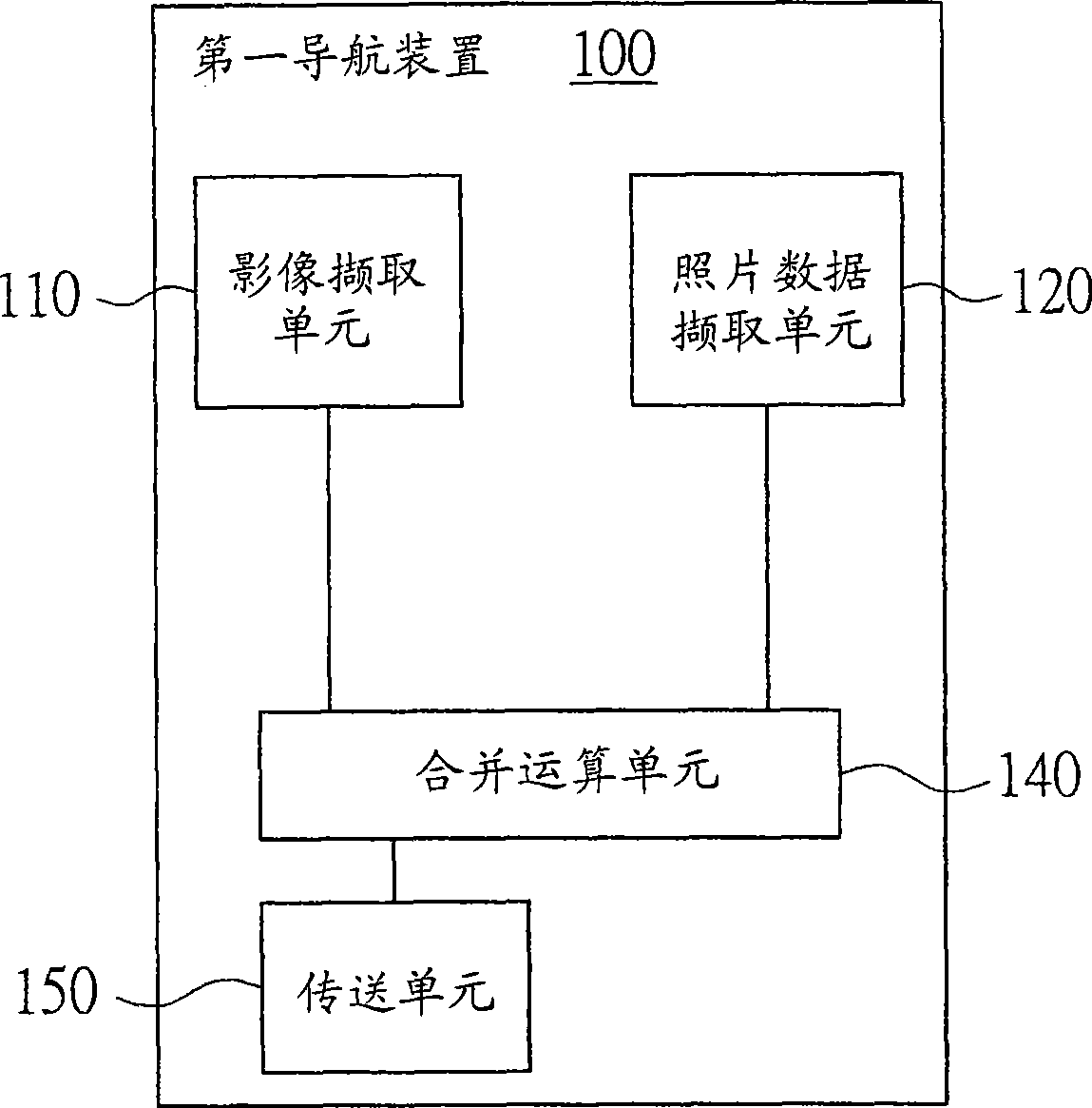
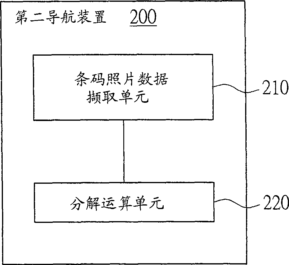
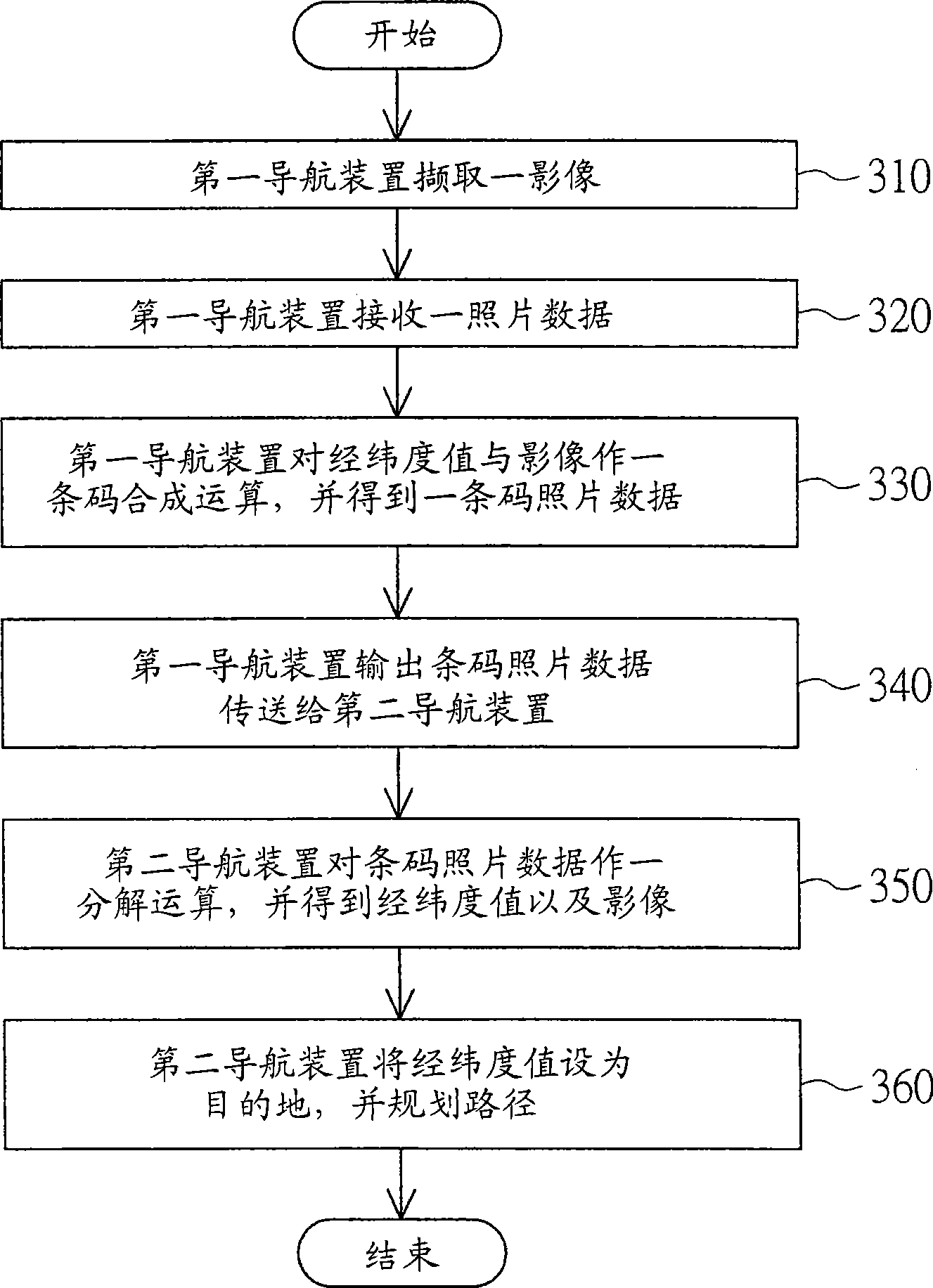
[0020] Please refer to figure 1 , which is a system block diagram of the first navigation device according to the first embodiment of the present invention. The first navigation device is, for example, a mobile phone, a PDA or a camera. In this embodiment, the first navigation device 100 is illustrated by taking a mobile phone as an example. The first navigation device 100 includes an image capturing unit 110 , a photo data receiving unit 120 , a synthesis operation unit 140 and a transmitting unit 150 . The image capture unit 110 is, for example, a built-in camera for capturing an image. The photo data receiving unit 120 is used for receiving a photo data, wherein the photo data includes a latitude and longitude value. The latitude and longitude values ​​are received by a global satellite positioning system (not shown) of the first navigation device 100 . The synthesis calculation unit 140 is used for performing a barcode synthesis operation on the latitude and longitude ...

no. 2 example

[0033] Please refer to Figure 5, which is a system block diagram of the first navigation device according to the second embodiment of the present invention. The navigation method of this embodiment and the first navigation device 400 using it are different from the navigation method of the first embodiment and the first navigation device 100 using it in that: the first navigation device 400 also includes a screen 410, the screen 410 is used for displaying images and two-dimensional barcodes.

[0034] Please refer to Figure 6A and Figure 6B . Figure 6A A system block diagram illustrating a navigation method of the second embodiment, Figure 6B A flow chart of the navigation method of the second embodiment is shown. The following collocation Figure 6A illustrate Figure 6B steps of flowchart. Since step 310 to step 330 in image 3 It has already been explained and will not be repeated here.

[0035] After step 330 , go to step 331 , where the first navigation devi...


PUM


Abstract

The invention provides a navigation method and a navigation device using the method, wherein, the navigation method which is applicable to a first navigation device and a second navigation device comprises the following steps: the first navigation device captures an image and receives a photo data, wherein, the photo data comprises a latitude and longitude value; the first navigation device carries out a bar code synthetic operation and obtains bar code photo data; the first navigation device transfers the bar code photo data to the second navigation device; the second navigation device carries out a decomposition operation to the bar code photo data and obtains the latitude and longitude value and the image; and the second navigation device sets the latitude and longitude value as a destination and plans a path.

Description

technical field [0001] The present invention relates to a navigation method and a navigation device using it, and in particular to a navigation method with barcode photo data and a navigation device using it. Background technique [0002] Global Positioning System (GPS) receiving devices have been widely used in the market. The satellite signal from space is received by the GPS receiving device, and then the longitude and latitude of the location of the GPS receiving device can be calculated with an algorithm. [0003] At present, some navigation devices on the market have a built-in camera device in addition to the built-in global satellite positioning system. After the navigation device takes pictures of the scenery of a region with the built-in camera device, the global satellite positioning system calculates the longitude and latitude of the location according to the received satellite signals, and then attaches the longitude and latitude to the photo file. In this way...

Claims


Application Information

Patent Timeline
IPC IPC(8): G01C21/26G01C21/34H04N1/387G06K19/06G01S1/08
Inventor 张自强
Owner INVENTEC CORP
Why Eureka
Try Eureka