Automatic generation method for road network grid digital map based on GPS positioning

A GPS positioning and road network technology, applied in the field of automatic generation of road network raster digital maps based on GPS positioning, can solve the problems of time lag, long working period, high cost, etc., to meet application needs, convenient acquisition, and avoid lag Effect

Inactive Publication Date: 2009-06-24
SHANGHAI JIAO TONG UNIV
View PDF0 Cites 62 Cited by
  • Summary
  • Abstract
  • Description
  • Claims
  • Application Information

AI Technical Summary

Problems solved by technology

[0006] The purpose of the present invention is to aim at the deficiencies in the prior art, propose a kind of road network raster digital map automatic generation method based on GPS positioning, adopt GPS positioning technology to gather the driving track data of automobile on the road network, and adopt computer to track data Carry out automatic processing, and finally obtain an accurate road network raster digital map, which solves the shortcomings of existing methods such as long working period, poor accuracy, high cost, and time lag. Timely and accurate road network maps can better meet The application needs of car navigation system and intelligent traffic system

Method used


Image

  • Automatic generation method for road network grid digital map based on GPS positioning
  • Automatic generation method for road network grid digital map based on GPS positioning
  • Automatic generation method for road network grid digital map based on GPS positioning

Examples


Embodiment Construction

[0022] The embodiments of the present invention are described in detail below in conjunction with the accompanying drawings: this embodiment is implemented on the premise of the technical solution of the present invention, and detailed implementation methods and specific operating procedures are provided, but the protection scope of the present invention is not limited to the following the described embodiment.

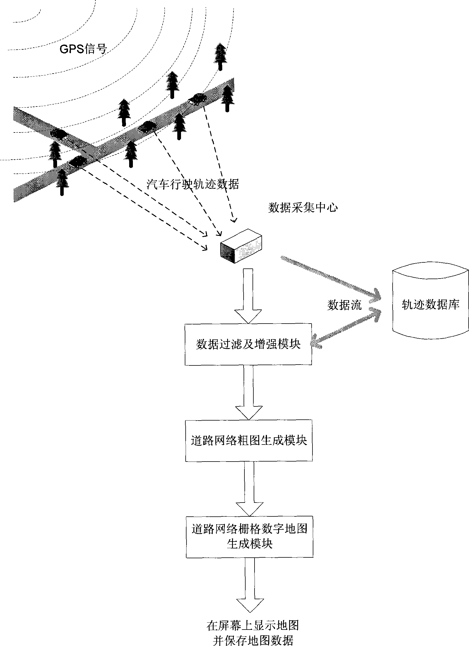
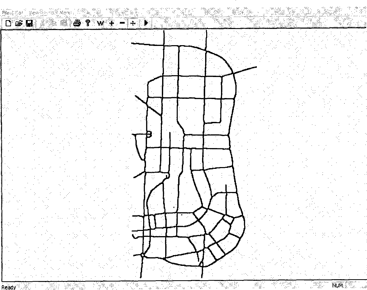
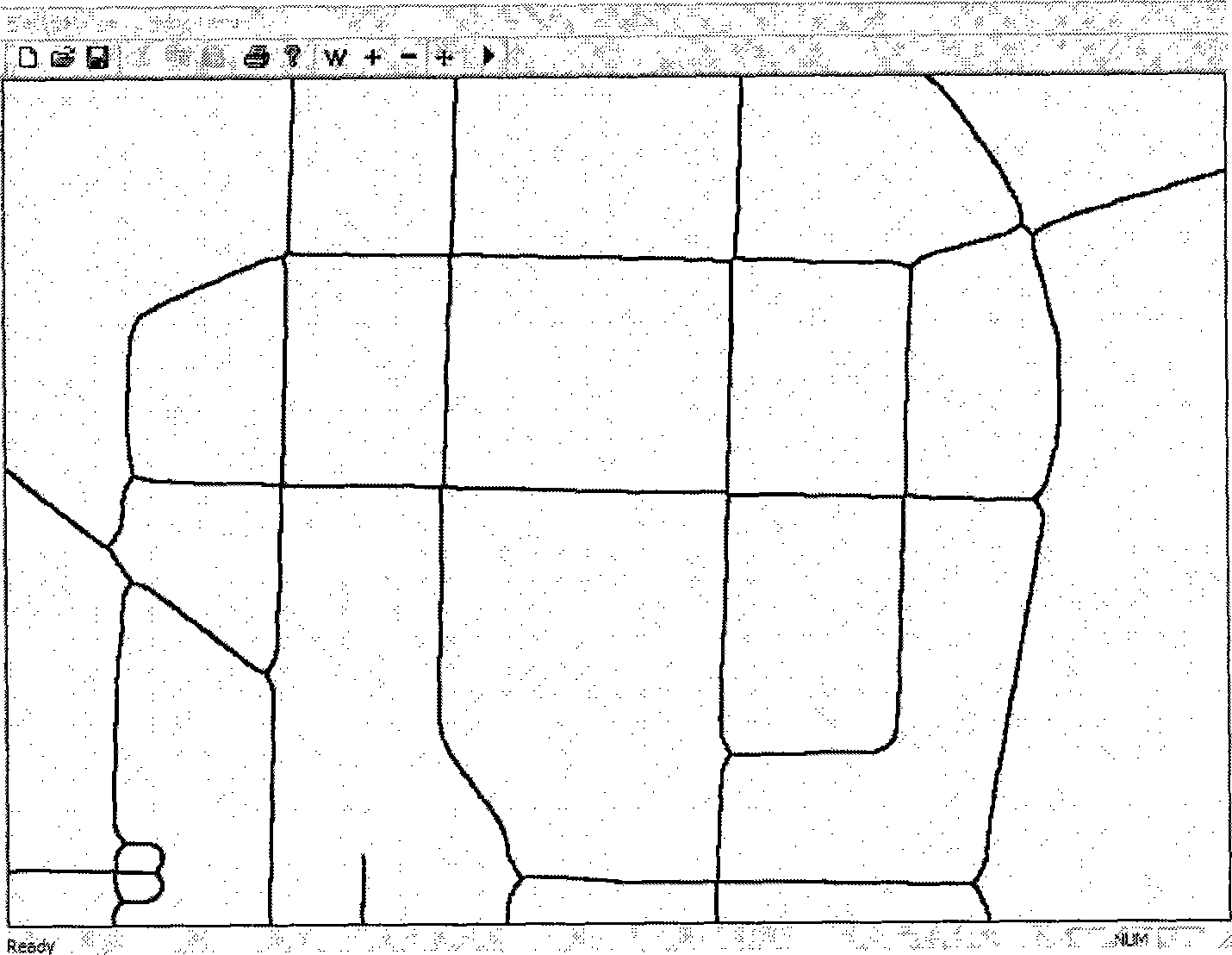
[0023] Implement the present invention to automatically generate the road network raster digital map as an example (the computer processing part adopts Microsoft VisualStudio 2005 compiling environment to realize) with the automobile driving track data collected on the part road network of Jilin City, Jilin City, Jilin Province, and its concrete process is divided into as follows Four modules (such as figure 1 shown):

[0024] 1. The data acquisition center receives the car driving trajectory data sent by the vehicle-mounted GPS device at a period of 5 seconds. The d...


PUM


Abstract

The invention relates to a GPS positioning-based road network grid digital map automatic generation method in the field of ground mapping. The invention is characterized in that vehicle-mounted GPS equipment is used for gathering data about the travelling track of a vehicle on a road network, that is, road information data; a computer is used for switching the travelling track data from geodetic coordinates to urban construction coordinates and then storing the travelling track data in a track database; the travelling track data in the track database is filtered and enhanced by the computer; the travelling track data after being subjected to processing, filtration and enhancement by the computer is then used for generating a sketch of a road network grid digital map; and finally, the computer is adopted to process the sketch and produce the road network grid digital map. The invention has the following advantages: the data source adopted by the invention is convenient and relatively cheap to acquire; and the road network grid digital map generated by the invention is complete and clear, has high precision, and changes in line with the actual road network, so that the map can better satisfy the application requirements for a road network map on timeliness and accuracy.

Description

technical field [0001] The invention relates to a map generation method in the technical field of surveying and mapping, in particular to a method for automatically generating a road network grid digital map based on GPS positioning. Background technique [0002] The road network raster digital map (hereinafter referred to as the road network map) is a bitmap that depicts the geographical characteristics and structure of the road network. It has many advantages such as convenient generation, detailed content, and easy acceptance by users. It can be widely used in car navigation systems and in the field of Intelligent Transportation Systems (ITS). With the progress of urbanization and rapid economic development, the road network update rate is increasing day by day. The existing road network map generation technology has disadvantages such as long period, poor accuracy, high cost, etc., resulting in the road network map update is always The dilemma of not keeping up with cha...

Claims


Application Information

Patent Timeline
Patent Type & Authority Applications(China)
IPC IPC(8): G01C21/32G09B29/00
Inventor 史文欢闫焱申抒含刘允才
Owner SHANGHAI JIAO TONG UNIV
Why Eureka
Try Eureka