Detection method for remote sensing day and night sea fog by stationary weather satellite

A geostationary meteorological satellite and detection method technology, applied in the field of marine environment monitoring, can solve the problem of inability to distinguish between low and medium clouds and sea fog, and achieve the effect of large coverage area and high time resolution

Inactive Publication Date: 2009-06-24
NAT SATELLITE METEOROLOGICAL CENT +1
View PDF0 Cites 23 Cited by
  • Summary
  • Abstract
  • Description
  • Claims
  • Application Information

AI Technical Summary

Problems solved by technology

However, the bispectral method alone cannot complet

Method used


Image

  • Detection method for remote sensing day and night sea fog by stationary weather satellite

Examples


Embodiment Construction

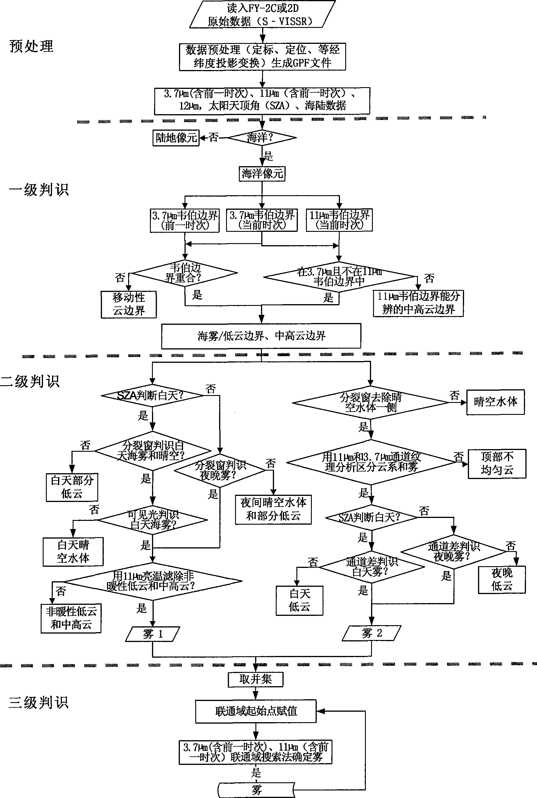
[0016] Method steps of the present invention are as follows:

[0017] 1. After data preprocessing, the Weber boundary method is used to conduct a first-level judgment on the boundary of sea fog, and the boundary of sea fog / low cloud and medium-high cloud is obtained, which is the boundary between sea fog / low cloud, medium-high cloud and clear sky water body the border between.

[0018] 1) Read in the raw data files (S-VISSR) of the FY-2C and FY-2D stationary meteorological satellites received and processed by the digital visual broadcasting system (DVBS) of the stationary meteorological satellites, and perform calibration and positioning of the S-VISSR data, data Correction, equal longitude and latitude projection and other preprocessing to obtain the projected GPF format file containing 5 channel data;

[0019] 2) From the GPF file, read in the current and previous time data of the mid-infrared 3.7μm channel, the current time and previous time data of the 11μm channel of the...


PUM

PropertyMeasurementUnit
Wavelengthaaaaaaaaaa

Abstract

The invention relates to a detection method of sea fog remotely sensed by stationary meteorological satellites in the daytime and at night. The detection method comprises the following steps: firstly receiving and processing a data file S-VISSR by utilizing the number of the stationary meteorological satellites and obtaining a GPF document containing 5 channel data after being projected through calibration and location, data amendment, latitude and longitude projection and other pretreatments; then extracting sea fog information by utilizing 4 channel data in the GPF document, 2 split window channels in a long wave infrared window region, 1 intermediate infrared channel of 3.7 Mu m and 1 visible light channel of 0.67 Mu m according to the kinematic characteristics and the spectral characteristics of the sea fog; and firstly filtering a movable cloud boundary and a medium-high cloud boundary and then filtering water body in clear sky and partial low clouds by adopting the tertiary judging method, and finally determining a sea fog region by utilizing the region growing method. The invention not only achieves the real-time monitoring of the sea fog in a wide ocean plane and the dynamic track of the sea fog region, but also provides an important basis for the shot forecast of the sea fog, thereby obtaining sea fog real-time monitoring images per hour at least.

Description

technical field [0001] The invention belongs to marine environment monitoring technology, in particular to a method for detecting sea fog in daytime and nighttime by remote sensing of stationary meteorological satellites. Background technique [0002] Sea fog (visibility less than 1km) has an impact on various human activities at sea due to the impact on the visibility of the sea surface. With the increasing social and economic activities at sea, sea fog has attracted more and more attention. Due to the scarcity of sea observation data, satellite remote sensing has become an important means of marine environment monitoring. [0003] After the United States launched the first geostationary environmental satellite GOES in 1975, the United States and Europe began to study satellite remote sensing sea fog / stratus cloud detection technology. Visible light and infrared channels are used during the day, and only infrared channels are used for detection at night. The first-generat...

Claims


Application Information

Patent Timeline
IPC IPC(8): G01S17/95
CPCY02A90/10
Inventor 吴晓京张苏平杨昌军张莫生李三妹刘应辰刘敬武
Owner NAT SATELLITE METEOROLOGICAL CENT
Why Eureka
Try Eureka