Method for autonomous navigation using geomagnetic field line map

An autonomous navigation and geomagnetic field technology, applied in the field of navigation, can solve problems such as mismatching, insufficient utilization of geomagnetic field information, and reduced positioning accuracy

Inactive Publication Date: 2009-09-02
NORTHWESTERN POLYTECHNICAL UNIV
View PDF0 Cites 43 Cited by
  • Summary
  • Abstract
  • Description
  • Claims
  • Application Information

AI Technical Summary

Problems solved by technology

However, in practical applications, these methods also continue the shortcomings of the terrain matching assisted navigation method: they cannot work independently without the INS, and the positioning accuracy obtained by the geomagnetic matching algorithm is greatly reduced when the INS has a large initial positioning error and heading error; Insufficient use of geomagnetic field information, only a single geomagnetic field amplitude feature is used for matching, and it is easy to fall into a mismatch; correlation matching and positioning can only be performed after accumulating a series of magnetic measurement data, resulting in poor real-time navigation Wait

Method used


Image

  • Method for autonomous navigation using geomagnetic field line map
  • Method for autonomous navigation using geomagnetic field line map
  • Method for autonomous navigation using geomagnetic field line map

Examples


Embodiment Construction

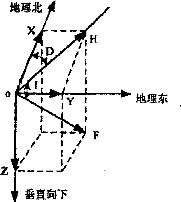
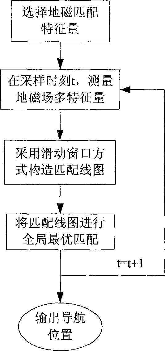
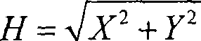
[0042] Refer to Figure 1~2 . The present invention uses multiple geomagnetic feature quantities as matching feature quantities. The method of selecting the matching feature quantity is as follows: the geomagnetic vector intensity is first selected as the matching feature quantity, and only when the local magnetic vector intensity fluctuation is small, the geomagnetic angle feature quantity is added together as the matching feature quantity. The definition of total geomagnetic field strength F, east component Y, north component X, vertical component Z, horizontal component H, magnetic declination angle D, and magnetic inclination angle I are as follows: figure 1 , The rectangular coordinate system used in the figure takes the observation point as the origin, and the geographic north, geographic east, and vertical downward are the positive directions of the x, y, and z axes, respectively. The mathematical relationship between the various characteristic quantities of the geomagnetic...


PUM


Abstract

The invention discloses a method for autonomous navigation using a geomagnetic field line map. Firstly, a plurality of characteristic quantities of the geomagnetic filed on a path of an aerial vehicle are measured continuously according to a preset frequency, and measurement data are used to build a matched line map of the corresponding characteristic quantities in a sliding window mode with fixed-point number; and a matched line map of the plurality of characteristic quantities is matched and compared with a reference map by using an algorithm for fining global optimum according to a matching similarity rule and a matching result fusion rule to acquire the position information of the aerial vehicle. The technology makes full use of the characteristics of the plurality of characteristic quantities of the geomagnetic field to calculate the accurate position of the aerial vehicle, avoids navigation accumulated error under a condition of long flight period, is particularly suitable for navigation in environments without typical geomorphic features such as ocean and plain, can meet requirements of future cruise missiles, unmanned aerial vehicles, submarines and the like for passive, all-sky time, all-weather and all-terrain navigation, and also can be used in civil area.

Description

Technical field [0001] The invention relates to a navigation method, in particular to an autonomous navigation method for matching geomagnetic field line diagrams. Background technique [0002] Navigation and positioning technology occupies a basic position in the development of modern science and technology, penetrates into various military and civilian fields, and shows an increasingly important role. However, the current more mature navigation and positioning methods still have great shortcomings under conditions such as long-term navigation tasks and environments without typical geomorphic features, and they need to be supplemented by other navigation methods. For example, if submarines only use INS technology, that is, inertial navigation technology, although they can navigate autonomously and have high short-term accuracy, there are accumulated errors. In deep water, it is difficult to use other existing technologies. Submarines have to surface regularly to correct them. , ...

Claims


Application Information

Patent Timeline
Patent Type & Authority Applications(China)
IPC IPC(8): G01C21/08G01C21/24
Inventor 葛致磊周军刘莹莹施桂国高智刚
Owner NORTHWESTERN POLYTECHNICAL UNIV
Why Eureka
Try Eureka