GPS navigation system and method capable of automatically updating map

A GPS navigation and automatic update technology, applied in the field of GPS navigation systems, can solve the problem that the electronic map does not mark geographical data, etc., and achieve the effects of timely updating the electronic map, optimizing navigation, and eliminating map blind spots

Inactive Publication Date: 2009-09-02
李丽丽
View PDF0 Cites 38 Cited by
  • Summary
  • Abstract
  • Description
  • Claims
  • Application Information

AI Technical Summary

Problems solved by technology

[0003] However, most of the update methods of electronic maps used in the current GPS navigation system are passive. Generally, the updated map information is transmitted to the carrier equipped with electronic maps by a third party in a wireless or wired manner. Independently do regular software updates on the electronic map. Under normal circumstances, the original information of the electronic map is already very large, which can basically mark most of the roads and building information in the big city, basically satisfying people's needs in the city. However, for some low-level roads in rural areas and suburbs, as well as some remote paths or roads under construction, complete and detailed geographical data are often not marked in electronic maps to help people complete navigation tasks

Method used


Image

  • GPS navigation system and method capable of automatically updating map

Examples


Embodiment Construction

[0016] In order to obtain the latest road network data, the present invention proposes a navigation system that obtains real-time road network data in the way of road practice. During the process of moving the navigation object, new road network data is also generated by the navigation software for storage. It is backed up in the original electronic map.

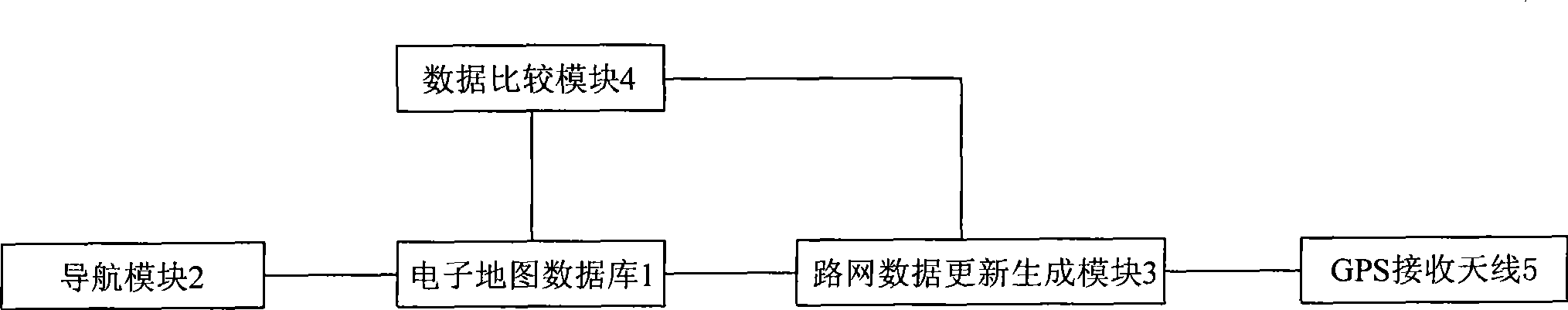
[0017] refer to figure 1 Shown, a kind of GPS navigation system that can automatically update map of the present invention, it comprises at least: electronic map database 1, navigation module 2, road network data update generation module 3, data comparison module 4 and GPS receiving antenna 5, wherein, The electronic map database 1 is used to store the road network data of the electronic map of the system; the navigation module 2 is connected with the electronic map database 1, and is used to find out guidance navigation in the electronic map database 1 according to the current position information of the navigation object ...


PUM


Abstract

The invention provides a GPS navigation system capable of automatically updating a map. The system comprises an electronic map data base, a navigation module, a road net data updating generation module, and a data comparison module, wherein the electronic map data base is used for storing the road net data of the electronic map of the system; the navigation module is used for finding out the navigation data guiding a navigation object to reach the set destination from the electronic map data base according to the current position information of the navigation object; the road net data updating generation module is used for recording the dynamic track of the moving navigation object according to the positioning information of the navigation object and taking the dynamic track as the current road net data; and the data comparison module is used for comparing the current road net data with the road net data of the electronic map in the electronic map data base and generating a data comparison result; and if the two groups of road net data are different, the currently updated road net data is stored in the electronic map data base so as to add the road net data information of the electronic map into the electronic map data base. When the navigation object moves, the system and the method can realize the automatic updating of the road net data of the electronic map and make the map show the actual road conditions more thoroughly, accurately and in detail so as to find out the best navigation route.

Description

technical field [0001] The invention relates to a navigation system, in particular to a GPS navigation system capable of automatically updating maps. Background technique [0002] With the rapid development of communication technology, a large number of satellite positioning technologies are applied to vehicle positioning and navigation. At present, the GPS system of the US military is mainly used to achieve vehicle positioning. It uses satellite technology to determine the geographic data such as longitude and latitude of the vehicle. Combined with the electronic map on the vehicle, it can intuitively and clearly display the specific location of the vehicle, and find the best search path according to the conditions set by people, so as to realize intelligent navigation. [0003] However, most of the update methods of electronic maps used in the current GPS navigation system are passive. Generally, the updated map information is transmitted to the carrier equipped with elect...

Claims


Application Information

Patent Timeline
Patent Type & Authority Applications(China)
IPC IPC(8): G01C21/30G01C21/34G01C21/36
Inventor 李丽丽
Owner 李丽丽
Why Eureka
Try Eureka