Method and device for capturing GPS satellite signals

A satellite signal capture and satellite signal technology, applied in the field of GPS positioning and navigation, can solve the problems of affecting system sensitivity and deteriorating non-coherent integration effect, and achieve the effects of improved capture sensitivity, intuitive and effective operation, and wide operability

Inactive Publication Date: 2009-12-30
SHANGHAI INFOTM MICROELECTRONICS
View PDF3 Cites 9 Cited by
  • Summary
  • Abstract
  • Description
  • Claims
  • Application Information

AI Technical Summary

Problems solved by technology

However, due to the characteristics of the GPS signal, that is, the period of the spreading code C/A code is 1 millisecond, and the period of the GPS message data is 20 millise

Method used


Image

  • Method and device for capturing GPS satellite signals
  • Method and device for capturing GPS satellite signals
  • Method and device for capturing GPS satellite signals

Examples


Example Embodiment

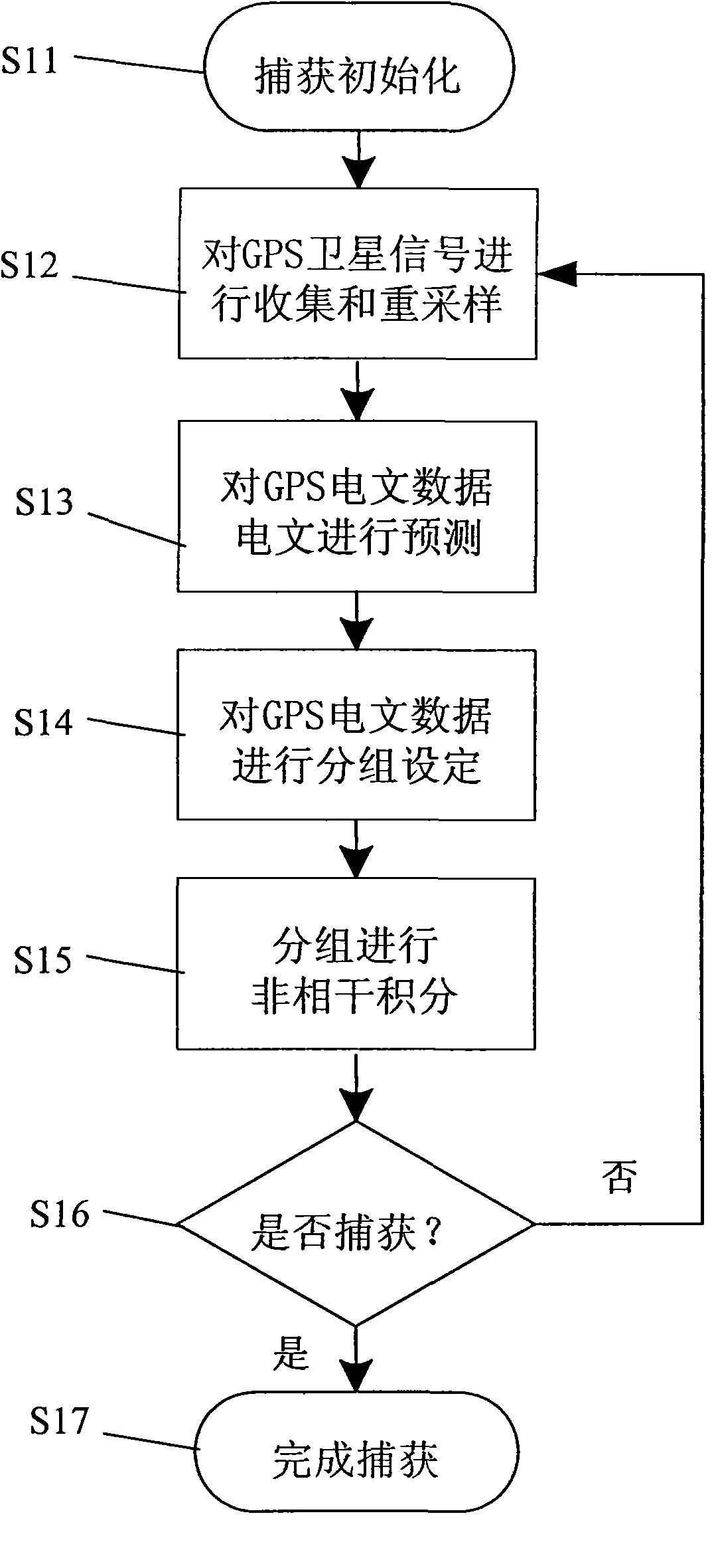
[0032] The specific implementation of the GPS satellite signal acquisition method and device of the present invention will be described in detail below in conjunction with the accompanying drawings.

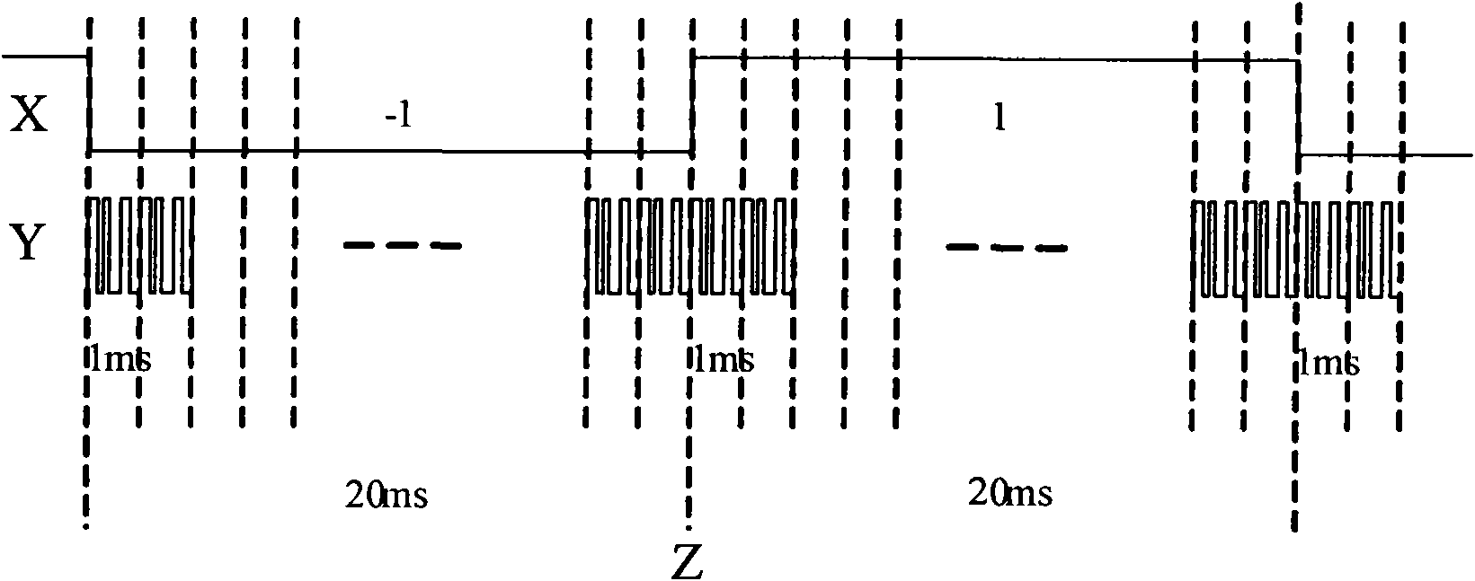
[0033] see figure 2 , figure 2 It is a GPS signal structure diagram, figure 2 The modulation relationship between GPS navigation satellite message data X and GPS C / A code sequence (modulated spreading code C / A) Y is revealed in . The length of each GPS navigation satellite message data bit is 20 milliseconds, and the possible data contained is 1 or -1. The C / A code sequence period of each GPS is 1 millisecond, therefore, within a 20 millisecond navigation message data bit, there are 20 complete C / A code sequences in total. figure 2 Z in is the bit boundary phase inversion.

[0034] The correlation operation within one C / A code sequence period is a coherent integration operation. The effect of non-coherent integration can be obtained by continuously performing coherent in...


PUM


Abstract

The invention discloses a method and a device for capturing GPS satellite signals, which comprises the following steps that: a GPS receiver carries out acquisition and re-sampling operations for the GPS satellite signals; the GPS receiver carries out boundary and message prediction for the acquired GPS satellite signal data; the GPS receiver carries out grouping and setting of non-coherent integration according to the predicted boundary position and message; the GPS receiver carries out computing operations of the non-coherent integration according to the finished setting mode of the non-coherent integration grouping respectively; and the GPS receiver judges the capturing result of the GPS satellite signals according to the computing results of the grouped non-coherent integration till finishing capture. Through the operation of the method, the method can effectively improve the signal integration length during GPS satellite capture, can operate across GPS navigation data, and greatly enhances the capturing sensitivity of the GPS signal receiver and the detection capacity of the weak signals. In addition, the invention also provides a corresponding realization device according to the method.

Description

technical field [0001] The present invention relates to the field of GPS (Global Positioning System) positioning and navigation, and more specifically refers to a method for capturing satellite signals with high sensitivity for a GPS satellite positioning and navigation receiver and a device for using the same. Background technique [0002] The GPS system is a fully mature and fully operational navigation and positioning system. The system provides positioning services within a global coverage area. Users around the world can obtain continuous and accurate three-dimensional position information and time information through GPS signal receivers. and exercise status information. With the promotion and development of GPS system, GPS positioning function is widely used in various fields of military and civilian use. At the same time, according to the advantages of GPS positioning and navigation, GPS positioning system is also used everywhere in sea, land and air. With the devel...

Claims


Application Information

Patent Timeline
IPC IPC(8): G01S5/02
Inventor 刘春晖金荣伟李兴仁林锦麟张正荣陈谦
Owner SHANGHAI INFOTM MICROELECTRONICS
Why Eureka
Try Eureka