Road section recognizing and matching method based on decision-making circle

A matching method and decision-making circle technology, which is applied to road network navigators, satellite radio beacon positioning systems, measurement devices, etc., can solve problems such as difficult real-time processing of data, complicated principles or calculations, and labor and material resources to avoid problems. The effect of matching cost increases

Inactive Publication Date: 2010-06-23
BEIJING UNIV OF TECH
View PDF0 Cites 7 Cited by
  • Summary
  • Abstract
  • Description
  • Claims
  • Application Information

AI Technical Summary

Problems solved by technology

However, for parallel roads with similar distances and directions, it is difficult to use this road segment matching method to distinguish
Other map matching algorithms such as the shortest path, neural network, fuzzy logic and other methods are generally more complex in principle or calculation, and it is difficult to process data in real time
The method of adding a marking station on the r

Method used


Image

  • Road section recognizing and matching method based on decision-making circle
  • Road section recognizing and matching method based on decision-making circle

Examples


Embodiment Construction

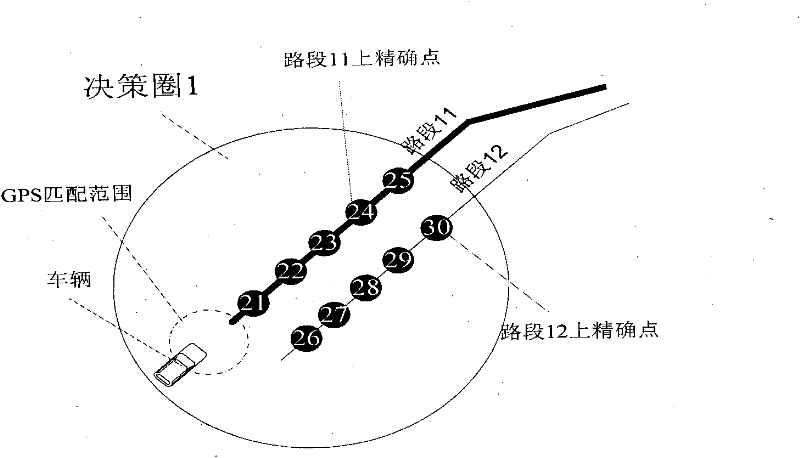
[0022] Here we take two parallel and similar road sections as an example to illustrate the method of the present invention.

[0023] In urban roads, two road sections are often arranged in parallel and similar, one is road section 11, and the other is road section 12, such as figure 2 shown.

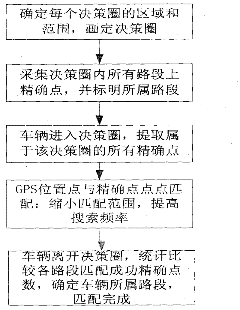
[0024] Step 1. The decision-making circle is a circular area whose center is the easily confused area and whose radius is the range that can cover the confusing area, and sets numbers for each decision-making circle.

[0025] figure 2 Middle road section 11 and road section 12 are close in distance and in the same direction, and it is difficult to distinguish them by conventional map matching methods. Therefore, the decision circle is set to cover two difficult-to-distinguish road sections for special treatment. figure 2 The middle decision circle is numbered 1.

[0026] Step 2: Collect precise points on all road sections within the decision circle: collect the same number of preci...


PUM


Abstract

The invention discloses a road section recognizing and matching method based on decision-making circle and is mainly applicable to the path recognition of a vehicle navigation system and other path recognition fields employing positioning technology. The invention also solves the problem of inaccurate recognition of complicated road section of the vehicle navigation system. Decision-making circles are arranged in the road section areas difficult to be matched with the general map matching method, accurate points of all road sections in the decision-making circles are collected, the GPS position points of vehicles in the decision-making circles are matched with the accurate points through point-to-point mode, and the number of successful matches of the accurate points in each road section is under statistical comparison to determine the road section wherein the vehicle is located. The method overcomes the inaccurate matching problem of the general algorithm, also avoids erecting the site beacon station equipment and accordingly saves large quantity of human and material resources.

Description

technical field [0001] The invention belongs to the field of intelligent traffic map matching, and is applied to path recognition in vehicle navigation systems and other fields involving path recognition using positioning technology. Background technique [0002] In the vehicle navigation system, road segment identification and matching technology is one of the key technologies. When the vehicle is driving, the on-board equipment installed on the vehicle matches the GPS vehicle positioning information with the on-board electronic map, identifies the location of the vehicle on the road section, gives driving prompt information, and provides decision support for the driver. [0003] In the actual road network, the main road and the auxiliary road are usually in the same direction, parallel, and close to each other. The distance between the main road and the auxiliary road in the same driving direction is often about 5 meters. The existing GPS accuracy is usually greater than 1...

Claims


Application Information

Patent Timeline
IPC IPC(8): G01C21/30G01S19/42
Inventor 陈艳艳王东柱
Owner BEIJING UNIV OF TECH
Why Eureka
Try Eureka