Spatial overlap analysis method and system used in geographic information system

A geographic information system, overlay analysis technology, applied in the direction of electrical digital data processing, special data processing applications, instruments, etc., to achieve the effect of good cost performance and high overlay efficiency

Active Publication Date: 2010-06-23
INST OF COMPUTING TECH CHINESE ACAD OF SCI
View PDF0 Cites 42 Cited by
  • Summary
  • Abstract
  • Description
  • Claims
  • Application Information

AI Technical Summary

Problems solved by technology

In most cases, the raster data structure is much simpler than the vector da

Method used


Image

  • Spatial overlap analysis method and system used in geographic information system
  • Spatial overlap analysis method and system used in geographic information system
  • Spatial overlap analysis method and system used in geographic information system

Examples


Embodiment Construction

[0057] In order to make the purpose, technical solution and advantages of the present invention clearer, a spatial overlay analysis method and system used in geographic information systems of the present invention will be further described in detail in conjunction with the accompanying drawings and embodiments. It should be understood that the specific embodiments described here are only used to explain the present invention, not to limit the present invention.

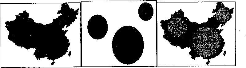
[0058] A spatial overlay analysis method and system used in a geographic information system (Geographic Information System, GIS) of the present invention is to convert vector data into raster data, and perform an overlay operation on the raster data, and then superimpose The method of transforming the raster data of the operation into vector data realizes the raster-based spatial overlay analysis in GIS.

[0059] The technical problems to be solved in the present invention include:

[0060] 1. Vector data rasterizati...


PUM


Abstract

The invention discloses spatial overlap analysis method and system used in a geographic information system (GIS). The method comprises the following steps of: converting vector data input to layers in the GIS into raster data, and representing by adopting run coding; executing overlap operation on the raster data represented by adopting run coding; and converting the overlapped raster data into the vector data to obtain overlapped layers. The invention can avoid the disadvantages of computation geometric algorithms and increases the overlap efficiency by utilizing the advantages of a raster algorithm.

Description

technical field [0001] The present invention relates to the field of geographic information system (Geographic Information System, GIS), in particular to a spatial overlay analysis method and system used in the geographic information system. Background technique [0002] Geographic Information System (Geographic Information System or Geo-Informationsystem, GIS) is sometimes called "geographic information system" or "resource and environmental information system". It is a specific and very important spatial information system. With the support of computer hardware and software systems, it is a variety of geospatial entity data and their relationships in the space of the entire or part of the earth's surface (including the atmosphere), including spatial positioning data, graphic data, remote sensing image data, attribute data, etc. Technical systems for acquisition, storage, management, calculation, analysis, display and description. It is used to analyze and deal with vario...

Claims


Application Information

Patent Timeline
IPC IPC(8): G06F17/30
Inventor 董慧程振林方金云
Owner INST OF COMPUTING TECH CHINESE ACAD OF SCI
Why Eureka
Try Eureka