Method for drawing novel navigation chart of ship navigation guidance system

A technology of ships and navigation methods, applied in the field of drawing new navigation charts, can solve problems such as threats to the navigation safety of ships in the navigable environment, and achieve the effects of reducing economic losses, reducing the occurrence of ship accidents, and accelerating development.

Inactive Publication Date: 2010-06-23
DALIAN MARITIME UNIVERSITY
View PDF0 Cites 8 Cited by
  • Summary
  • Abstract
  • Description
  • Claims
  • Application Information

AI Technical Summary

Problems solved by technology

In addition, the channel construction, management and navigation guarantee mechanism still needs to be improved, and there is no navigation map tha

Method used


Image

  • Method for drawing novel navigation chart of ship navigation guidance system
  • Method for drawing novel navigation chart of ship navigation guidance system
  • Method for drawing novel navigation chart of ship navigation guidance system

Examples


Embodiment Construction

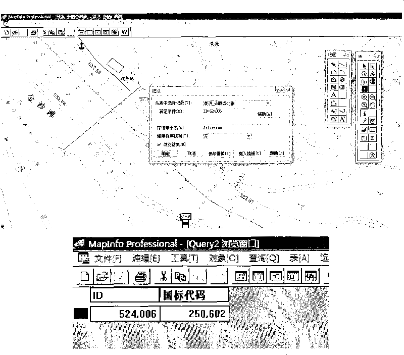
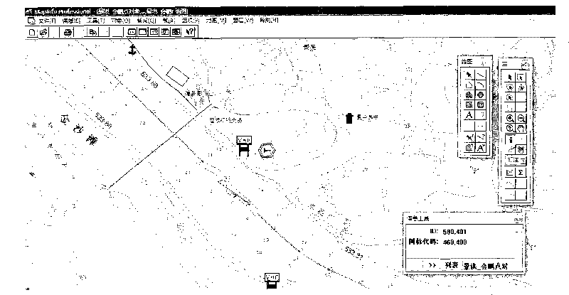
[0018] The drawing of the navigation chart in the present invention is described in detail by taking MapInfo operating software as an example. MapInfo Operating Software is the world's leading mapping and geographic analysis software, providing industry-leading business mapping solutions and enabling precise, detailed data analysis. MapInfo is one of the most widely used application software in the current map drawing software, and it is a relatively complete, powerful, comprehensive and intuitive desktop map information system in the current world. In terms of practicability, the interface of MapInfo system is simple and the concept is clear, which is in line with the design ideas and habits of engineering designers. The whole system is built on a unified database with a complete and unified model.

[0019] The drawing of the new navigation chart is mainly to supplement and improve the details of the navigation channel on the basis of comparison with the previous channel han...


PUM


Abstract

The invention discloses a method for drawing a novel navigation chart of a ship navigation guidance system, which comprises the following steps of: a, layering information, comprising a point object layer, a recommended route layer and a text layer, wherein the three layers are all provided with ID fields for encoding all objects, and the point object layer is further provided with national standard fields; b, loading national standard codes; and c, making character symbols and legend symbols. Crew can effectively obtain navigation channel information through the novel navigation chart drawn by the method for drawing the novel navigation chart of the ship navigation guidance system, and retrieve and query the navigation channel information, and the information, such as the general topographic features of the channel, channel conditions, navigation obstruction conditions, navigation notice, reference navigation method and the like, is displayed. The safe navigation of the ship is ensured, the occurrence of ship accidents is reduced, the harm to personal safety is decreased, and the economic loss is reduced. Therefore, the development of navigation industry is quickened. The method is suitable to be popularized in ship sailing guidance widely.

Description

technical field [0001] The invention relates to a method for drawing a new navigation chart, in particular to a method for drawing a new navigation chart for a ship navigation guidance system. Background technique [0002] As early as the "Tenth Five-Year Plan" period, the Ministry of Communications clearly stated that it is necessary to focus on solving fundamental issues such as the quality, efficiency, safety, and service of transportation development, and to comprehensively promote the informatization of highway and waterway transportation, and to give priority to informatization. [0003] Most of the rivers in mountainous areas have turbulent water flow, many dangerous shoals, disordered flow, numerous reefs, and dangerous navigation conditions of the waterway. In addition, the channel construction, management and navigation guarantee mechanism still needs to be improved, and there is no navigation map that can be used for reference by ship pilotage operations. The dang...

Claims


Application Information

Patent Timeline
IPC IPC(8): G06F17/30G09B29/00
Inventor 王立军李阳张英俊
Owner DALIAN MARITIME UNIVERSITY
Why Eureka
Try Eureka