Semi-supervised multi-spectral remote sensing image segmentation method based on spectral clustering

A technology of remote sensing image and spectral clustering algorithm, which is applied in the preprocessing of multispectral remote sensing images and the segmentation of multispectral remote sensing images. The effect is good, the classification accuracy is improved, and the regional consistency is good.

Inactive Publication Date: 2010-06-23
XIDIAN UNIV
View PDF0 Cites 54 Cited by
  • Summary
  • Abstract
  • Description
  • Claims
  • Application Information

AI Technical Summary

Problems solved by technology

However, when the semi-supervised spectral clustering algorithm is applied to the segmentation of multispectral remote sensing images, it will face the problem of large amount of data. Williams et al. Spectral clustering of the approximation method, which ...

Method used


Image

  • Semi-supervised multi-spectral remote sensing image segmentation method based on spectral clustering
  • Semi-supervised multi-spectral remote sensing image segmentation method based on spectral clustering
  • Semi-supervised multi-spectral remote sensing image segmentation method based on spectral clustering

Examples


Embodiment Construction

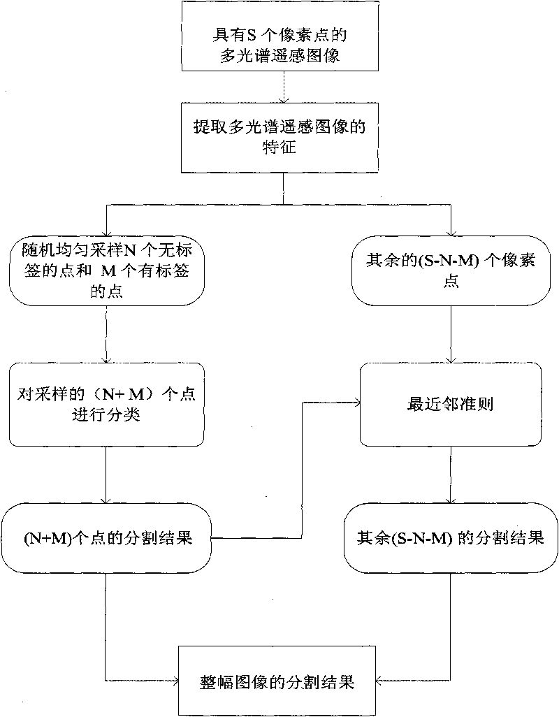
[0041] refer to figure 1 , the specific implementation steps of the present invention are as follows:

[0042] Step 1: Extract input image features.

[0043] Each pixel in the input image is represented by a feature vector to obtain an image feature set, and the feature vector is the gray value of each band of the input image.

[0044] Step 2: Randomly uniformly sample N unlabeled points and M labeled points in the input image.

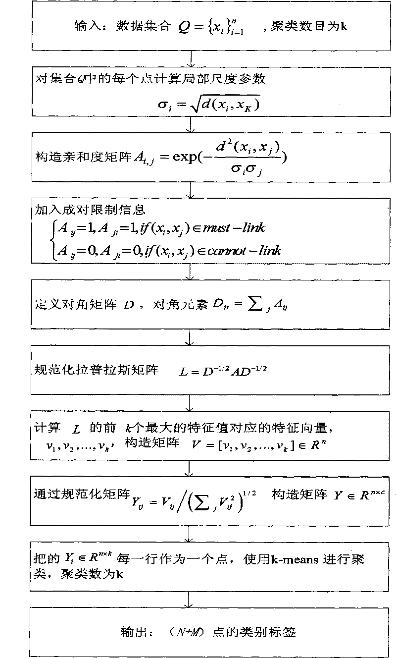
[0045] For a multispectral remote sensing image with S pixels, a set of N unlabeled points and M labeled points are randomly and uniformly sampled Q = { x i } i = 1 n , n=N+M, where M labeled points, it is in the set of labeled points, select the set of points of each category with the same label, and randomly select M / in each set k points, k is the number of c...


PUM


Abstract

The invention discloses a semi-supervised multi-spectral remote sensing image segmentation method based on spectral clustering; the segmentation process includes that: (1) the characteristics inputted to the multi-spectral sensing image are extracted; (2) N points without labels and M points with labels are randomly and evenly sampled from a multi-spectral sensing image with S pixel points to form a set n which is the summation of N and M, wherein M points with labels are used for creating pairing limit information Must-link and Cannot-link sets; (3) the sampled point set is analyzed through semi-supervised spectral clustering to obtain the class labels of the n (n=N+M) points; (4) the sampled n (n=N+M) points are used as the training sample to classify the rest (S-N-M) points through nearest-neighbor rule, each pixel point is assigned with a class label according to the class of the pixel point and is used as the segmentation result of the inputted image. Compared with prior art, the invention has good image segmentation effect, strong operability, improves the classification accuracy, avoids searching the optimum parameters through repeated test, has small limit on image size and is better applicable to the segmentation of multi-class multi-spectral sensing images.

Description

technical field [0001] The invention belongs to the technical field of image processing, relates to multispectral remote sensing image segmentation, and can be used for preprocessing the multispectral remote sensing image. Background technique [0002] Multi-spectral remote sensing image analysis technology comprehensively utilizes multi-band satellites. Compared with traditional remote sensing image analysis technology, it has unique advantages in the detection of ground targets, especially stationary targets, and has better interpretation and identification of various natural phenomena and processes. Good application prospects. Segmentation of remote sensing images is one of the key technologies in the analysis and application of remote sensing images. Fast and high-precision multispectral remote sensing image segmentation methods are the prerequisites for various practical applications. [0003] At present, there are many segmentation methods for multispectral remote sen...

Claims


Application Information

Patent Timeline
IPC IPC(8): G06T7/00G06K9/66G01S7/48
CPCG06K9/00657G06K9/342G06K9/6224G06V20/188G06V10/267G06V10/7635G06F18/2323
Inventor 张向荣焦李成王婷侯彪公茂果刘若辰李阳阳马文萍
Owner XIDIAN UNIV
Why Eureka
Try Eureka