Method for creating distance map based on monocular camera machine vision

A technology of machine vision and distance map, which is applied in instrumentation, image enhancement, image analysis, etc., can solve problems such as expensive distance measurement equipment and difficulty in creating distance maps

Active Publication Date: 2010-07-28
INST OF SEMICONDUCTORS - CHINESE ACAD OF SCI
View PDF0 Cites 26 Cited by
  • Summary
  • Abstract
  • Description
  • Claims
  • Application Information

AI Technical Summary

Problems solved by technology

[0008] Aiming at the special structure of the car road, the present invention proposes a distance map creation method based on monocular machine vision. Through the calibration of the vehicle-mounted camera, the correspond

Method used


Image

  • Method for creating distance map based on monocular camera machine vision
  • Method for creating distance map based on monocular camera machine vision
  • Method for creating distance map based on monocular camera machine vision

Examples


Embodiment Construction

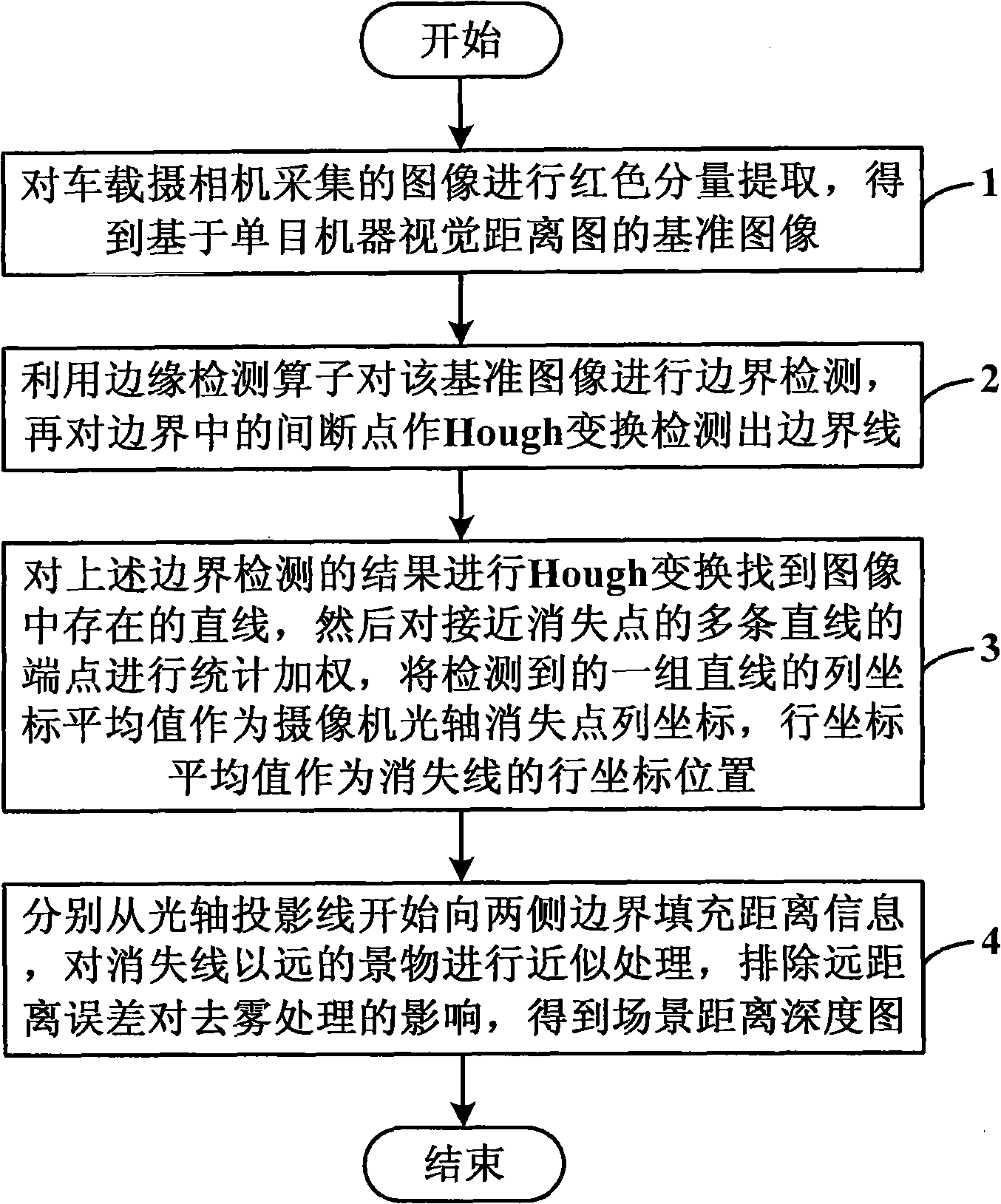
[0030] In order to make the object, technical solution and advantages of the present invention clearer, the present invention will be described in further detail below in conjunction with specific embodiments and with reference to the accompanying drawings.

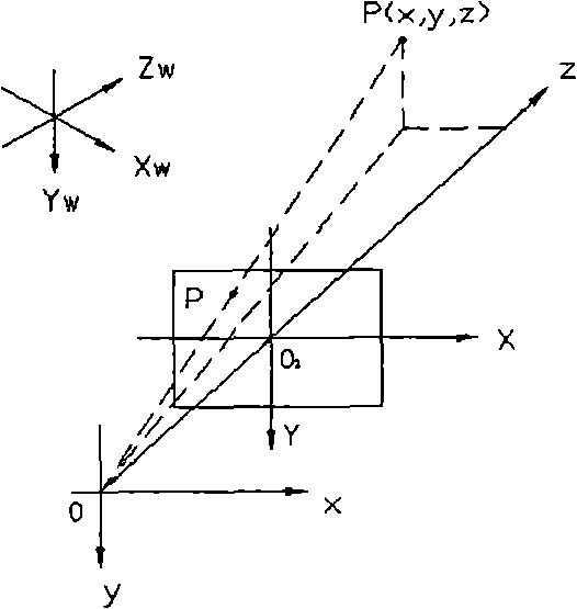
[0031] The distance map creation method based on monocular machine vision provided by the present invention completes the construction of the distance and depth map of the road scene through the principle of monocular machine vision, and solves the key problem of dehazing in the atmospheric scattering model. In order to obtain the depth information of the target scene, the experimental camera is first calibrated to obtain the calibration parameters, and then the linear imaging model is used to establish the scene depth map. For the driving road surface, the x value at the central axis position of the camera is zero, and the projection equation is simplified to z and y relationship between, such as Figure 4 Shown:

[003...


PUM


Abstract

The invention discloses a method for creasing a distance map based on monocular camera machine vision, which comprises the following steps: carrying out red component extraction on an image collected by a car camera for obtaining a baseline image; utilizing an edge detection operator for carrying out boundary detection on the baseline image, and further carrying out Hough transform on discontinuity points in the boundary for detecting a boundary line; carrying out the Hough transform on the boundary detection result for finding out straight lines in the image, then carrying out statistical weighting on end points of a plurality of straight lines approaching a vanishing point, taking the average value of detected column coordinates of a group of the straight lines as the column coordinate of the vanishing point of an optical axis of the camera, and taking the average value of row coordinates as the row coordinate position of a vanishing line; and respectively filling distance information from a projection line of the optical axis to the boundaries on the two sides, carrying out approximate treatment on scenes being far away from the vanishing line, eliminating the impacts of long-distance errors on defogging treatment and obtaining the distance-depth map of the scenes. The utilization of the method can solve the problems of difficult creation of the distance map and expensive distance measuring equipment during model defogging.

Description

technical field [0001] The invention relates to the technical field of image processing of vehicle-mounted assisted driving systems, in particular to a method for creating a distance map based on monocular machine vision. Background technique [0002] The current research on driver assistance systems is mostly focused on the automatic driving of vehicles in fine weather, and there is little research on scene recovery in bad weather; domestic and foreign research on image defogging mainly focuses on the following methods: 1. Histogram equalization algorithm; 2. Based on the theory of color constancy, dehaze the image for color and contrast restoration; 3. Restoration method based on the atmospheric scattering model. [0003] Among them, the histogram equalization algorithm is a commonly used simple and effective enhancement method, which is based on probability theory, and corrects the histogram of the image through grayscale mapping to make it have a flat distribution. Degr...

Claims


Application Information

Patent Timeline
IPC IPC(8): G06T7/00G06T5/00
Inventor 刘红军周燕王新伟
Owner INST OF SEMICONDUCTORS - CHINESE ACAD OF SCI
Why Eureka
Try Eureka