Target parcel ground surface temperature simulation and optimization method

A technology of surface temperature and optimization method, applied in special data processing applications, instruments, electrical digital data processing, etc., can solve the problems of lack of feasibility in planning and design work, and achieve the effects of high reliability, rapid extraction, and great application prospects

Inactive Publication Date: 2010-10-20
ZHEJIANG UNIV
View PDF3 Cites 14 Cited by
  • Summary
  • Abstract
  • Description
  • Claims
  • Application Information

AI Technical Summary

Problems solved by technology

Few scholars have introduced the discipline of urban planning to study the urban thermal environment, and few scholars have combined artificially collected planni

Method used


Image

  • Target parcel ground surface temperature simulation and optimization method
  • Target parcel ground surface temperature simulation and optimization method
  • Target parcel ground surface temperature simulation and optimization method

Examples


Embodiment Construction

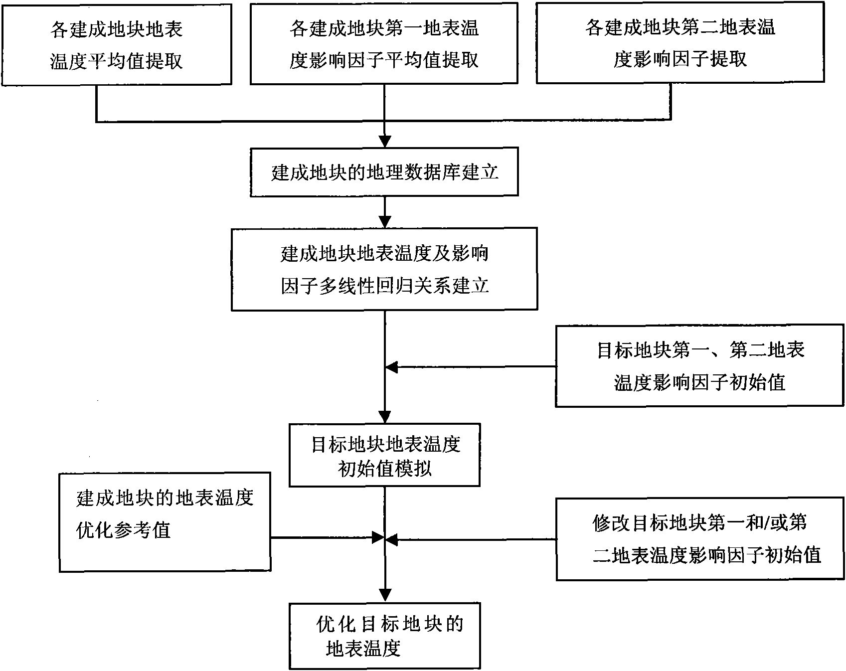
[0019] The present invention uses remote sensing data and vector data of remote sensing images of multiple different built land blocks as basic data. Each built-up plot has the same physical and geographical conditions as the target plot. The so-called same natural and geographical conditions means that the built plot and the target plot have the same natural factors that affect the surface temperature. The so-called natural factors here refer to the geographical latitude and longitude, meteorological conditions and topographic conditions of the plot.

[0020] As a specific embodiment of the present invention, the average value of the first surface temperature influencing factor and the average value of the surface temperature of the built-up plot can be extracted from the remote sensing data of the same remote sensing image with thermal infrared bands of the built-up plot; it can also be The average value of the first surface temperature influencing factor of the built-up lan...


PUM


Abstract

The invention discloses a target parcel ground surface temperature simulation and optimization method, which comprises the following steps: correspondingly obtaining the first ground surface temperature influence factor average value, the second ground surface temperature influence factor data and the ground surface temperature average value from remote sensing data and vector data of different built parcel remote sensing images, and establishing a geographical data base; using attribute data of the geographical data base for establishing the multiple regression relationship among the ground surface temperature average value, the first ground surface temperature influence factor average value and the second ground surface temperature influence factor data of the built parcels; obtaining the target parcel ground surface temperature initial value through the first ground surface temperature influence initial value, the second ground surface temperature influence initial value of the target parcels and the multiple regression relationship; regulating the ground surface temperature initial value into the ground surface temperature optimization value of the built parcels through regulating the first ground surface temperature influence factor and/or the second ground surface temperature influence factor initial value of the target parcels according to the multiple regression relationship; and obtaining the optimized ground surface temperature of the target parcels.

Description

technical field [0001] The invention relates to remote sensing image analysis, processing and application, in particular to a method for simulating and optimizing the surface temperature of a target plot, which can be used to promote the improvement of urban thermal environment. Background technique [0002] As a basic element of the human living environment, temperature is an important monitoring index to measure the urban thermal environment. Due to the defects of traditional ground observation and other technologies, it is difficult to obtain large-scale air temperature raster data, and the accuracy of the obtained data is not ideal. The development of thermal infrared satellite remote sensing technology provides a basic means for monitoring urban thermal field and obtaining large-area urban surface temperature information, thereby reducing human interference in local environments, enabling more intuitive and quantitative research on urban thermal environment, and the info...

Claims


Application Information

Patent Timeline
IPC IPC(8): G06F17/50
Inventor 王伟武张雍雍李国梁
Owner ZHEJIANG UNIV
Why Eureka
Try Eureka