Construction method for digital elevation model for discrete expression of landform on earth surface

A digital elevation model, the technology of the earth's surface, applied in 3D modeling, cross-section depiction, image data processing, etc., can solve problems such as errors, damage to known point relationships, large errors, etc.

Inactive Publication Date: 2010-12-01
INST OF GEOGRAPHICAL SCI & NATURAL RESOURCE RES CAS
View PDF0 Cites 40 Cited by
  • Summary
  • Abstract
  • Description
  • Claims
  • Application Information

AI Technical Summary

Problems solved by technology

[0010] The existing spatial interpolation model often ignores the spatial correlation of the sampling points when obtaining the values ​​of the interpolation points, so that the relationship between the known points is destroyed, which eventually leads to large errors and even various errors.
In previous studies, although Evans recognized that slope surface, aspect and curvature are important variables reflecting local topographical laws [2] Evans I S.An Integrated System of Terrain Analysis & Slope Mapping.Dept.of Geography, University of Durham, 1979, but he did not use them to express digital terrain models

Method used


Image

  • Construction method for digital elevation model for discrete expression of landform on earth surface
  • Construction method for digital elevation model for discrete expression of landform on earth surface
  • Construction method for digital elevation model for discrete expression of landform on earth surface

Examples


Embodiment Construction

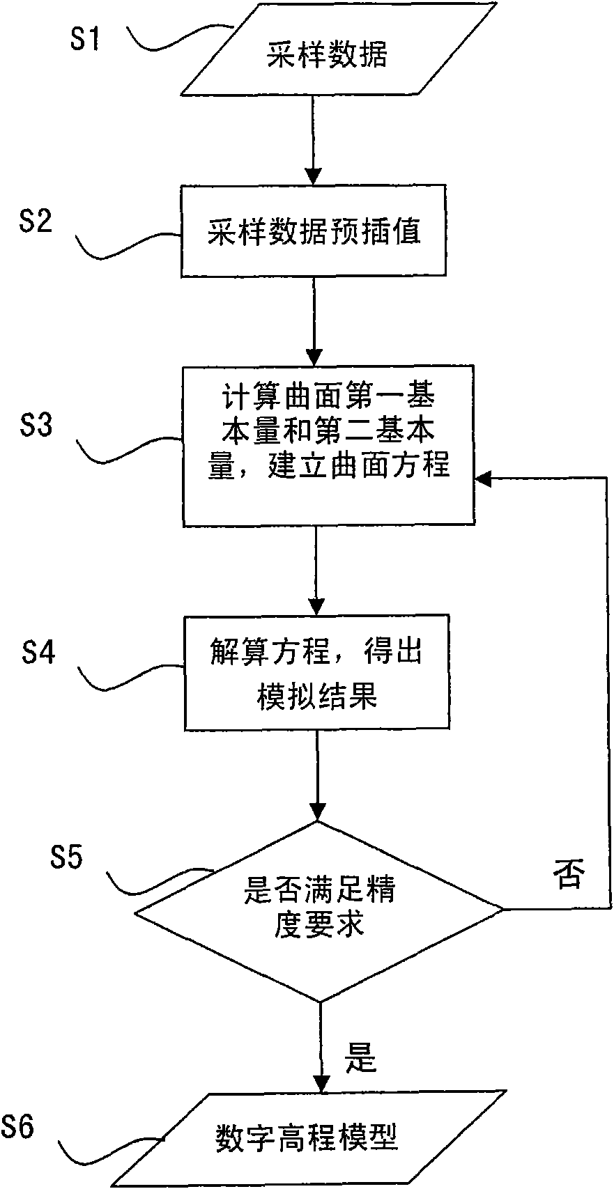
[0039] The detailed problems involved in the technical solutions of the present invention will be described in detail below with reference to the accompanying drawings.

[0040] The invention establishes a high-precision digital elevation model (HASM) discretely expressing the topography of the earth's surface based on the surface theory. The classical surface theory is the starting point of the present invention, and it is also the difference between HASM and the previous generation method of digital elevation model. The digital elevation model theory established based on the basic laws of surface theory is more mature, and its accuracy is much higher than other methods. The present invention uses Gauss equation as basic equation and elevation sampling point as constraint condition, and converts digital elevation model simulation into solving terrain surface equation system SU n+1 =T n , the terrain surface equation system is a large sparse linear equation system, and each ...


PUM


Abstract

The invention discloses a construction method for a digital elevation model for discrete expression of landform on the earth surface. The construction method comprises the following steps of: extracting elevation values of sampling points from the original data of the earth surface and performing spatial discretization on the elevation values to generate a plurality of landform curved surface grid points of the known elevation values of the sampling points; solving the elevation values of the landform curved surface grid points of non-sampling points; calculating first fundamental quantity and second fundamental quantity of each landform curved surface grid point according to the elevation values of all landform curved surface grid points and establishing a landform curved surface equation set by using a Gauss equation and elevation sampling points; solving the landform curved surface equation set by using a Gauss-Seidel iterative algorithm, wherein a simulation result of the digital elevation model is obtained after each iteration is finished; judging whether the simulation result of the digital elevation model meets the accuracy requirement; if the simulation result meets the requirement, stopping the iterative computation and outputting a group of ordered values to express the digital elevation model of a ground elevation entity in an array form, wherein the digital elevation model is used for the discrete expression of the landform on the earth surface; and if the simulation result does not meet the requirement, repeating the iterative computation.

Description

technical field [0001] The invention belongs to the technical field of earth observation and navigation, and relates to a method for generating a curved surface of a geographic information system, in particular to a method for constructing a digital elevation model. Background technique [0002] Digital Elevation Model (DEM) is a discrete representation of the topography and landforms on the earth's surface, and is the data base for various spatial analysis of GIS. In the fields of road design and military exercises, DEM, as an important achievement of digital terrain simulation, has become one of the basic contents of the national spatial data infrastructure, and has been incorporated into the digital spatial data framework for large-scale production. [0003] DEM has come a long way since it was first proposed in 1958 by Professor Miller of the American College of Anesthesiology and Engineering for highway design. Due to the wide application of DEM, the research on the ac...

Claims


Application Information

Patent Timeline
Patent Type & Authority Applications(China)
IPC IPC(8): G01C7/02G01C5/00G06T17/50G06T17/05
Inventor 岳天祥陈传法杜正平
Owner INST OF GEOGRAPHICAL SCI & NATURAL RESOURCE RES CAS
Why Eureka
Try Eureka