Aviation polarization multi-spectrum image registration method

A multi-spectral image and multi-spectral technology, applied in the fields of image stitching, aerial polarization multi-spectral image registration, and scene matching, can solve the problems of poor real-time performance and large amount of calculation, reduce registration deviation, and facilitate hardware experiments. Effect

Inactive Publication Date: 2010-12-22
NORTHWESTERN POLYTECHNICAL UNIV
View PDF10 Cites 13 Cited by
  • Summary
  • Abstract
  • Description
  • Claims
  • Application Information

AI Technical Summary

Problems solved by technology

[0005] From the published literature and patents, the existing image registration methods are all based on the image content, which needs to be calculated pixel by pixel, which has the disadvantages of large amount of calculation and poor real-time performance.

Method used


Image

  • Aviation polarization multi-spectrum image registration method
  • Aviation polarization multi-spectrum image registration method
  • Aviation polarization multi-spectrum image registration method

Examples


Embodiment Construction

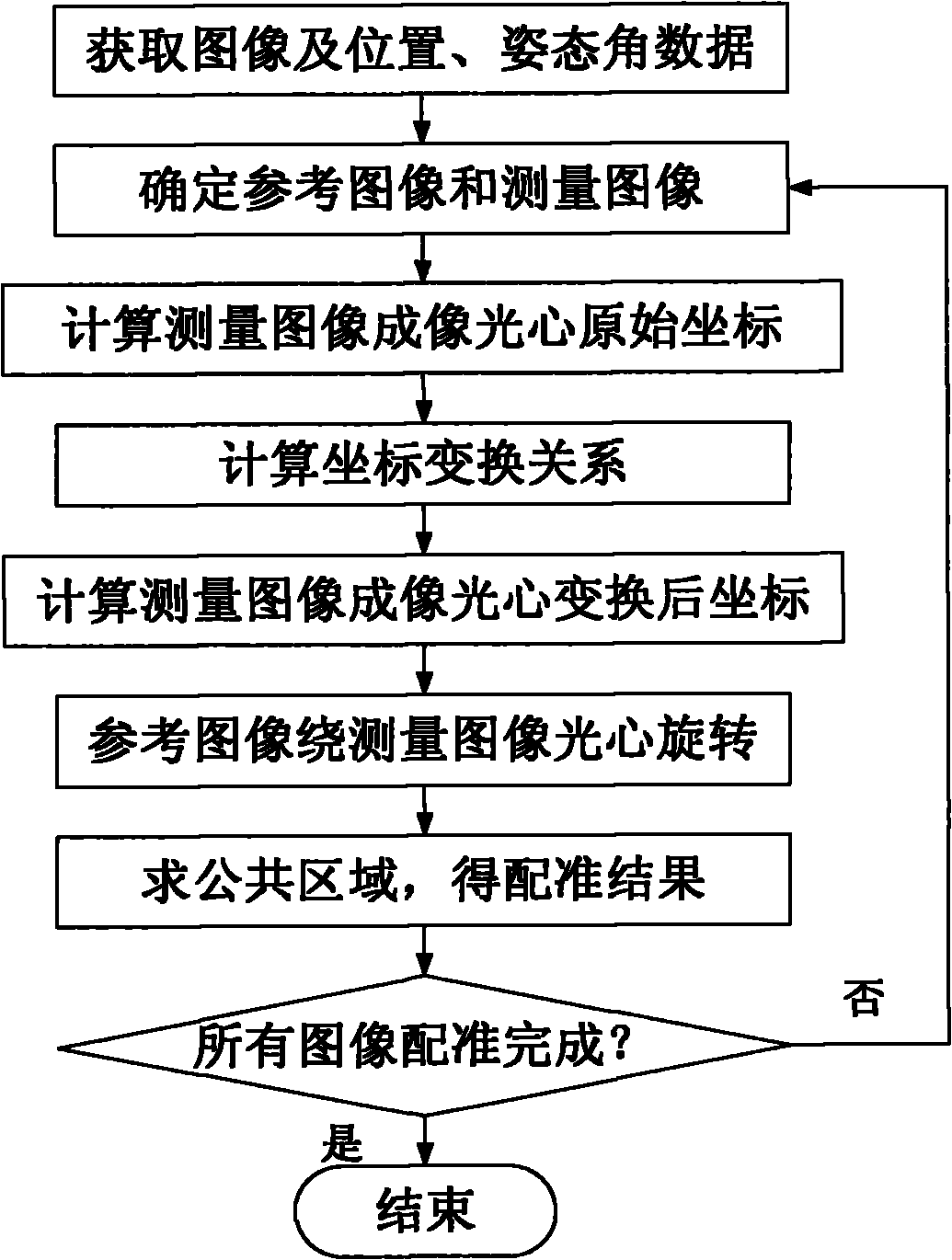
[0027] Now in conjunction with embodiment, accompanying drawing, the present invention will be further described:

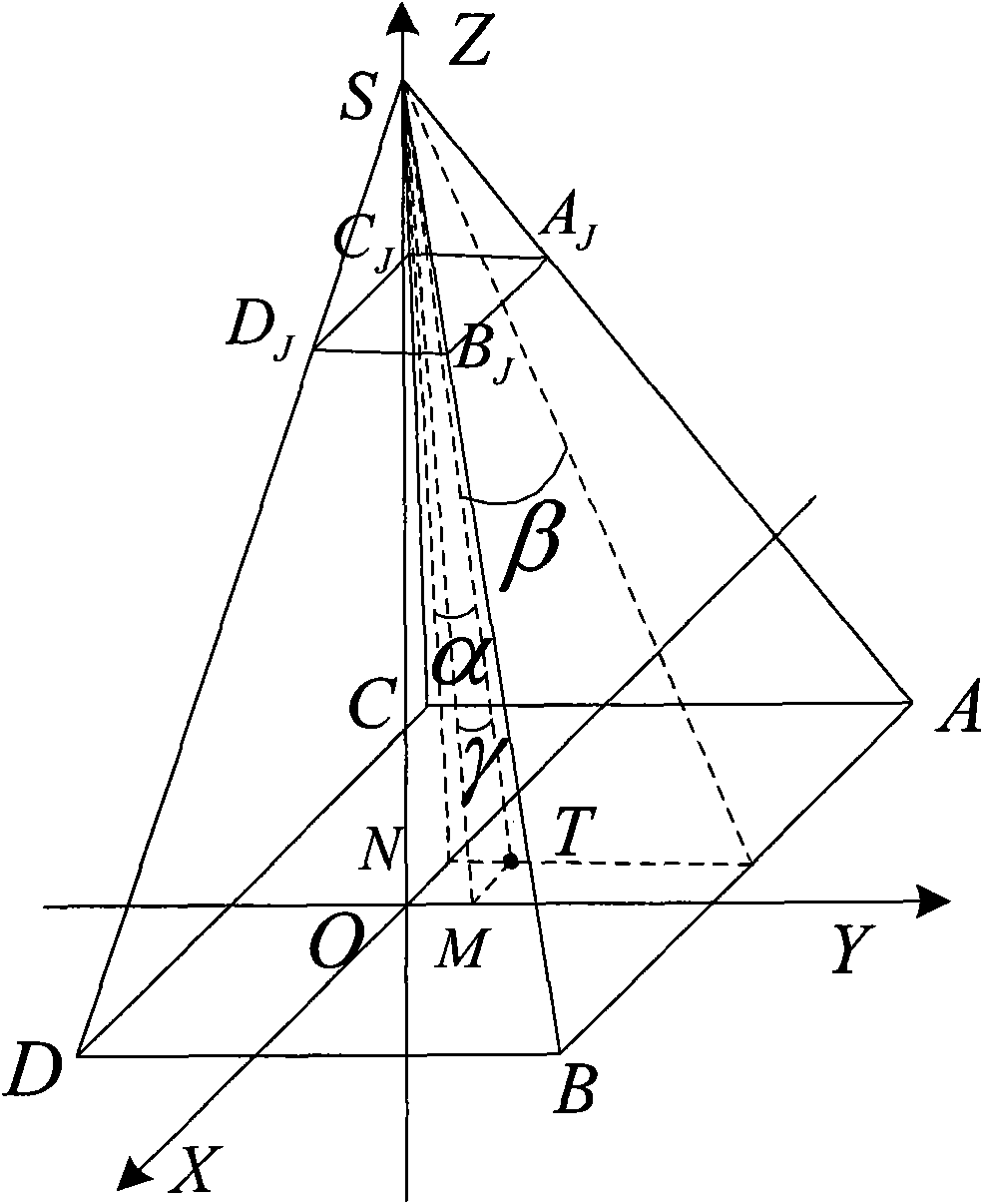
[0028] Step 1. Obtain the original polarized multispectral aerial remote sensing image I i (i=1,...,n) and the three-dimensional position of the camera at the corresponding moment of the image (X c , Y c ,Z c ), attitude angle data (α, β, γ), camera latitude and longitude (L, B), relative ground height H, imaging time and corresponding time imaging data.

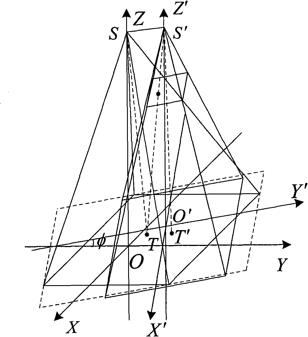
[0029] The imaging coordinate system is defined as: the vertical projection point of the origin O on the camera to the ground plane, the camera movement direction is the Y-axis direction, the line connecting the origin and the camera point is the Z-axis, and the right-handed rectangular coordinate system OXYZ. The local horizontal coordinate system is defined as: the origin is at a certain point in the measurement area (origin O of the imaging coordinate system), the U axis points east along the WGS84 ellips...


PUM


Abstract

The invention relates to an aviation polarization multi-spectrum image registration method, which comprises the following steps of: selecting an image as a reference image from collected original polarization multispectral aerial remote sensing images, according to the hole imaging geometric model, calculating the coordinates of the imaging optical center of a measurement image in the imaging coordinate system of the measurement image and the coordinates of the imaging optical center of a reference image in the imaging coordinate system of the reference image; calculating the coordinates rotation matrix and the translation vector of the imaging coordinates system of the measurement image to the imaging coordinates system of the reference image; calculating the coordinates (u'T, v'T) of the imaging optical center in the imaging plane coordinate system of the reference image; rotating the measurement image around the imaging optical center according to a rotation matrix to ensure that the imaging optical center of the measurement image after rotation is coincide with the imaging optical center of the reference image; and cutting boundary parts of the measurement image beyond the reference image to obtain a registration result. The invention has the advantage that the content of the images does not need to be considered in the process of registration. Besides, the invention is rapid and simple to realize.

Description

technical field [0001] The invention relates to an aerial polarization multispectral image registration method, relates to the technical field of aerial remote sensing, and is the basis for image splicing and scene matching. Background technique [0002] Multispectral images have important applications in fields such as agriculture, forestry, geology, mining, and environmental protection, and are also widely used in the military field to reveal camouflage, enhance target recognition, and discover new targets. The spectral information between multiple bands is added to the multi-spectral image, so it has the incomparable advantages of the single-band image. Polarization images can provide more characteristic information for distinguishing targets, and the polarization characteristics of different targets are quite different, which can detect the relatively stable characteristics of the target itself. [0003] Polarized multispectral images are obtained by cameras installed o...

Claims


Application Information

Patent Timeline
Patent Type & Authority Applications(China)
IPC IPC(8): G01C11/04
Inventor 赵永强程咏梅吴艳茹庄东风
Owner NORTHWESTERN POLYTECHNICAL UNIV
Why Eureka
Try Eureka