Method for map matching with sensor detected objects

A sensor and object technology, used in geographic positioning systems, vehicle navigation, and digital maps, to solve problems such as high position accuracy and backwardness

Inactive Publication Date: 2011-01-19
TELE ATLAS NORTH AMERICA +1
View PDF4 Cites 70 Cited by
  • Summary
  • Abstract
  • Description
  • Claims
  • Application Information

AI Technical Summary

Problems solved by technology

[0011] However, while vehicle navigation devices have gradually improved over time, becoming more accurate, feature-rich, inexpensive, and popular; they still lag behind the ever-increasing demands of the automotive industry; and, in particular, it is expected that future applications will require High location accuracy and even more detailed, accurate and featured maps

Method used


Image

  • Method for map matching with sensor detected objects
  • Method for map matching with sensor detected objects
  • Method for map matching with sensor detected objects

Examples


Embodiment Construction

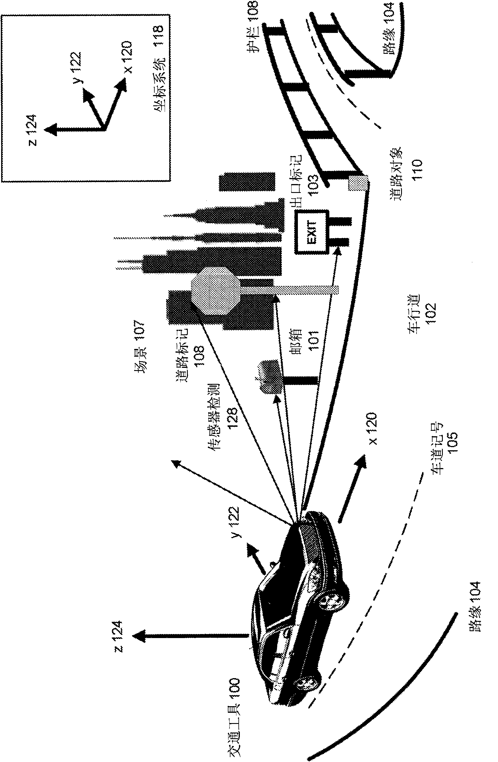
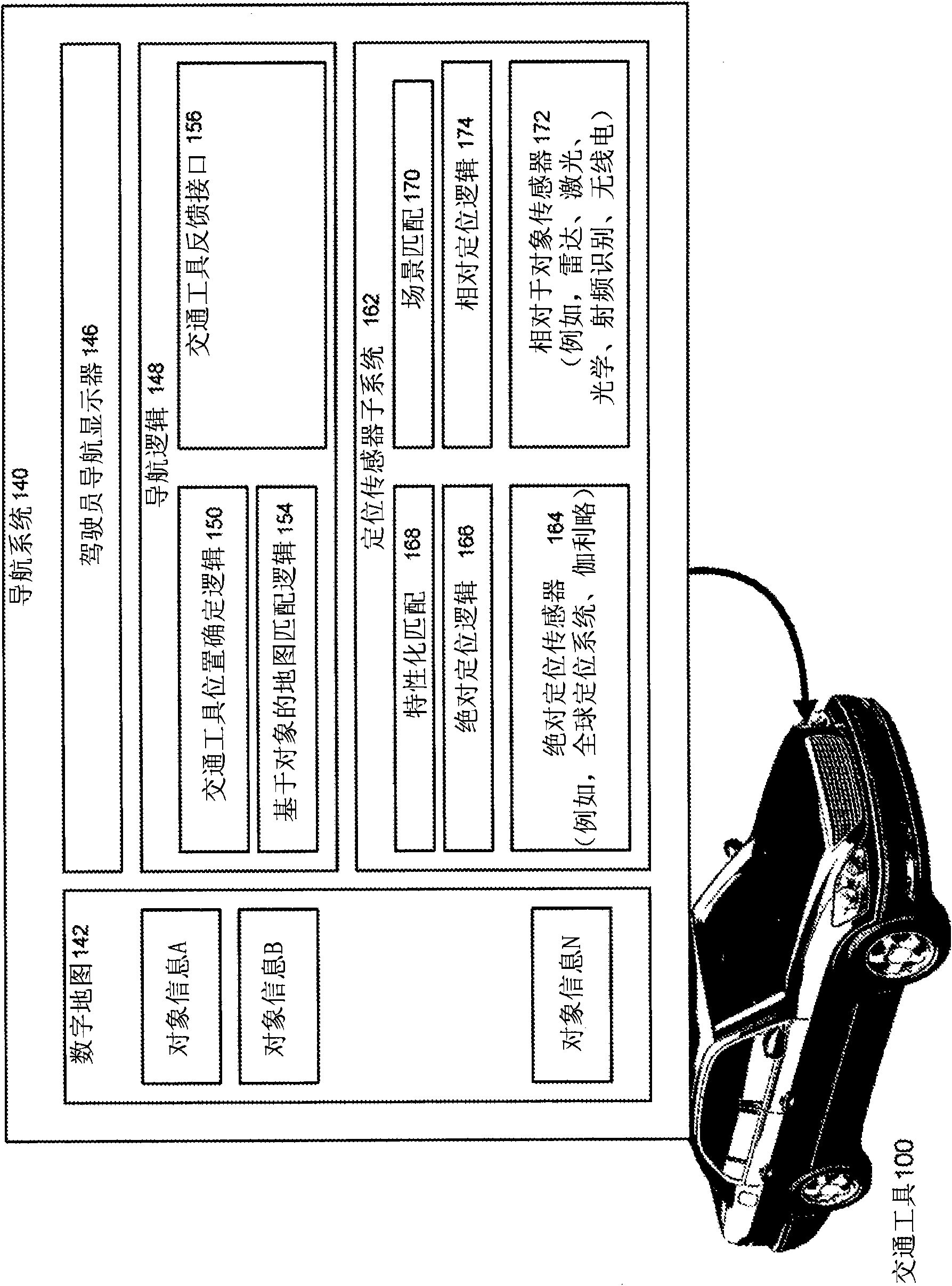
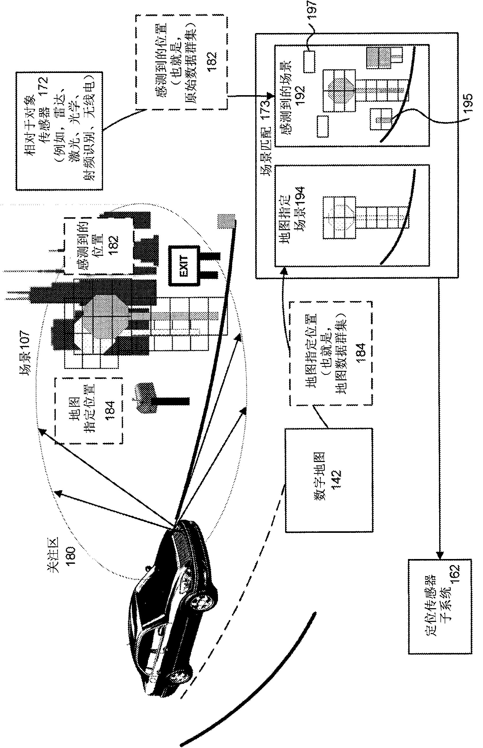
[0029]Described herein is a system and method for map matching with sensor-detected objects. Objects passed by the driver can be disambiguated using direct sensor and object matching techniques. The technique also makes it possible for a navigation system to refine (ie, improve the accuracy of) its position estimate.

[0030] For future navigation-related applications, anticipating a map match to the center of the road may not be sufficient, even when combined with GPS or inertial sensors. A typical roadway with two travel lanes in each direction and a parking lane along each side may be about 20 meters wide. A road centerline is an idealized simplification of a road, essentially having zero width. Inference-based map matching is generally not able to help locate in which particular lane of the road a vehicle is located, or even where a vehicle is located along the road to a high degree of accuracy (say, 5 meters). Today's consumer-level GPS technology may have different so...


PUM


Abstract

Detecting at least one object in the vicinity of a vehicle by a vehicle sensor and estimating characteristics about the object, the sensor being calibrated to the position of the vehicle by e.g. GPS, estimating a location of the sensed object from position and orientation estimates of the vehicle and of the measurements of the sensor; querying a map or image database by vehicle position or estimated sensed object location, the database allowing information to be retrieved for the objects, to extract the objects of the database for that position, comparing the sensed object with the extracted object using a comparison logic, and if such comparison is successful effecting either an adjustment of the GPS position of the vehicle, an adjustment of the position information for the extracted object of the database, or display the extracted, database-depicted object as a graphical image on a display of a navigation unit.

Description

[0001] copyright notice [0002] Portions of the disclosure of this patent document contain copyrighted material. The copyright owner has no objection to the facsimile reproduction by anyone of the patent document or the patent disclosure as it appears in the Patent and Trademark Office patent files or records, but otherwise reserves all copyrights whatsoever. technical field [0003] The present invention relates generally to digital maps, geolocation systems, and vehicle navigation, and more particularly to systems and methods for map matching with sensor-detected objects. Background technique [0004] Over the past few years, navigation systems, electronic maps (also referred to herein as digital maps), and geolocation devices have been increasingly used to provide various navigation functions. Examples of these navigation functions include determining the overall position and orientation of a vehicle; finding destinations and addresses; calculating optimal routes; and ...

Claims


Application Information

Patent Timeline
Patent Type & Authority Applications(China)
IPC IPC(8): G01C21/30
CPCG01S19/48G01S19/49G01S13/86G01C21/30
Inventor 沃尔特·B·扎沃利马尔钦·克米奇克斯蒂芬·齐奥贝尔福尔克尔·希斯特曼
Owner TELE ATLAS NORTH AMERICA
Why Eureka
Try Eureka