Sphere rhombic grid recursive subdivision method

A diamond-shaped and subdivided technology, applied in maps/plans/charts, special data processing applications, instruments, etc., can solve problems such as weak system and practicability, imperfect theoretical system, etc., and achieve the effect of simple conversion

Inactive Publication Date: 2011-02-02
NAT UNIV OF DEFENSE TECH
View PDF1 Cites 12 Cited by
  • Summary
  • Abstract
  • Description
  • Claims
  • Application Information

AI Technical Summary

Problems solved by technology

The global grid based on polyhedron subdivision is a new type of data combination. Although it has some accumulation in scattered fi...

Method used


Image

  • Sphere rhombic grid recursive subdivision method
  • Sphere rhombic grid recursive subdivision method
  • Sphere rhombic grid recursive subdivision method

Examples


Embodiment Construction

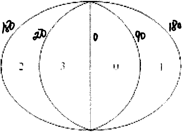
[0053] The present invention provides a new method for recursive subdivision of spherical rhombus grids based on geographical coordinates, using longitude and latitude lines to directly connect the warp and latitude lines with arcs on the spherical surface, and perform 0-n level multi-level recursive rhombus subdivision .

[0054] 1. First perform 0-level segmentation

[0055] The earth is divided into four equal parts by 0°, 90°, 180°, and 270° meridians, and these four equal parts are coded 0, 1, 2, and 3 from east to west starting from the 0° meridian.

[0056] 2. Carry out 1-n level multi-level recursive diamond division

[0057] 3. Encoding each subdivided rhombus sphere

[0058] The boundary of the subdivision unit is closely combined with the latitude and longitude, which makes the conversion between the coding of the subdivision unit and the geographic coordinates relatively easy; The deformation of area and shape is reduced, and subdivision with arbitrary resolutio...


PUM


Abstract

The invention provides a method for directly dividing on sphere by combining meridian and parallel and adopting thinking of regular polyhedron progressive recursion. The method utilizes meridian and parallel, the meridian and parallel are directly connected on sphere by virtue of arc, and multi-stage recursive rhombic dividing is carried out. Firstly 0-stage dividing is carried out, meridians of 0 degree, 90 degrees, 180 degrees and 270 degrees are utilized to divide the earth into four equal parts, and the four equal parts are respectively numbered to be 0, 1, 2 and 3 from east to west from the meridian of 0 degree. Then multi-stage recursive rhombic dividing of 1-n stages are carried out. Each divided rhombic sphere is numbered. The method is operated on sphere directly, no inscribing on the regular polyhedron is required, and no projection is required, thus operation is simple. Random resolution can be realized and seamless zero-overlap global dividing is basically realized.

Description

technical field [0001] This paper proposes a method of combining longitude and latitude and using the idea of ​​regular polyhedron recursion step by step to directly divide the spherical surface. Background technique [0002] At present, GIS is facing great challenges in massive global spatial databases, research on global issues, and location-related information socialization services. The traditional map-based spatial information expression, organization, management and release methods can no longer meet the needs of global spatial information management. With the deepening of space remote sensing application research and theoretical exploration, especially after the "Digital Earth (Digital Earth, DE)" was proposed, the geographic information system (GIS) is not only dealing with the information of a certain local area, but the global Continuous, multi-level, and dynamic environmental resources and social information within the scope, the traditional planar data model has...

Claims


Application Information

Patent Timeline
IPC IPC(8): G09B29/00G06F17/30
Inventor 徐晖孙兆林聂洪山徐欣张玉梅
Owner NAT UNIV OF DEFENSE TECH
Why Eureka
Try Eureka