Geographical map displaying system and method

A display system and map technology, applied in transmission systems, special data processing applications, instruments, etc., can solve the problems of slow network transmission speed, weak concurrency capability, and long processing request response time of map display system, so as to speed up network transmission. Speed, increased speed, effect of solving network concurrency problems

Active Publication Date: 2011-02-09
江西育泊科技有限公司
View PDF0 Cites 8 Cited by
  • Summary
  • Abstract
  • Description
  • Claims
  • Application Information

AI Technical Summary

Problems solved by technology

[0009] The purpose of the embodiments of the present invention is to propose a map display system, aiming at solving the problems of slow

Method used


Image

  • Geographical map displaying system and method
  • Geographical map displaying system and method
  • Geographical map displaying system and method

Examples


Embodiment Construction

[0060] In order to make the object, technical solution and advantages of the present invention clearer, the present invention will be described in further detail below in conjunction with the accompanying drawings and embodiments. For ease of description, only the parts related to the embodiments of the present invention are shown. It should be understood that the specific embodiments described here are only used to explain the present invention, and are not intended to limit the present invention.

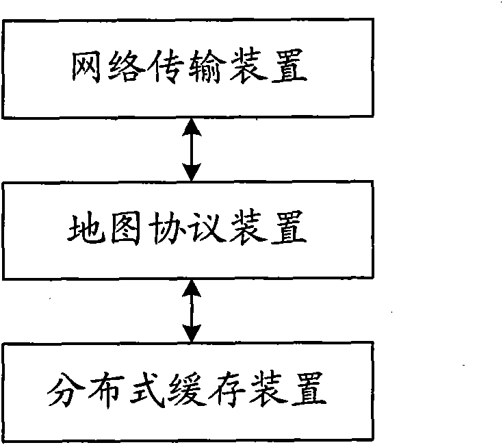
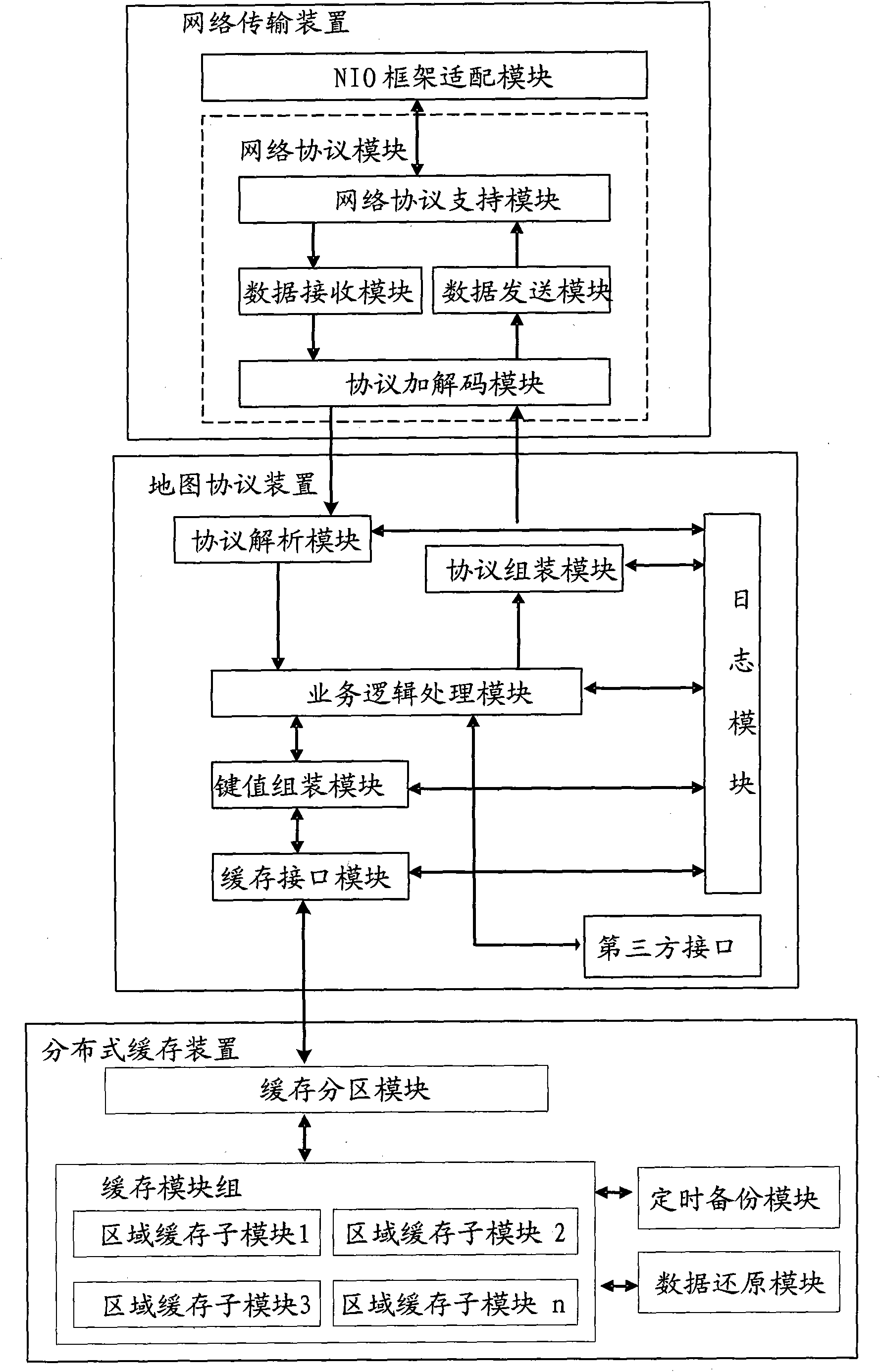
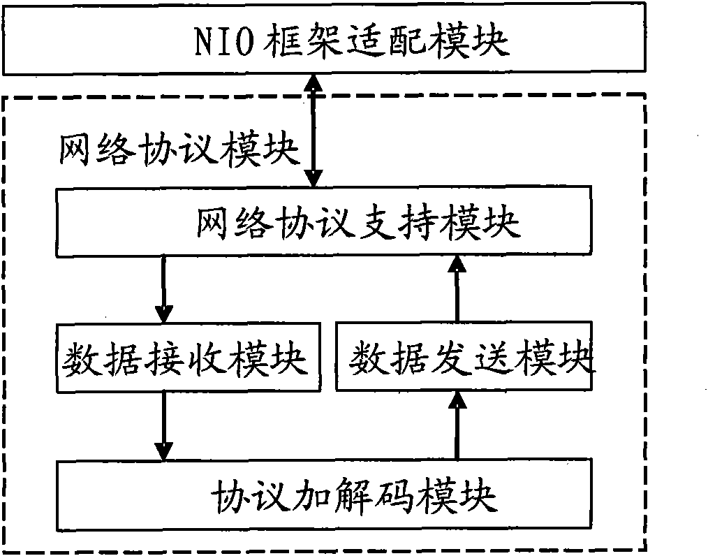
[0061] The invention redesigns and optimizes the network module, logic processing module and data storage module of the traditional map application server system. By implementing the existing NIO framework, the speed of network transmission is accelerated and the problem of network concurrency is solved. At the same time, it supports simple expansion and configuration to adapt to the existing excellent NIO framework, providing scalability for the system; by implementing customizati...


PUM


Abstract

The invention discloses a geographical map displaying system, comprising a network transmission device for NIO frame adaptation, data receiving and sending, data coding/decoding; a geographical map protocol device connected with the network transmission device for analyzing and assembling the protocol, dispensing the protocol, processing the protocol logic and generating the bond value; a distributed buffer device connected with the geographical map protocol device for storing the buffer group, the buffer zone, the buffer backup and the buffer restoring of the geographical map data. The invention accelerates the network transmission speed and solves the network concurrency problem through the existing NIO frame so as to provide the scalability for the system; the invention realizes the user-defined protocol for simplifying the data packet of the request/response and accelerating the speed of the request response; the invention utilizes the feature of the buffer; the data storage structure mainly uses the buffer; and all data can be put in the distributed buffer for accelerating the response time of the processing request.

Description

technical field [0001] The present invention relates to the field of map display, in particular to a map display system and method. Background technique [0002] With the continuous progress of society and the increasingly widespread application of the Internet, location-based services are gradually accepted and popularized by users. With the rapid development of the mobile Internet, positioning applications with different precisions have been realized at present, and users can use GIS-related services through applications in mobile terminals at any time, such as: positioning, bus query, route query and other functions. [0003] The existing mobile Internet map server-side systems can be divided into: map data providers and map application providers. The main businesses they are responsible for are different. Map data providers focus on the development of map data and map engines; while map application providers focus on product application development. [0004] In the pri...

Claims


Application Information

Patent Timeline
IPC IPC(8): H04L29/08G06F17/30
CPCH04L29/08G06F17/30H04L29/06H04L67/02H04L69/16H04L67/568
Inventor 李春雨
Owner 江西育泊科技有限公司
Why Eureka
Try Eureka