Method for comprehensively evaluating casualty loss of link disaster by remote sensing

A disaster and remote sensing data technology, applied in the fields of instruments, climate change adaptation, data processing applications, etc., can solve the problems of single disaster type, poor timeliness of disaster damage assessment, and diverse assessment targets, and achieve the effect of improving timeliness

Inactive Publication Date: 2011-04-06
REMOTE SENSING APPLIED INST CHINESE ACAD OF SCI
View PDF0 Cites 13 Cited by
  • Summary
  • Abstract
  • Description
  • Claims
  • Application Information

AI Technical Summary

Problems solved by technology

[0004] Aiming at the shortcomings of the existing disaster monitoring and evaluation technology, the disaster types are too single, the evaluation targets are too diverse, and the timeliness of disaster damage evaluation is poor, and the invention provides a remote sensing monitoring that can simultaneously carry out flood disasters, landslides and debris flow geological disasters, and quickly identify disasters. Loss targets, and evaluation techniques and methods for disaster losses of multiple hazard-bearing bodies, which facilitate the rapid assessment of multiple hazards, large data volumes, and multiple hazard-bearing bodies

Method used


Image

  • Method for comprehensively evaluating casualty loss of link disaster by remote sensing
  • Method for comprehensively evaluating casualty loss of link disaster by remote sensing
  • Method for comprehensively evaluating casualty loss of link disaster by remote sensing

Examples


Embodiment Construction

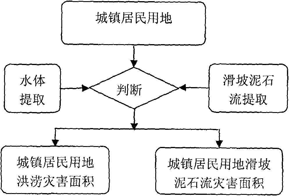
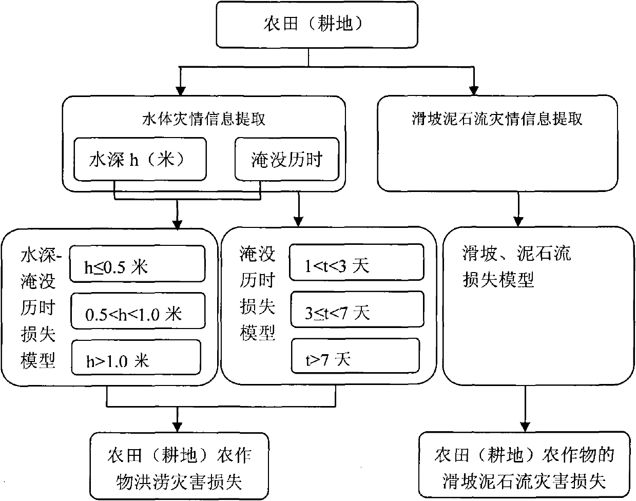
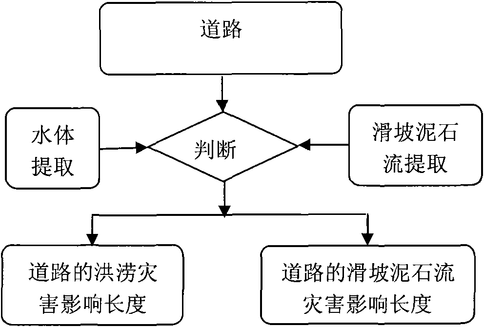
[0020] The technical flow chart of the remote sensing comprehensive evaluation method for catastrophe chain natural disaster disaster loss by using basic geographic data, statistical data and remote sensing data in the present invention is as follows Figure 1 Show. Using this method, the catastrophe chain effect can cause a variety of natural disasters, and the rapid and comprehensive assessment of catastrophe chain disaster losses can be carried out. The specific implementation is as follows:

[0021] ①Disaster target unit

[0022] Disaster loss assessment target data: use human-computer interaction interpretation method to identify and delineate disaster-affected bodies such as farmland (cultivated land), roads, and urban residential land based on the spectrum and texture information of medium and high-resolution data; population data, mainly Use statistical data, land use types, and lighting data to realize spatialization of population data. The target data of disaster ...


PUM


Abstract

The invention discloses a method for comprehensively evaluating the casualty loss of a link disaster by remote sensing. Aiming at the defects of too single disaster type, too diverse evaluation objectives and low timeliness of disaster damage evaluation in the conventional disaster monitoring and evaluation technology, the invention provides a technique capable of monitoring geologic disasters such as flooding and landslide by remote sensing, rapidly recognizing a damage target and evaluating the casualty loss of a plurality of disasters, which contributes to rapid evaluation of a plurality of disaster types, a large amount of data and a plurality of disaster-bearing bodies. Based on the technique for evaluating the casualty loss of the link catastrophe disaster by remote sensing, the method is characterized by comprising the following four units: a disaster target unit, a disaster information extracting unit, a casualty loss model unit and a casualty loss statistical unit. The technique for evaluating the casualty loss by remote sensing consists of the four units and can effectively realize rapid evaluation on the casualty loss of the plurality of disaster types caused by great natural catastrophes.

Description

technical field [0001] It belongs to the technical field of remote sensing monitoring and evaluation of natural disasters. It is specially aimed at the disaster loss evaluation of the disaster chain caused by catastrophe, and realizes the disaster loss evaluation technology of various types of natural disasters. Background technique [0002] With the rapid development of my country's economy and society, the population density increases and the infrastructure expands rapidly, which makes the loss of human life and property caused by natural disasters more serious. Moreover, giant disasters often induce secondary disasters to occur one after another, forming a disaster chain. The destructive intensity of chain disasters is far greater than the simple superposition of various single disaster types, which can cause major losses that endanger the overall situation. For example, the catastrophe chain of the 5.12 Wenchuan Earthquake directly caused major earthquake damage, and cau...

Claims


Application Information

Patent Timeline
Patent Type & Authority Applications(China)
IPC IPC(8): G06Q50/00
CPCY02A10/40
Inventor 阎福礼杜聪王峰韩昱
Owner REMOTE SENSING APPLIED INST CHINESE ACAD OF SCI
Why Eureka
Try Eureka