Multi-scale expression method for semantic-considered overground-underground integrated model

An integrated model, multi-scale technology, applied in the field of geographic information system and geoscience modeling, can solve the problems that hinder the construction and application development of digital city and digital mine digital geotechnical engineering

Inactive Publication Date: 2011-05-11
吴立新 +1
View PDF0 Cites 9 Cited by
  • Summary
  • Abstract
  • Description
  • Claims
  • Application Information

AI Technical Summary

Problems solved by technology

The multi-scale representation of terrain and aboveground landscape has been developed to a certain extent, but the key technologies such as multi-scale modeling and representation of seamless integration of 3D complex spatial object geometry above and below the ground have not yet broken through
The above problems have restricted t

Method used


Image

  • Multi-scale expression method for semantic-considered overground-underground integrated model
  • Multi-scale expression method for semantic-considered overground-underground integrated model
  • Multi-scale expression method for semantic-considered overground-underground integrated model

Examples


Embodiment Construction

[0054] In order to make the description of the content of the present invention clearer, the present invention will be further described in detail below in conjunction with specific embodiments and with reference to the accompanying drawings.

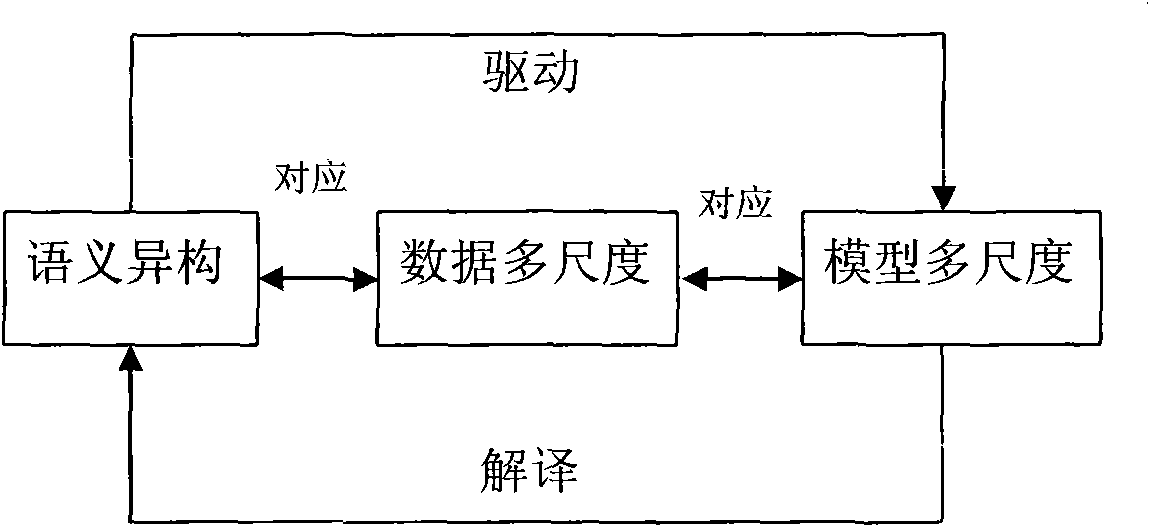
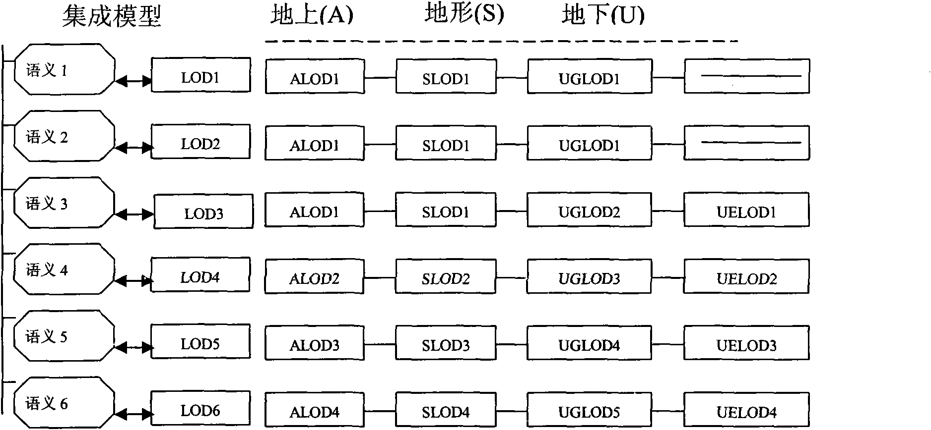
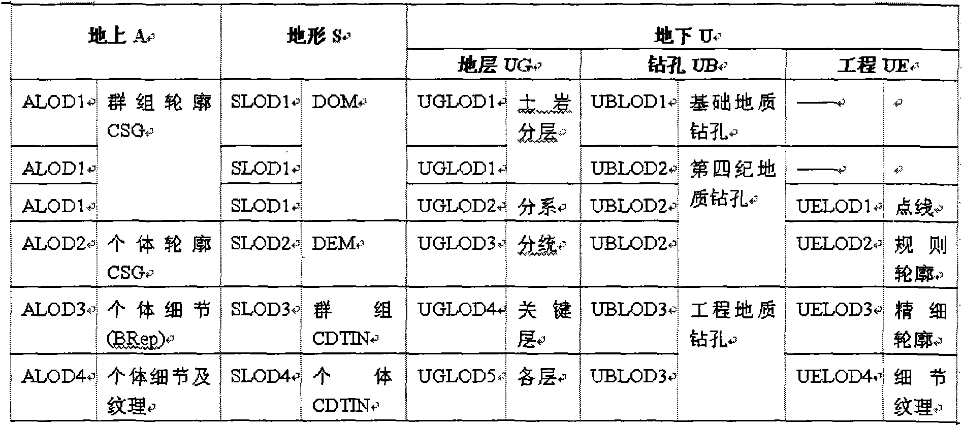
[0055] The multi-scale description of geospatial data in the present invention can be analyzed as follows:

[0056] For the ground space, although remote sensing images can reflect the overall shape and rough outline of an entity, it is difficult to reflect the details of the entity, such as architectural details and internal structures; while the ground site measurement data can more accurately reflect the entity geometry and internal details. Therefore, for the same building, there are two different modes and different scales of data: remote sensing images and ground measurements. For terrain, remote sensing images can be used to superimpose ground control points for simulation expression, and surface measurement points can also be u...


PUM


Abstract

The invention discloses a multi-scale expression method for a semantic-considered overground-underground integrated model, which comprises the following steps of: firstly, considering the semantic heterogeneity of geo-science cognition, and carrying out multi-scale division on geo-science data; then, establishing a corresponding semantic-considered multi-scale model sequence; and finally, constructing an architecture which is multi-scale expressed by an overground-underground seamless integrated model and implementing the architecture. The invention fills in gaps of the multi-scale spatial modeling and expression method for the overground-underground integrated model, satisfies the diversified requirements of the geo-science cognition, forms a complete set of architecture of the geo-science cognition and provides a theoretical basis and a technical scheme for the multi-scale modeling and expression of an overground-underground seamless integrated spatial entity.

Description

Technical field: [0001] The invention relates to the field of geographic information system and geoscience modeling, in particular to a geoscience multi-scale spatial modeling and expression method. Background technique: [0002] With the introduction and strategic implementation of concepts such as "digital mine", "digital city" and "digital geotechnical engineering", seamlessly integrated modeling above and below the ground, as well as spatial analysis and application on it, have become the forefront of the international geoscience field one of the research topics. Multi-scale 3D geoscientific modeling oriented to the seamless integration of ground and ground is an intersecting hotspot among geographic information technology, computer visualization technology and applications in cities, mines and geotechnical engineering. [0003] Due to the different purposes of human beings in exploring the earth's surface and stratigraphic structures, for the same geoscience object or ...

Claims


Application Information

Patent Timeline
IPC IPC(8): G06F17/30
Inventor 吴立新张元生
Owner 吴立新
Why Eureka
Try Eureka