Determination method of imaging condition of agile satellite

A technology for imaging conditions and determination methods, applied in special data processing applications, instruments, electrical digital data processing, etc., can solve the problems of no agile satellite imaging conditions, determination methods, and no basis for agile satellite mission planning

Inactive Publication Date: 2011-05-18
AEROSPACE DONGFANGHONG SATELLITE
View PDF0 Cites 25 Cited by
  • Summary
  • Abstract
  • Description
  • Claims
  • Application Information

AI Technical Summary

Problems solved by technology

At present, although domestic imaging simulation analysis technology has been developed to a certain extent, there is still no method for determining the imaging conditions of agile satellites, and there is no relevant basis for evaluating the quality of satellite imaging. Therefore, there is no basis for agile satellites to follow in mission planning.

Method used


Image

  • Determination method of imaging condition of agile satellite
  • Determination method of imaging condition of agile satellite
  • Determination method of imaging condition of agile satellite

Examples


Embodiment Construction

[0056] The present invention will be further described in detail below in conjunction with the drawings and specific embodiments:

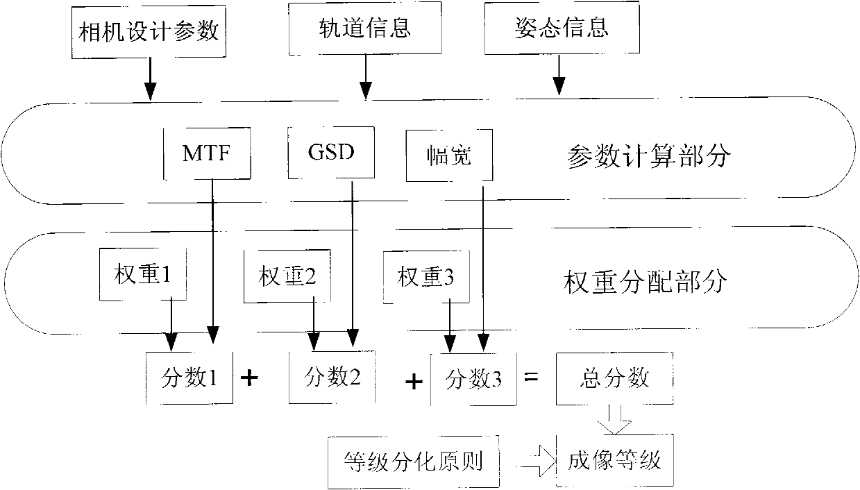
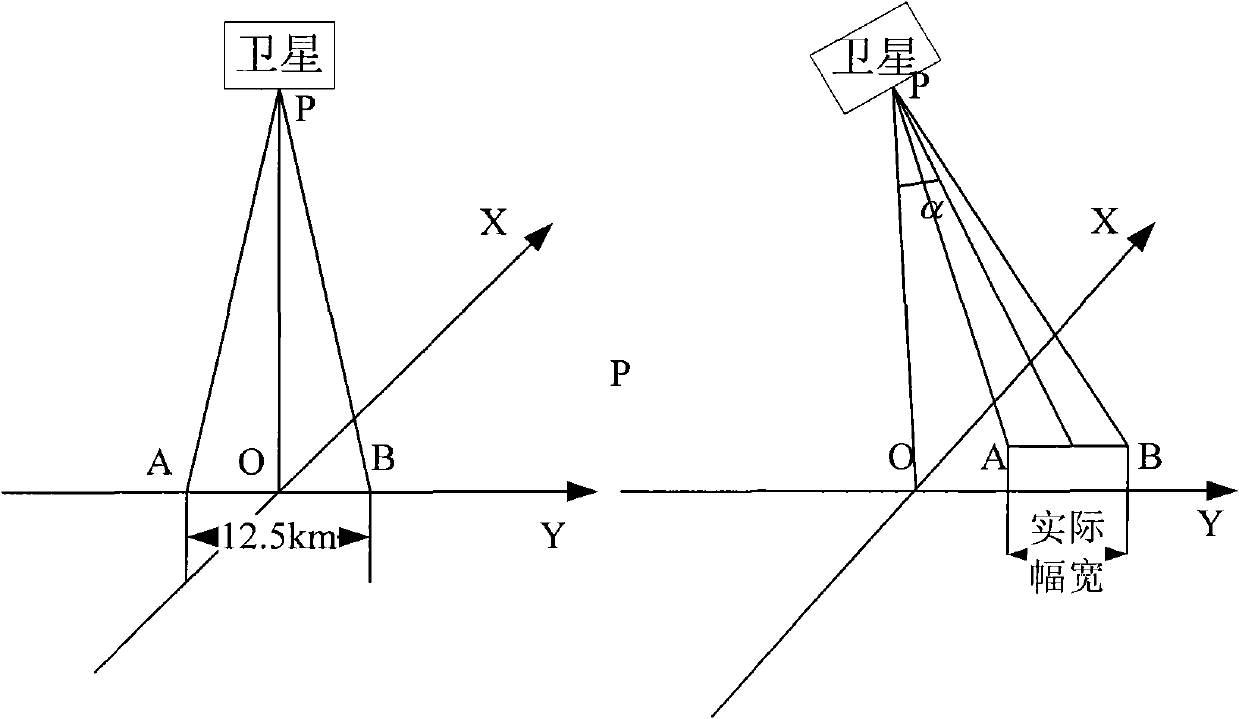
[0057] The agile satellite has four typical imaging modes, including point target imaging, long strip imaging, multi-strip stitching imaging, and co-orbit stereo imaging. According to its design requirements for fast, multi-mode, and high-quality imaging, it is necessary to ensure that the agile satellite can fully consider the impact of imaging conditions on imaging quality during mission planning. When performing corresponding specific imaging tasks in orbit, perform reasonable imaging conditions based on comprehensive imaging conditions. The decision to select the best imaging method and evaluate the imaging effect of this imaging method objectively and quantitatively requires the use of a comprehensive estimation algorithm for application-oriented imaging conditions to make the imaging task comparable to the performance of the agile satellite itse...


PUM


Abstract

The invention discloses a determination method of an imaging condition of an agile satellite, comprising the following steps of: predicting and calculating three classic parameters which are MTF (Modulation Transfer Function), element resolution ratio and imaging width and are used for describing basic attributes, thereby determining the weight ratio accounted by all the parameters in an imaging condition determination system and finally determining the imaging condition of the agile satellite. In the determination method, the influence of imaging conditions of an agile satellite camera under various environments and working modes on imaging quality is considered comprehensively, comprehensive determination is carried out, design verification is carried out by utilizing ground simulation, a concise and objective decision-making basis is provided for a satellite user, meanwhile, the digging condition of specific imaging tasks is reflected to the satellite imaging capability. The determination method is the first comprehensive determination method for the imaging condition of the agile satellite in China, and therefore, the blank on the simulation analysis aspect of the satellite imaging condition in China is filled.

Description

Technical field [0001] The invention relates to a method for determining imaging conditions, in particular to a method for determining imaging conditions of agile satellites. Background technique [0002] Fast and multi-mode high-quality imaging is one of the most distinctive core technologies of agile satellites. The emergence of agile satellites has greatly improved the application capabilities of satellites. However, the imaging quality of satellites is not only affected by the conditions of the satellite platform, but also by its own design. The imaging conditions such as indicators, orbital parameters, space environment and working mode also affect the imaging quality in different aspects and to varying degrees. Therefore, how to reasonably plan satellite missions to achieve the maximum use efficiency and obtain the best imaging quality has become an urgent problem to be solved. Although the imaging simulation analysis technology in China has been developed to some extent, ...

Claims


Application Information

Patent Timeline
Patent Type & Authority Applications(China)
IPC IPC(8): G06F19/00G05D1/08G05D1/10
Inventor 吕大旻侯小瑾杨芳刘胜利谢松
Owner AEROSPACE DONGFANGHONG SATELLITE
Why Eureka
Try Eureka