Galileo system integrity concept-based multimode user integrity assessing method

An integrity and user technology, applied in radio wave measurement systems, satellite radio beacon positioning systems, special data processing applications, etc., can solve the risk of not providing guaranteed user integrity, and cannot truly and objectively reflect the availability of system positioning results , limiting the availability of positioning results, etc.

Active Publication Date: 2011-06-15
CHINA AEROSPACE KEGONG INFORMATION TECH RES INST
View PDF4 Cites 33 Cited by
  • Summary
  • Abstract
  • Description
  • Claims
  • Application Information

AI Technical Summary

Problems solved by technology

But in fact, the failure probability of each batch and each satellite is different, so it cannot be evenly distributed
2) The formula for calculating the horizontal protection limit HPL (Horizontal Protection Limit) based on the Chi-Square is based on a very conservative assumption, that is, some probability of correct detection is included in the probability of missed detection, thereby greatly reducing Availability
3) The integrity risk of the positioning domain is allocated between the horizontal protection limit HPL and the vertical protection limit VPL (Vertical Protection Level) according to a fixed ratio of 1% and 99%.
However, the accuracy of SBAS orbit determination and clock correction is not high, so when the actual data often cannot meet the assumed conditions, SBAS does not provide means to ensure the integrity of the user
2) SBAS has a conservative design problem similar to RAIM, that is, the integrity probability requirements are allocated between the horizontal protection level HPL and the vertical protection level VPL according to a fixed ratio (WAAS according to 2% and 98%)
[0010] To sum up, on the one hand, due to the certain conservatism of the existing system integrity technologies such as SBAS and RAIM, they cannot truly and objectively reflect the availability of system positioning results for users; on the other hand, due to the limited positioning accuracy of single-constellation systems To a certain extent, the availability of positioning results is limited. In the future, with the establishment of BD and Galileo systems, users can choose more constellations, and multi-system compatible receivers will become a development trend in the future, so as to provide users with high-precision positioning services. Integrity assessment for multi-system user positioning solutions will also become a new requirement in the field of high-precision and high-reliability satellite applications

Method used


Image

  • Galileo system integrity concept-based multimode user integrity assessing method
  • Galileo system integrity concept-based multimode user integrity assessing method
  • Galileo system integrity concept-based multimode user integrity assessing method

Examples


Embodiment Construction

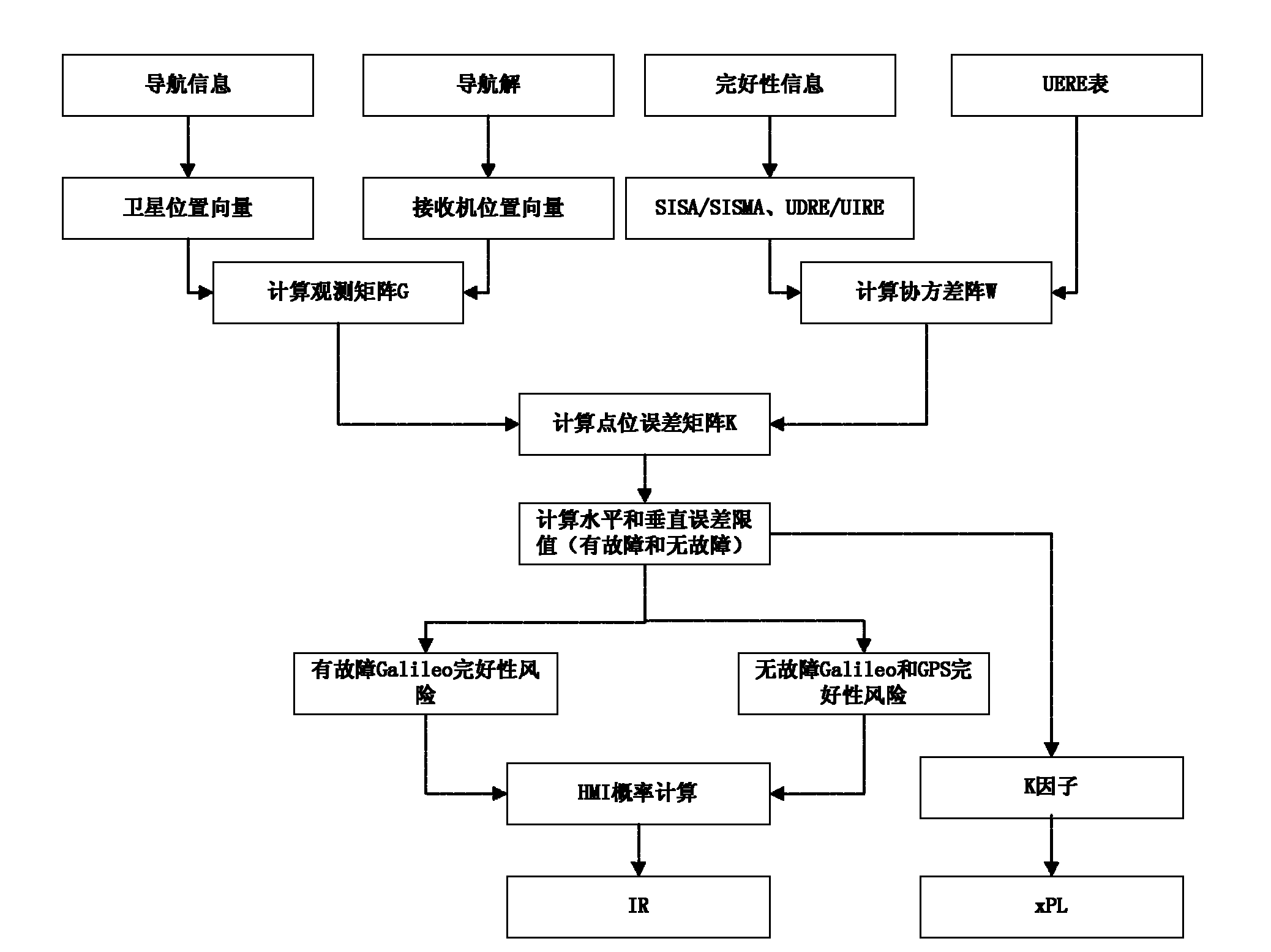
[0123] The technical scheme of the present invention is further described below in conjunction with specific embodiment and accompanying drawing, but it is not limited thereto:

[0124] The multi-mode user integrity evaluation method based on the Galileo system integrity concept provided by the present invention mainly uses the original GPS constellation data downloaded from the IGS website and the simulated GPS integrity data as input of data. The evaluation of multi-mode system integrity requires two parts of data as input, one is Galileo system integrity data SISA, SISMA, and the second is GPS system integrity data UDRE, UIRE. At present, the Galileo system has not been built yet, so SISA and SISMA can only be calculated by using the original GPS data and the calculation method of the integrity parameters of the Galileo system. The integrity evaluation method for the GPS constellation system is relatively mature at present, so there is no system Integrity parameter calculat...


PUM


Abstract

The invention belongs to the field of the integrity study of a satellite navigation system in the technical field of earth observation and navigation, and provides a Galileo system integrity concept-based multimode user integrity assessing method. In the method, the conventional Galileo user integrity concept is used in two systems directly, for a non-Galileo system (such as European geostationary navigation overlay service (EGNOS)), input parameters are needed to be pretreated appropriately, so that the input parameters are converted into information available in a Galileo user integrity algorithm, and the change in values of an integrity risk (IR) and / or a protection level (xPL) is monitored during integrity analysis. In the method, the assessment of multisystem user integrity is realized by using a more advanced Galileo system integrity concept; and by comparing and analyzing integrity calculation results of a single system and a multisystem, the availability of positioning resultsof users is improved substantially under the condition of the multisystem, and the user integrity is improved to a large extent.

Description

technical field [0001] The invention belongs to the field of satellite navigation system integrity research in the field of earth observation and navigation technology, and in particular relates to a multi-mode user integrity evaluation method based on the Galileo system integrity concept. Background technique [0002] The global satellite navigation system currently mainly includes the GPS of the United States, the GLONASS of Russia, and the Galileo of Europe and the BD system of China which are under construction. The corresponding enhancement and integrity technologies are also being gradually developed and perfected. So far, a variety of integrity technologies have been proposed for single-constellation satellite navigation systems, which are mainly divided into three categories from the implementation level: The first is Receiver Autonomous Integrity Monitoring (RAIM), which is the integrity of the terminal level. The second is the satellite-based augmentation system S...

Claims


Application Information

Patent Timeline
Patent Type & Authority Applications(China)
IPC IPC(8): G01S19/23G01S19/33G06F19/00
Inventor 於亮张雪辉贝超刘岩陈雷任晓松
Owner CHINA AEROSPACE KEGONG INFORMATION TECH RES INST
Why Eureka
Try Eureka