Method for dynamically constructing online thematic map

A technology of thematic maps and construction methods, applied in maps/plans/charts, instruments, calculations, etc., can solve the problem of interactive visualization of distributed statistical data without in-depth exploration of statistical indicators and visual variable constraints, and failure to realize online thematic map dynamics Construction and other issues to achieve obvious results

Inactive Publication Date: 2011-07-20
WUHAN UNIV
View PDF4 Cites 30 Cited by
  • Summary
  • Abstract
  • Description
  • Claims
  • Application Information

AI Technical Summary

Problems solved by technology

However, the above-mentioned related patents focus on the release of simple maps of basic geographic elements, and the human-computer interaction method focuses on data expression, without in-depth exploration of

Method used


Image

  • Method for dynamically constructing online thematic map
  • Method for dynamically constructing online thematic map
  • Method for dynamically constructing online thematic map

Examples


Embodiment Construction

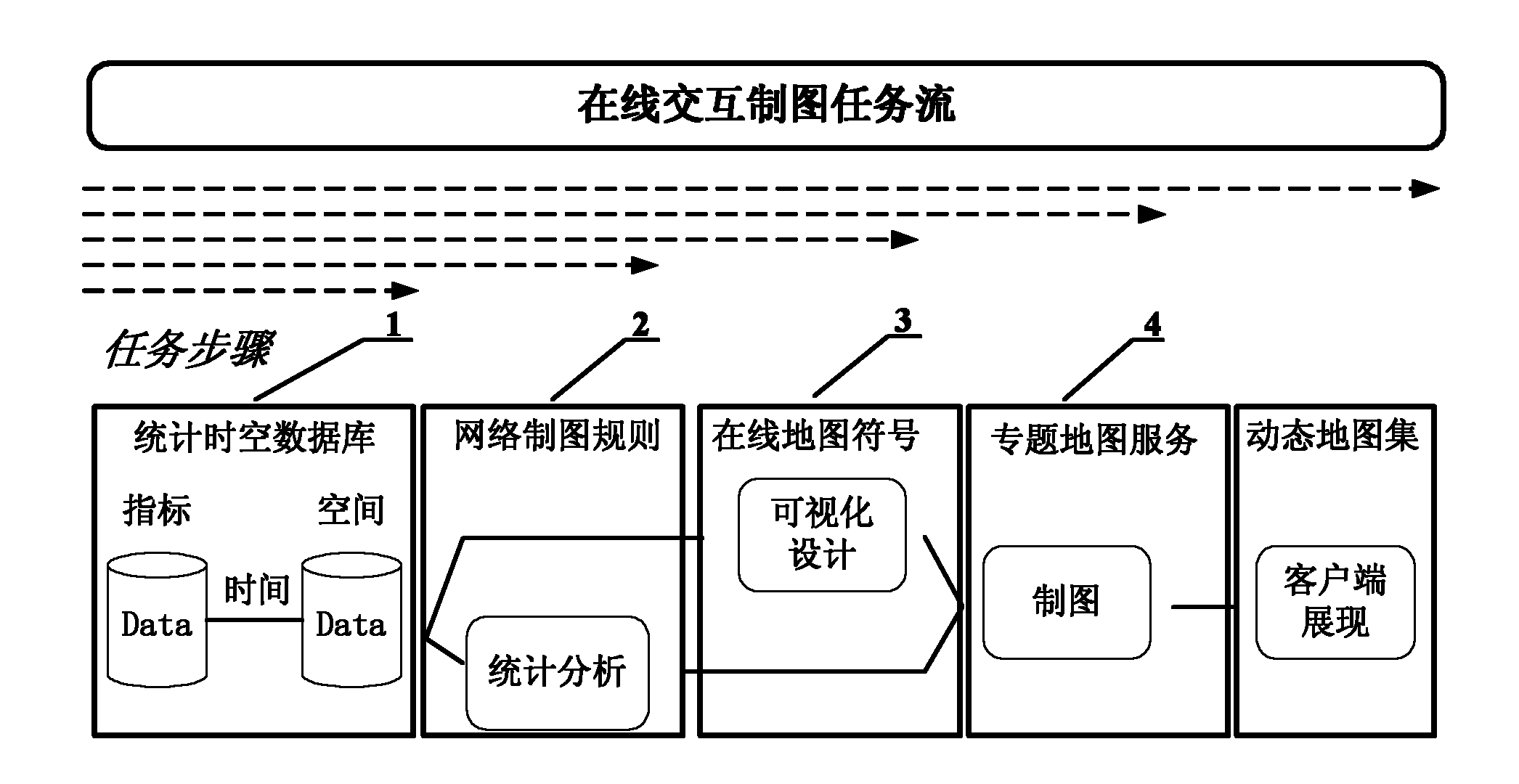
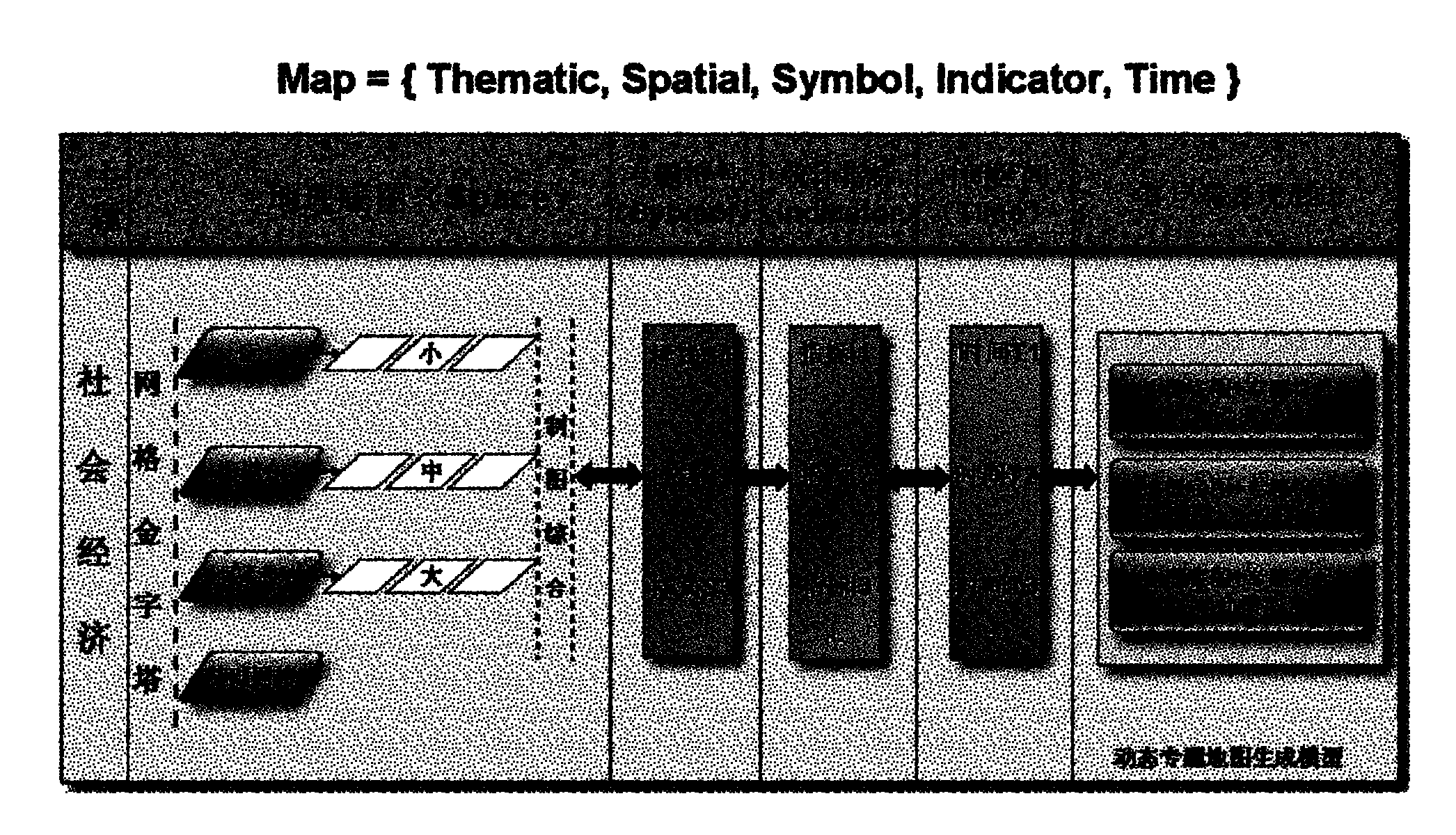
[0038] The invention provides a method for dynamically constructing an online thematic map. Through online organization and dynamic modeling of heterogeneous and heterogeneous distributed statistical index data, a multivariate map drawing method is adopted. First, three statistical indicators, visual variables and map symbols are established. Orderly mapping between sets, and then integrated to form a cartographic rule set with aggregated visual variables as the core feature. Finally, XML is used as a formal description language for network map symbols, and a personalized thematic map is dynamically constructed in the form of network thematic map service combination , and form an online atlas organized by the logical hierarchical model of "map group-map frame-illustration". The present invention takes into account the characteristics of distributed statistical indicators and the multivariable mapping method, constructs a corresponding thematic map symbol formalization system ac...


PUM


Abstract

The invention relates to the technical field of network maps and space information service, in particular to a method for dynamically constructing an online thematic map. The method comprises the following steps of: constructing a sequenced mapping among three sets, namely a statistical index, a visual variable and a map sign by performing online organization and dynamic modeling on heterogeneous distributed statistic index data by a method for drawing a multi-variable map so as to integrate to form a drawing rule set in which a gathering visual variable is used as a core characteristic; and formalizing description language by using extensible markup language (XML) as a network map sign, dynamically constructing a personal thematic map by using a format of a network thematic map service combination, and forming the online thematic map in a logic layer model organization of a map group, a map picture and an illustration, which is detailed step by step. By the method, a map expression acquired by the user comprises dynamic customization expressed in the forms of a map sign, a color and the like, so the humanized requirement of the map user can be fully met; and aiming at users on different levels, the thematic maps meeting the service requirements can be designed, and the effect is remarkable.

Description

technical field [0001] The invention relates to the technical field of network maps and spatial information services, in particular to a method for dynamically constructing online thematic maps. Background technique [0002] In various current electronic map (collection) systems, maps are still "prefabricated", which are pre-designed and stored in the system. The so-called "dynamic" is only reflected in the online customization and personalization of users based on prefabricated limited versions. Maps, these systems are essentially "pre-made" map databases. From the perspective of cartography theory and technology, map drawing and map application are still two independent processes, and the mode of map information transmission has not changed. The traditional map-making technology chain divides multiple stages with clear boundaries between map producers and map users, including map production, carrier transmission, and cognitive analysis. Users can only passively accept exi...

Claims


Application Information

Patent Timeline
IPC IPC(8): G06F17/30G09B29/00
Inventor 任福赵飞杜清运曾兴国
Owner WUHAN UNIV
Why Eureka
Try Eureka