Method and device for simultaneously determining three-dimensional geometry position and gravity potential by utilizing global position system (GPS) signal

A technology of GPS signal and three-dimensional geometry, applied in satellite radio beacon positioning systems, measuring devices, instruments, etc., can solve a lot of manpower, financial resources, heavy leveling, gravity measurement and other problems, and achieve the effect of saving manpower

Inactive Publication Date: 2011-08-10
WUHAN UNIV
View PDF3 Cites 5 Cited by
  • Summary
  • Abstract
  • Description
  • Claims
  • Application Information

AI Technical Summary

Problems solved by technology

[0003] The present invention mainly solves the need for heavy leveling and gravity measurement in the prior art, or needs to determine the geoid in advance and then use the GPS positioning method to determine the altitude. Technical problems such as great limitations; provide a method that does not require heavy leveling and gravity measurement, and does not

Method used


Image

  • Method and device for simultaneously determining three-dimensional geometry position and gravity potential by utilizing global position system (GPS) signal
  • Method and device for simultaneously determining three-dimensional geometry position and gravity potential by utilizing global position system (GPS) signal
  • Method and device for simultaneously determining three-dimensional geometry position and gravity potential by utilizing global position system (GPS) signal

Examples


Embodiment

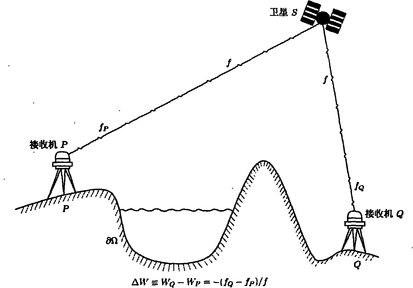
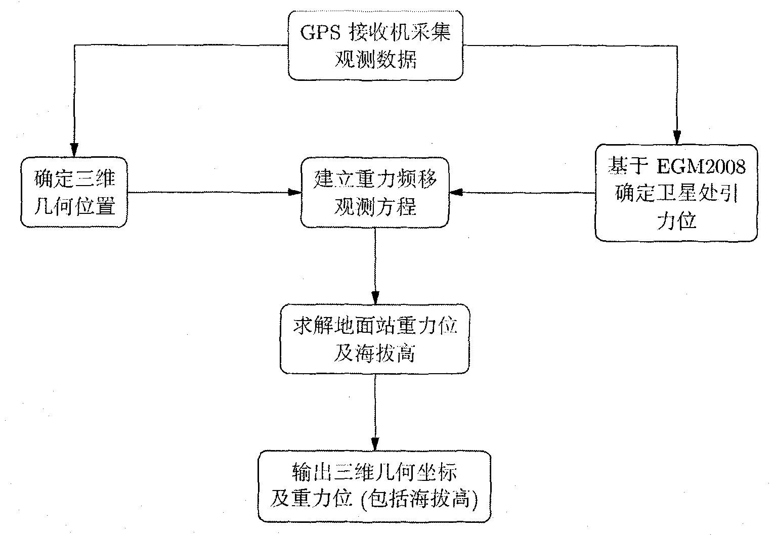
[0029] A method for simultaneously determining a three-dimensional geometric position and a gravity position using a GPS signal, comprising the following steps:

[0030] Step 1, use the GPS receiver to collect and observe the phase and signal frequency shift observation values ​​of at least 4 satellites that last for at least 20 minutes. The sampling rate of the observation values ​​is 1 second, and each observation value corresponds to an observation time;

[0031] Step 2, the three-dimensional geometric position determination module utilizes the phase observation value and the precise ephemeris in step 1 to determine the three-dimensional geometric position of the ground station;

[0032] Step 3, using the EGM2008 gravity field model and the precise ephemeris to determine the gravitational position of the GPS satellite at the moment corresponding to the observed value by the satellite gravitational position determination module;

[0033] Step 4, the three-dimensional geometr...


PUM


Abstract

The invention relates to a method and a device for simultaneously determining three-dimensional geometry position and gravity potential, in particular to a method and a device for simultaneously determining the three-dimensional geometry position and the gravity potential by utilizing a global position system (GPS) signal. In the technical scheme, a novel method for determining the gravity potential (including elevation height) by utilizing the GPS signal is added on the basis of the traditional GPS positioning method, an observation equation between the GPS signal and the gravity potential is established, and the gravity potential is solved on the basis of a principle of least square by utilizing multiple observation data. The invention has the advantages that: heavy water level measurement and gravity measurement are not needed, and the geoidal surface is not needed to be pre-determined to determine the elevation height by utilizing the GPS positioning method, so that numerous laborpower and financial resources are saved, and the restriction on measurement caused by mountains and cross oceans is avoided.

Description

technical field [0001] The invention relates to a method and device for simultaneously determining three-dimensional geometric position and gravity position, in particular to a method and device for simultaneously determining three-dimensional geometric position and gravity position by using GPS signals. Background technique [0002] The use of GPS signals to determine the three-dimensional geometric position is a very mature technology. In order to determine the gravity position or altitude, according to the traditional method, heavy leveling and gravity measurement are required, or the geoid needs to be determined in advance and then the GPS positioning method is used to determine the altitude, which not only requires a lot of manpower and financial resources, but also in mountainous areas are greatly restricted. Since the GPS signal contains three-dimensional geometric position information, the three-dimensional geometric position can be determined, which is a very matur...

Claims


Application Information

Patent Timeline
IPC IPC(8): G01S19/42G01C5/00
Inventor 申文斌冯延明
Owner WUHAN UNIV
Why Eureka
Try Eureka