Mobile terminal location data caching and real-time updating system and method

A mobile terminal and data caching technology, applied in the field of satellite positioning and navigation, can solve the problems of limiting the number of simultaneous online users of the system and the large amount of terminal location data, and achieve the effect of reducing the amount of data transmission and ensuring real-time updates.

Active Publication Date: 2011-08-31
亿海蓝(北京)数据技术股份公司
View PDF3 Cites 12 Cited by
  • Summary
  • Abstract
  • Description
  • Claims
  • Application Information

AI Technical Summary

Problems solved by technology

If the client monitors a large number of terminals, each time the background server responds to the latest location data request from the client, the amount of terminal location data that need

Method used


Image

  • Mobile terminal location data caching and real-time updating system and method
  • Mobile terminal location data caching and real-time updating system and method
  • Mobile terminal location data caching and real-time updating system and method

Examples


Embodiment Construction

[0043] The specific embodiments of the present invention will be described in further detail below with reference to the accompanying drawings and embodiments. The following examples are intended to illustrate the present invention, but not to limit the scope of the present invention.

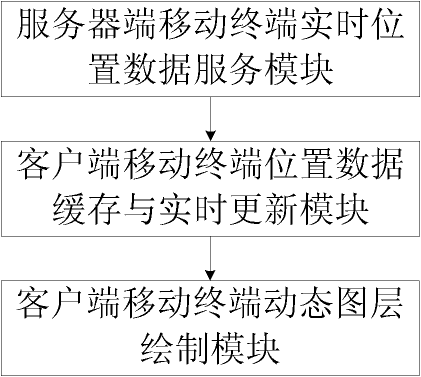
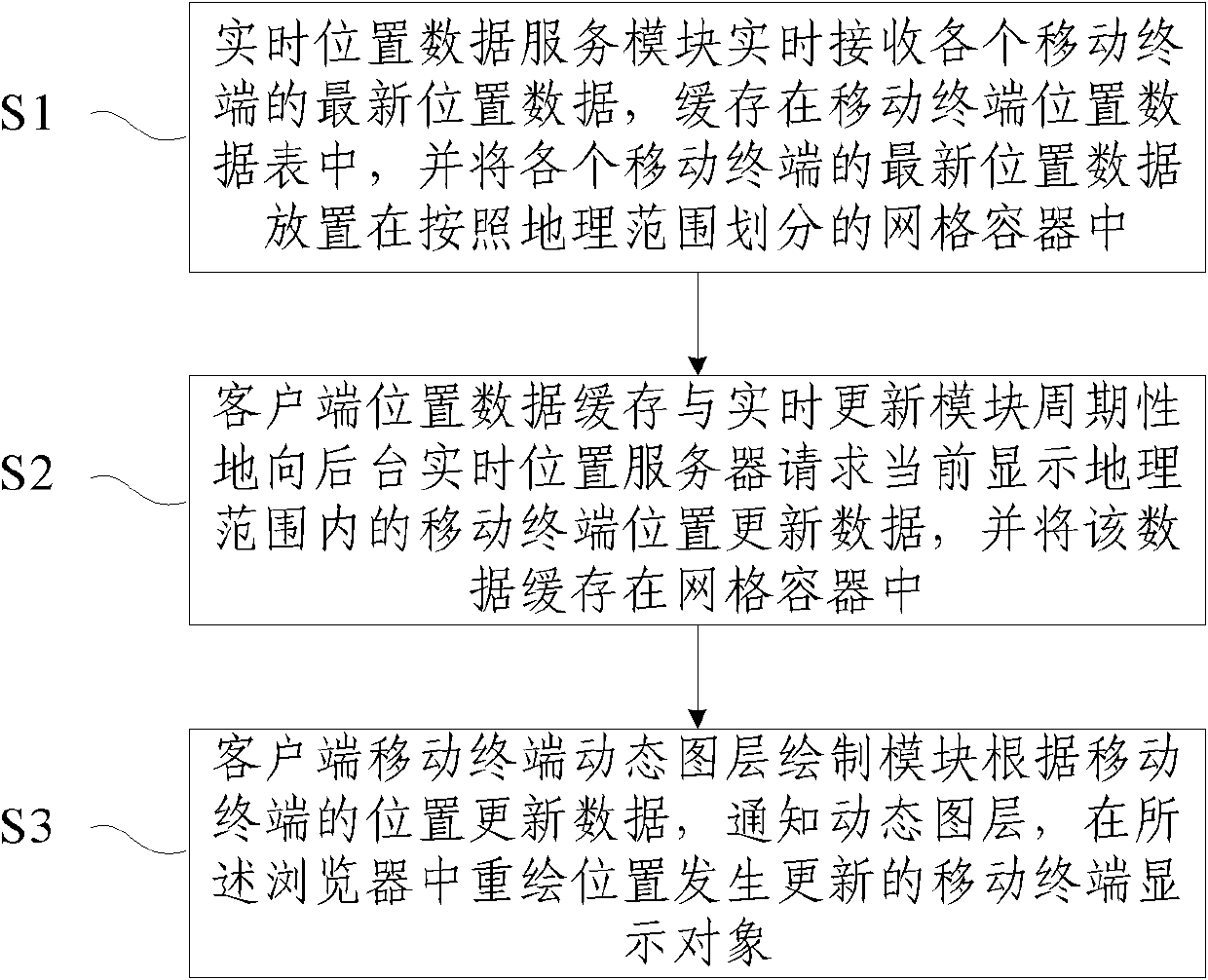
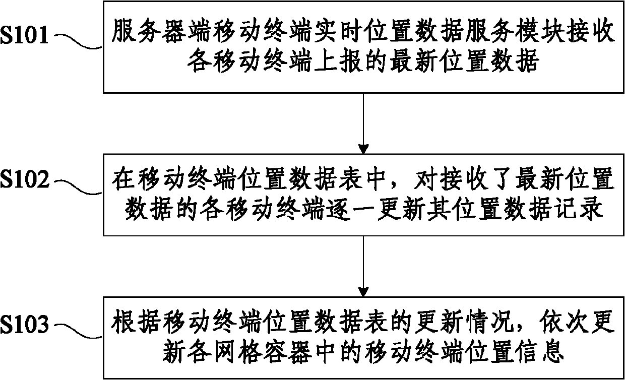
[0044] Aiming at the WebGIS system, the present invention proposes a grid management and incremental update technology for the location data of mobile terminals, so as to realize the efficient update and real-time monitoring of the location of a large number of mobile terminals, so as to effectively reduce the data transmission between the client and the location server. This ensures that a large number of client users can browse multiple mobile terminals online at the same time.

[0045]In the WebGIS system, the real-time monitoring of the mobile terminal is achieved through the client continuously (with a fixed time interval, periodically) requesting the latest location data of the monitored ...


PUM


Abstract

The invention discloses a mobile terminal location data caching and real-time updating system and a mobile terminal location data caching and real-time updating method. A server real-time location service saves and manages the latest location data of all mobile terminals by taking a grid container as a unit; a client caches terminal location data obtained from a background server also by taking the grid container as the unit, and attaches the latest updating timestamps to each grid container respectively; and the client transmits a request to a location server to acquire terminal location updating data in each grid in a currently displayed boundary to realize the incremental updating of the terminal location data cached by the client by taking the grid as the unit. By the terminal-location-data-grid-based management and incremental updating technology, the real-time updating of mobile terminal locations in the display range of a map is ensured, data traffic between the client and the location server is effectively reduced, and the needs of a plurality of client users in the simultaneous online browsing of a plurality of mobile terminals are satisfied.

Description

technical field [0001] The invention relates to the field of satellite positioning and navigation, in particular to a system and method for caching and real-time updating of mobile terminal position data for a client in a WebGIS system. Background technique [0002] In the field of satellite positioning and navigation, real-time position monitoring of a large number of mobile terminals is required, such as a ship position monitoring system at sea or a vehicle monitoring system on land. The location monitoring system needs to maintain the real-time update and display of the location data of the mobile terminal on the client side of the WebGIS (WebGIS: Internet-based Network Geographic Information System) platform. [0003] Existing mainstream WebGIS systems are all based on B / S (Brower / Server, browser / server) architecture and rely on client browsers to achieve cross-platform support for various client environments. The client is based on Web scripting technologies such as Ja...

Claims


Application Information

Patent Timeline
IPC IPC(8): H04W8/24H04W24/00H04L29/06
Inventor 丁必为李同堂杨小进裴小平丰晓军蔡志明
Owner 亿海蓝(北京)数据技术股份公司
Why Eureka
Try Eureka