A gis database incremental update method and its system

An incremental update and database technology, applied in the field of geographic information systems, can solve problems such as insecurity, inability to incrementally update information transmission, increase manpower and transportation costs, etc., and achieve the effect of small data volume

Active Publication Date: 2017-08-25
NAT GEOMATICS CENT OF CHINA
View PDF3 Cites 0 Cited by
  • Summary
  • Abstract
  • Description
  • Claims
  • Application Information

AI Technical Summary

Problems solved by technology

This patent and all the incremental update methods currently retrieved, all the incremental information recorded in it is the spatial coordinates and attributes of geographic elements, which are state secrets. The current bottleneck problem is the large amount of transmitted data and insecure transmission. After the main database data is updated, it is impossible to transmit the incremental update information to the customer database through the network to complete the synchronous update of the customer database. The current method is to manually transfer the data by using a dedicated storage medium, which is not safe, wastes time, and increases manpower and transportation costs

Method used


Image

  • A gis database incremental update method and its system
  • A gis database incremental update method and its system
  • A gis database incremental update method and its system

Examples


Embodiment 1

[0037]The GIS database incremental update method described in this embodiment is used to update the first GIS data in the first computer to the second GIS data through the second computer, wherein the first computer and the second computer It is the same computer, but the first GIS data and the second GIS data are GIS data stored in different locations, but their data and versions need to be the same.

[0038] When the first computer and the second computer are not the same computer, it is required that the display screens of the two computers have the same size and resolution as far as possible.

[0039] At the same time, it is necessary to require the second computer to use the same software and its version when updating the GIS data, such as GIS editing software, GIS database processing software, and the like.

[0040] The specific methods of this embodiment include:

[0041] The first step is to synchronously record the operation process data when the first computer updat...

Embodiment 2

[0053] The GIS database incremental updating method of the present invention is used for updating the first GIS data in the first computer to the second GIS data through the second computer. In this embodiment, by updating the GIS data of the GIS database of the field computer in the field computer, and updating the computer where the database needs to be updated to the database that needs to be updated as an example, to illustrate the realization of incremental update of the GIS database Methods.

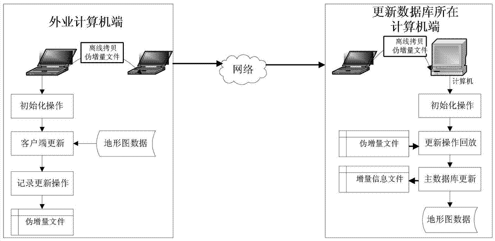
[0054] The schematic diagram of the GIS database incremental update method described in this embodiment is as follows figure 1 As shown, in a preferred implementation of this embodiment, the GIS database incremental update method includes:

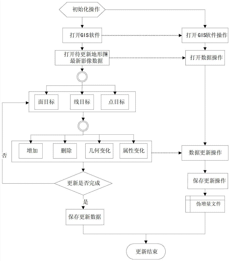
[0055] The schematic diagram of the specific method of starting the update operation record program on the field computer is as follows: figure 2 shown. Open the old version of the vector map data that needs to be updated, including the top...

Embodiment 3

[0096] According to the same idea of ​​the present invention, the present invention also provides a GIS database incremental update system. The GIS database incremental updating system of the present invention is used to update the first GIS data in the first computer to the second GIS data through the second computer. In this embodiment, by updating the GIS data in the GIS database of the field computer in the field computer, and updating the computer where the database needs to be updated to the database that needs to be updated as an example, to illustrate the realization of GIS database increment Updated system implementation.

[0097] The structural block diagram of the GIS database incremental update system described in this embodiment is as follows Figure 4 As shown, in a preferred implementation of this embodiment, the GIS database incremental update system includes:

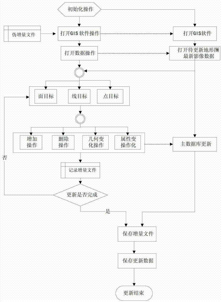
[0098] The pseudo-incremental file acquisition module 401 is used to open the GIS editing software...


PUM


Abstract

The invention discloses a method and system for incrementally updating a GIS (Geographic Information System) database. The method includes: S1. According to the order of operations, synchronously record the operation process when the first computer updates the first GIS data Data; S2. Store the pseudo-increment file in the second computer. When the size or resolution of the display screen of the second computer is different from that of the first computer, the pseudo-increment file in the pseudo-increment file Adaptive modification of the location information; S3. According to the pseudo-increment file in the second computer, automatically drive the second computer to update the second GIS data. The invention solves the problem of GIS database incremental update and its efficient and safe delivery by recording and transmitting various operations of data update without recording the data itself.

Description

technical field [0001] The invention relates to the technical field of geographic information systems, in particular to a method for incrementally updating a GIS database and a system thereof. Background technique [0002] Effective and continuous updating of large-scale geographic information is a worldwide problem. It is to use multi-source current situation data to update and process existing geographic information data bodies through difference comparison, change extraction and measurement, so as to more accurately reflect and express the realistic distribution and spatial characteristics of the objective world. [0003] Master database update can be divided into two modes: batch update and incremental update. Batch update is to directly update the main database, including adding new targets, deleting targets that no longer exist, generating new database versions, saving historical data, etc. During this process, update information is not saved separately. This method ...

Claims


Application Information

Patent Timeline
Patent Type & Authority Patents(China)
IPC IPC(8): G06F17/30
Inventor 刘万增陈军赵勇周晓光林艳刘冬冬
Owner NAT GEOMATICS CENT OF CHINA
Why Eureka
Try Eureka