Radar satellite remote sensing coal-exploration method

A technology of satellite remote sensing and radar, applied in the direction of radio wave reflection/re-radiation, measuring devices, instruments, etc., can solve the problems of low efficiency and high cost, achieve high efficiency, low cost, and improve the success rate

Active Publication Date: 2011-09-07
CHNA ENERGY INVESTMENT CORP LTD +1
View PDF2 Cites 8 Cited by
  • Summary
  • Abstract
  • Description
  • Claims
  • Application Information

AI Technical Summary

Problems solved by technology

[0011] The main purpose of the present invention is to provide a method for finding coal by radar satellite remote s

Method used


Image

  • Radar satellite remote sensing coal-exploration method
  • Radar satellite remote sensing coal-exploration method
  • Radar satellite remote sensing coal-exploration method

Examples


Embodiment Construction

[0024] It should be noted that, in the case of no conflict, the embodiments in the present application and the features in the embodiments can be combined with each other. The present invention will be described in detail below with reference to the accompanying drawings and examples.

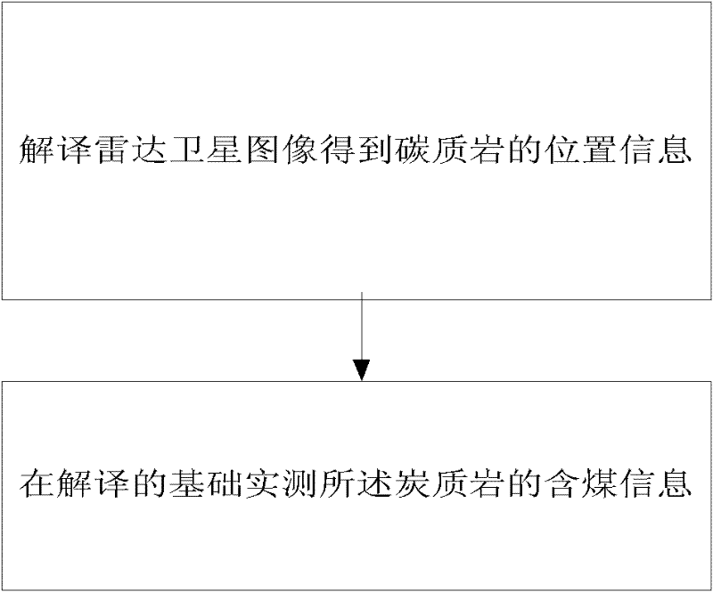
[0025] figure 1 It is the main flow chart of a radar satellite remote sensing coal prospecting method according to the embodiment of the present invention, see figure 1 As shown, the method includes interpreting the radar satellite image to obtain the position information of the carbonaceous rock, and actually measuring the coal-bearing information of the carbonaceous rock on the basis of the interpretation.

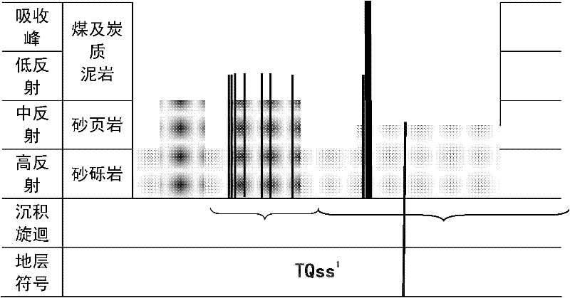
[0026] In the step of interpreting the radar satellite image to obtain the location information of the carbonaceous rock, the radar satellite image can choose clouds, fog, rain, and vegetation that can penetrate the tropical rainforest, so that it can directly reflect the electromagnetic...


PUM


Abstract

The invention provides a radar satellite remote sending coal-exploration method which comprises the following steps: interpreting a radar satellite image to obtain the position information of a carbonaceous rock;, and actually measuring the coal-containing information of the carbonaceous rock on the basis of interpretation. Compared with the prior art, the radar satellite remote sending coal-exploration method has the beneficial effects that a microwave (radar) waveband can penetrate through the cloud, fog, rain and forest in the tropical rain forest, the radar satellite data image can directly reflect the surface geological condition in the tropical rain forest to initially interpret the radar satellite data so as to determine a regional geological structure and the distribution range of the coal-containing rock system; and a remote sensing coal-exploration work region is determined according to the distribution range of the coal-containing system, the blindness of selecting the geological coal-exploration region is prevented, the coal-exploration risk is avoided, and the success rate of exploring new coal fields is greatly improved.

Description

technical field [0001] The invention relates to a method for finding coal by radar satellite remote sensing. Background technique [0002] The ore prospecting method adopted in the tropical rainforest is: establish a living and helicopter base in the tropical rainforest, geologists enter the tropical cloud forest by helicopter, carry out ground crossing, rely on GPS positioning, and carry out ground geological survey and coal prospecting work . Observation technology in the rainforest uses a large number of geological observation points, and compiles geological maps after returning to the base to study the preservation status and occurrence of coal resources. But the existing prospecting method has the following defects: [0003] (1) Technical aspects [0004] 1. The success rate of blindly prospecting and discovering new coal fields is low. Because the vegetation coverage of the tropical rain forest is very dense, it is not clear where there are mines in the selected wo...

Claims


Application Information

Patent Timeline
IPC IPC(8): G01V3/12G01S7/41G01S13/89
Inventor 管海晏孟淑英吴查查樊新杰苏新旭刘向阳宋继华于涛李军刘泽建
Owner CHNA ENERGY INVESTMENT CORP LTD
Why Eureka
Try Eureka