Quick positioning method and device

A positioning method and fast technology, applied in the field of navigation, can solve the problems of being easily affected by factors such as the external environment, small amount of data, and low positioning accuracy, and achieve the effects of narrowing the positioning range, reducing computing costs, and high-precision and fast positioning

Active Publication Date: 2011-10-05
BEIJING UNIV OF POSTS & TELECOMM +1
View PDF3 Cites 21 Cited by
  • Summary
  • Abstract
  • Description
  • Claims
  • Application Information

AI Technical Summary

Problems solved by technology

[0003] Traditional positioning usually uses the handheld terminal to receive the positioning information, and directly calculates the position information through the built-in calculation module. This positioning method has a small amount of data, but the positioning accuracy is low, and it is easily affected by factors such as the external environment; With the development of high-precisio

Method used


Image

  • Quick positioning method and device
  • Quick positioning method and device
  • Quick positioning method and device

Examples


Embodiment 1

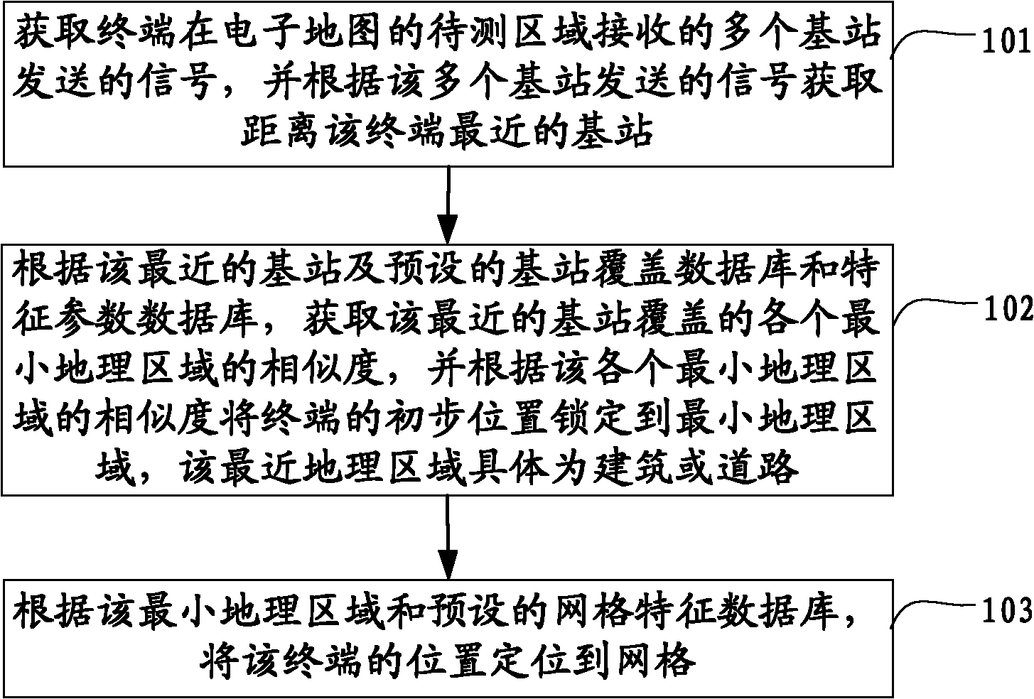
[0053] see figure 1 , the embodiment of the present invention provides a fast positioning method, which specifically includes:

[0054] Step 101: Obtain signals sent by multiple base stations received by the terminal in the area to be tested on the electronic map, and obtain the nearest base station to the terminal according to the signals sent by the multiple base stations;

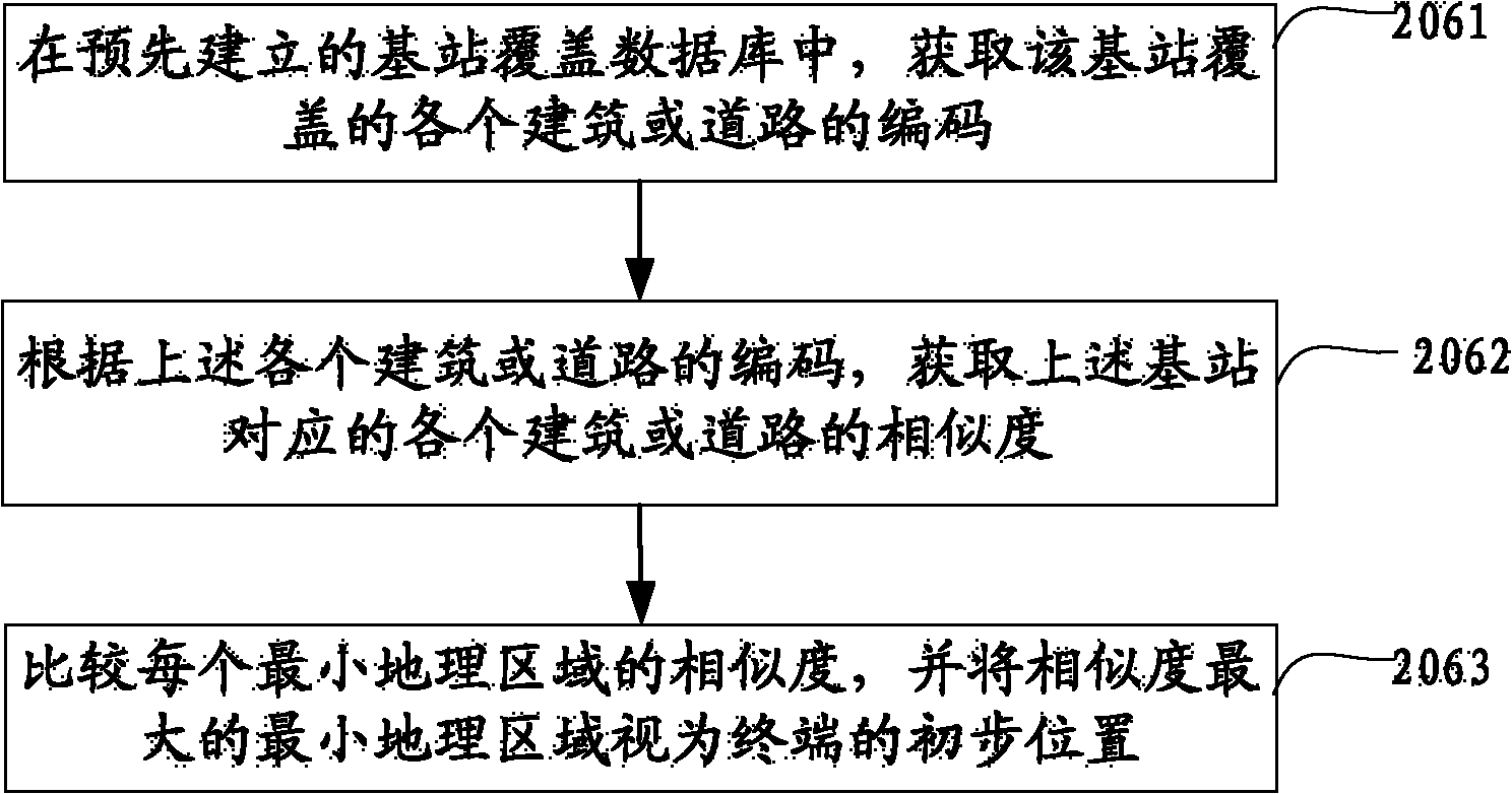
[0055] Step 102: According to the base station and the preset base station coverage database and characteristic parameter database, obtain the similarity of each minimum geographic area covered by the base station, and lock the preliminary position of the terminal to the minimum geographic area according to the similarity of each minimum geographic area Area, the smallest geographic area being specifically a building or a road;

[0056] Step 103: According to the minimum geographical area and the preset grid feature database, locate the position of the terminal to the grid.

[0057] The method provided...

Embodiment 2

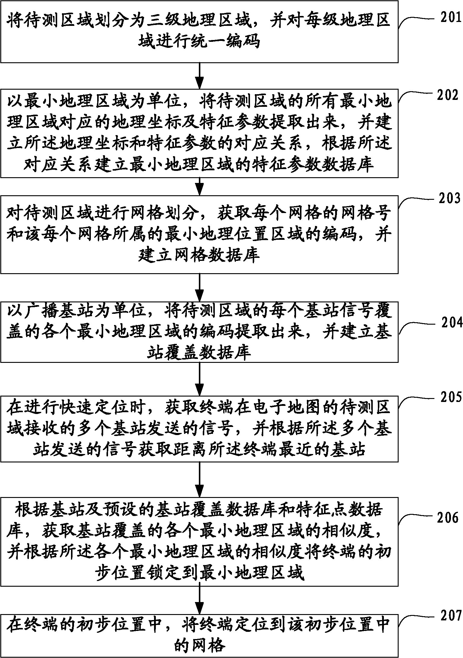
[0059] see figure 2 , the embodiment of the present invention provides a fast positioning method, which specifically includes:

[0060] Step 201: Divide the area to be tested into three levels of geographic areas, and uniformly code each level of geographic areas;

[0061] Specifically, in this embodiment, geographical location is mainly used as the basis for division, and the area to be measured is divided and coded step by step according to geography. A total of three levels of coding are performed, so as to obtain the codes of all the smallest geographical areas in the area to be tested. Here The smallest geographic area is a third-level geographic area, such as a building or a road.

[0062] For the first-level division, in order to simplify the division workload and unify the standard, this embodiment uses the existing postal code as the first-level code. For example, each group of postal codes in my country is composed of six Arabic numerals. The first and second digi...

Embodiment 3

[0115] see Figure 5 , the present embodiment provides a quick positioning device, the device includes:

[0116] An acquisition module 301, configured to acquire signals sent by a plurality of base stations received by the terminal in the area to be tested on the electronic map, and acquire the nearest base station to the terminal according to the signals sent by the plurality of base stations;

[0117] The preliminary positioning module 302 is configured to obtain the similarity of each minimum geographical area covered by the base station according to the base station and the preset base station coverage database and characteristic parameter database, and calculate the preliminary position of the terminal according to the similarity of each minimum geographical area Locked to a minimum geographic area, specifically a building or a road;

[0118] The positioning module 303 is configured to locate the position of the terminal to a grid according to the minimum geographic area...


PUM


Abstract

The invention discloses a quick positioning method and device, which belong to the field of navigation. The method comprises the following steps of: acquiring signals, which are transmitted by a plurality of base stations, received by a terminal at an area to be measured of an electronic map, and acquiring the base station which is nearest to the terminal according to the signals transmitted by the base stations; acquiring the similarity of all minimum geographic areas covered by the nearest base station according to the nearest base station and preset base station coverage database and characteristic parameter database, and locking the primary position of the terminal to the minimum geographic area according to the similarity of all the minimum geographic areas, wherein the minimum geographic area is specifically a building or a road; and positioning the position of the terminal to a grid according to the minimum geographic areas and a preset grid characteristic database. In the invention, the positioning is performed by taking the base station as a starting point, so that the positioning range is quickly reduced; and the positioning is performed by using a grid concept after the area is primarily positioned, so that the positioning efficiency is increased.

Description

technical field [0001] The invention relates to the field of navigation, in particular to a device for a fast positioning method. Background technique [0002] Geographical location information is important information that is closely related to people's lives. With the acceleration of the pace of modern life, geographical location information is playing an increasingly important role. The electronic map is a map that stores geographic location information in vector images, and can display latitude and longitude, altitude, heading, etc. The scale can be enlarged or reduced without affecting the display effect. People can locate their exact location according to the electronic map. [0003] Traditional positioning usually uses the handheld terminal to receive the positioning information, and directly calculates the position information through the built-in calculation module. This positioning method has a small amount of data, but the positioning accuracy is low, and it is ea...

Claims


Application Information

Patent Timeline
IPC IPC(8): H04W64/00
Inventor 邓中亮徐连明来奇峰余彦培袁协那日苏邓耀宇刘雯施浒立吕子平关维国李合敏
Owner BEIJING UNIV OF POSTS & TELECOMM
Why Eureka
Try Eureka