Three dimensional (3D) modeling and visualizing method of prehistoric settlement sites

A technology of 3D modeling and ruins, applied in the intersection of archaeology and 3D information visualization technology, can solve problems such as destruction, extinction, and information loss

Inactive Publication Date: 2011-10-12
NANJING UNIV OF INFORMATION SCI & TECH
View PDF2 Cites 14 Cited by
  • Summary
  • Abstract
  • Description
  • Claims
  • Application Information

AI Technical Summary

Problems solved by technology

[0002] Prehistoric settlement sites contain rich historical and cultural information and high archaeological value. They are important historical and cultural heritages in my country. Coupled with the destruction of human factors, it is facing the dilemma of gradually dying out as time goes by
In addition, a lot of important information in archaeological sites will be lost due to further archaeological excavations in the later period

Method used


Image

  • Three dimensional (3D) modeling and visualizing method of prehistoric settlement sites
  • Three dimensional (3D) modeling and visualizing method of prehistoric settlement sites
  • Three dimensional (3D) modeling and visualizing method of prehistoric settlement sites

Examples


Embodiment Construction

[0039] In order to make the purpose, technical solutions and advantages of the present invention clearer, the implementation of the present invention will be further described in detail below in conjunction with the accompanying drawings:

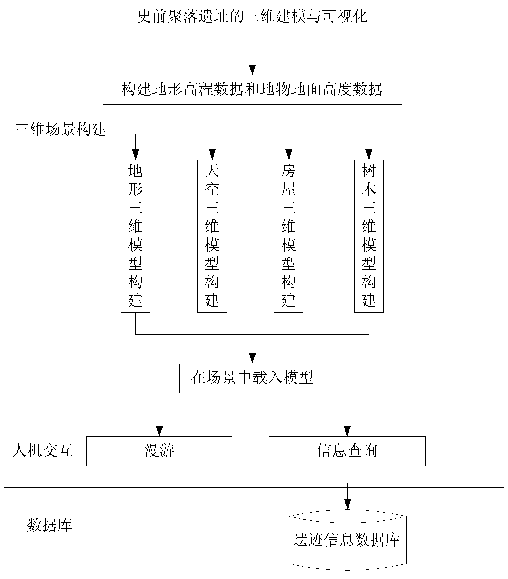
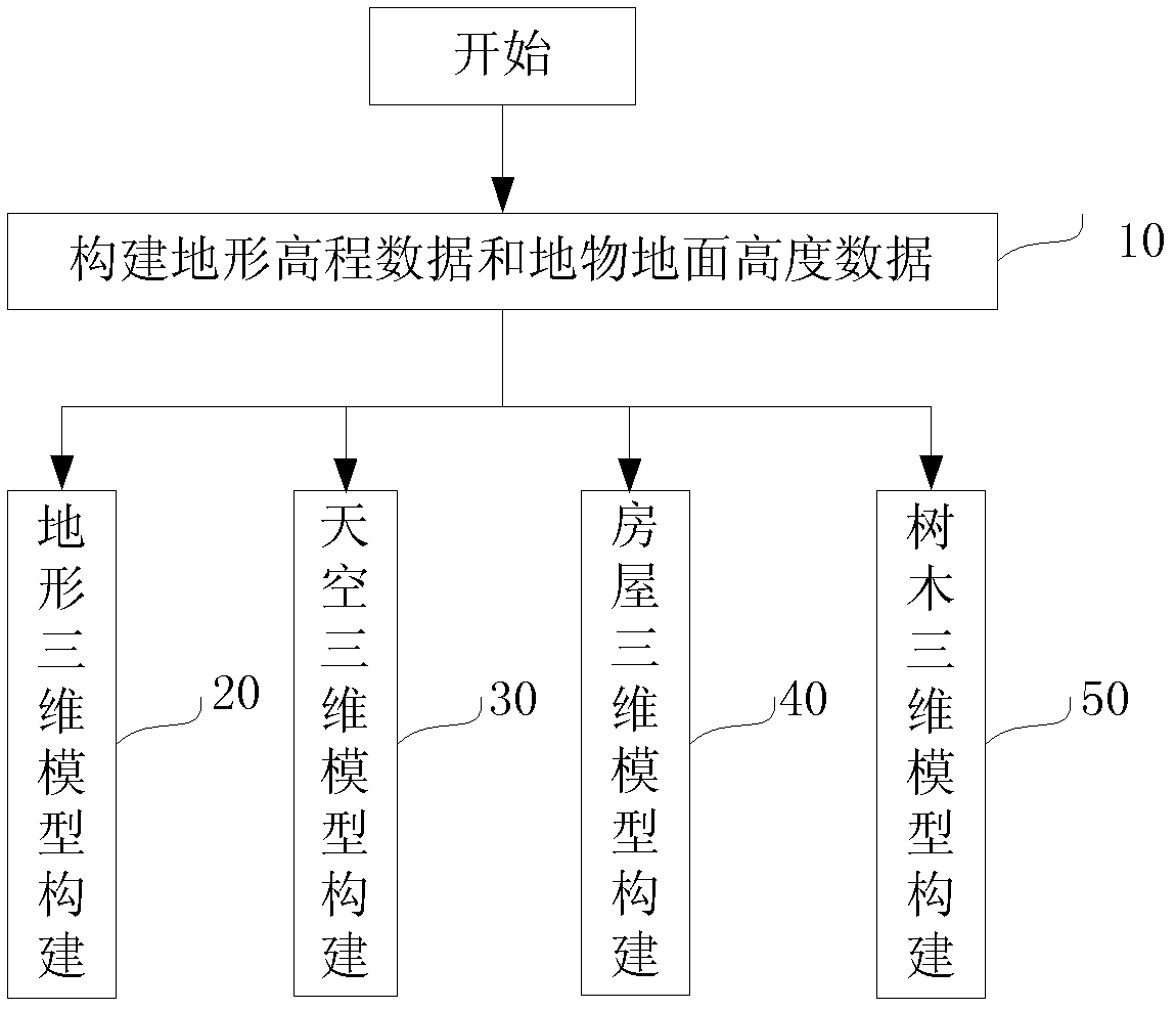
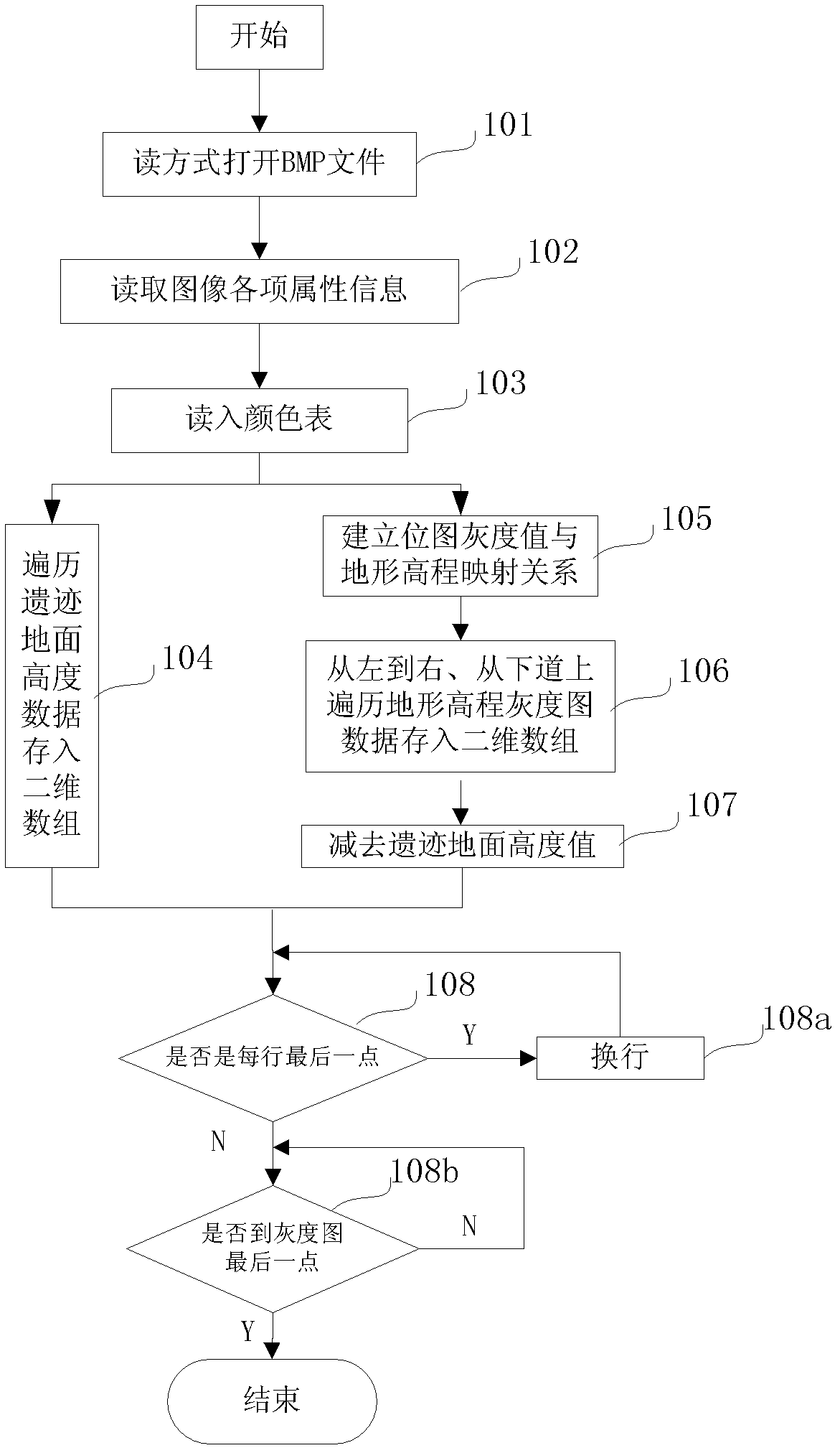
[0040] This example provides a 3D modeling and visualization method for prehistoric settlement sites, combined with image processing methods, extracts the uniform grid ground elevation data of real settlement sites, constructs a site information database, and uses different graphics elements and mathematical description methods Construct the same 3D model as in the ruins, and load the built 3D model of the ruins according to the real position in the ruins. Human-computer interaction functions such as roaming and information query are added to the 3D scene, and prehistoric settlement sites are restored with realistic and vivid images. The invention integrates technologies such as image processing, 3D digital modeling and geographic informati...


PUM


Abstract

The invention discloses a three dimensional (3D) modeling and visualizing method of prehistoric settlement sites, comprising the following steps of: (1) acquiring settlement site terrain data from pictures representing settlement site terrain altitude data and vestige information through an image processing method and digital elevation models; (2) establishing vivid settlement site virtual scenes according to truthful data; and (3) performing a human-computer interaction function in the settlement sites 3D scenes. According to the method in the invention, the image processing technology and the 3D visualizing technology are comprehensively utilized; based on settlement site archaeological data, the prehistoric settlement site virtual scenes are established for providing conditions for researching and developing the settlement sites; and a novel method for digitizing archaeological information is provided.

Description

technical field [0001] The present invention belongs to the intersecting field of archeology and three-dimensional information visualization technology. It mainly uses virtual reality technology to accurately digitally restore archaeological achievements, store archaeological information, and display archaeological achievements with vivid images and rigorous scientific connotations. Background technique [0002] Prehistoric settlement sites contain rich historical and cultural information and high archaeological value. They are important historical and cultural heritages in my country. Coupled with the destruction of human factors, it is facing the dilemma of gradually dying out as time goes by. In addition, a lot of important information in archaeological sites will be lost due to further archaeological excavations in the later period. The application of 3D visualization technology in archaeology can not only solve these problems, participants with different needs can inter...

Claims


Application Information

Patent Timeline
IPC IPC(8): G06T17/00
Inventor 毕硕本何晓庆潘秋羽陆良虎梁静涛
Owner NANJING UNIV OF INFORMATION SCI & TECH
Why Eureka
Try Eureka