
Electric distribution network geographic information obtaining method based on Google Earth remote sensing image

A remote sensing image and acquisition method technology, applied in electrical digital data processing, data processing applications, special data processing applications, etc., can solve the problem of increasing the cost of power distribution information management systems, the high price of large-scale maps, and the lack of clear and intuitive representation. and other problems, to achieve the effect of easy application and update maintenance, low cost, and conducive to daily scheduling and maintenance

Inactive Publication Date: 2011-10-19
DONGFANG ELECTRONICS
View PDF2 Cites 7 Cited by
  • Summary
  • Abstract
  • Description
  • Claims
  • Application Information

AI Technical Summary

Problems solved by technology

The current power distribution information management system generally uses the traditional vector electronic map as the background image, which is not clear and intuitive in terms of expression, and is expensive. Large-scale maps are more expensive, which greatly increases the cost of the power distribution information management system.

Method used


Image

  • Electric distribution network geographic information obtaining method based on Google Earth remote sensing image
  • Electric distribution network geographic information obtaining method based on Google Earth remote sensing image
  • Electric distribution network geographic information obtaining method based on Google Earth remote sensing image

Examples


Embodiment Construction

[0020] The present invention will be further described below in conjunction with the accompanying drawings and specific embodiments.

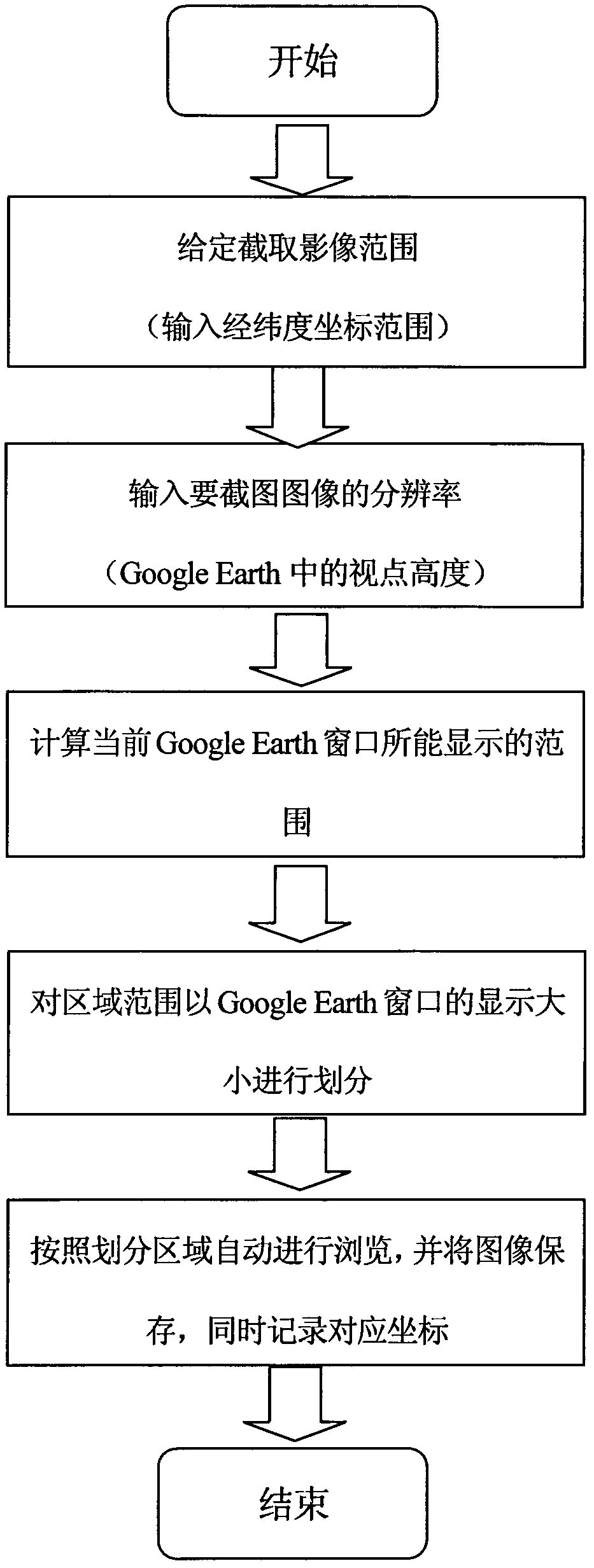
[0021] Such as figure 1 , Acquisition of remote sensing images: First, the latitude and longitude coordinate range of an area is given, and then the resolution of an image is given, which corresponds to the height of the viewpoint in Google Earth. Then use the API interface provided by Google Earth to adjust Google Earth to the corresponding viewpoint height, and at the same time adjust the viewing angle of Google Earth to zero. Then calculate the size of the geographical range that the current Google Earth window can display, and then divide the area range according to the display range of the current Google Earth window, and calculate the exact coordinates of the center points of all display windows; (this step should be noted, because the Google Earth window is below There is a Google icon, so that the icon does not appear on the image capt...


PUM


Abstract

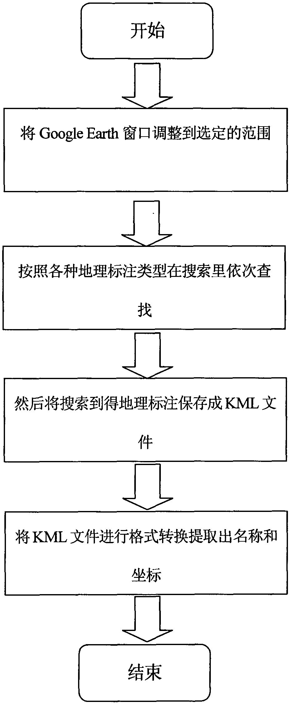
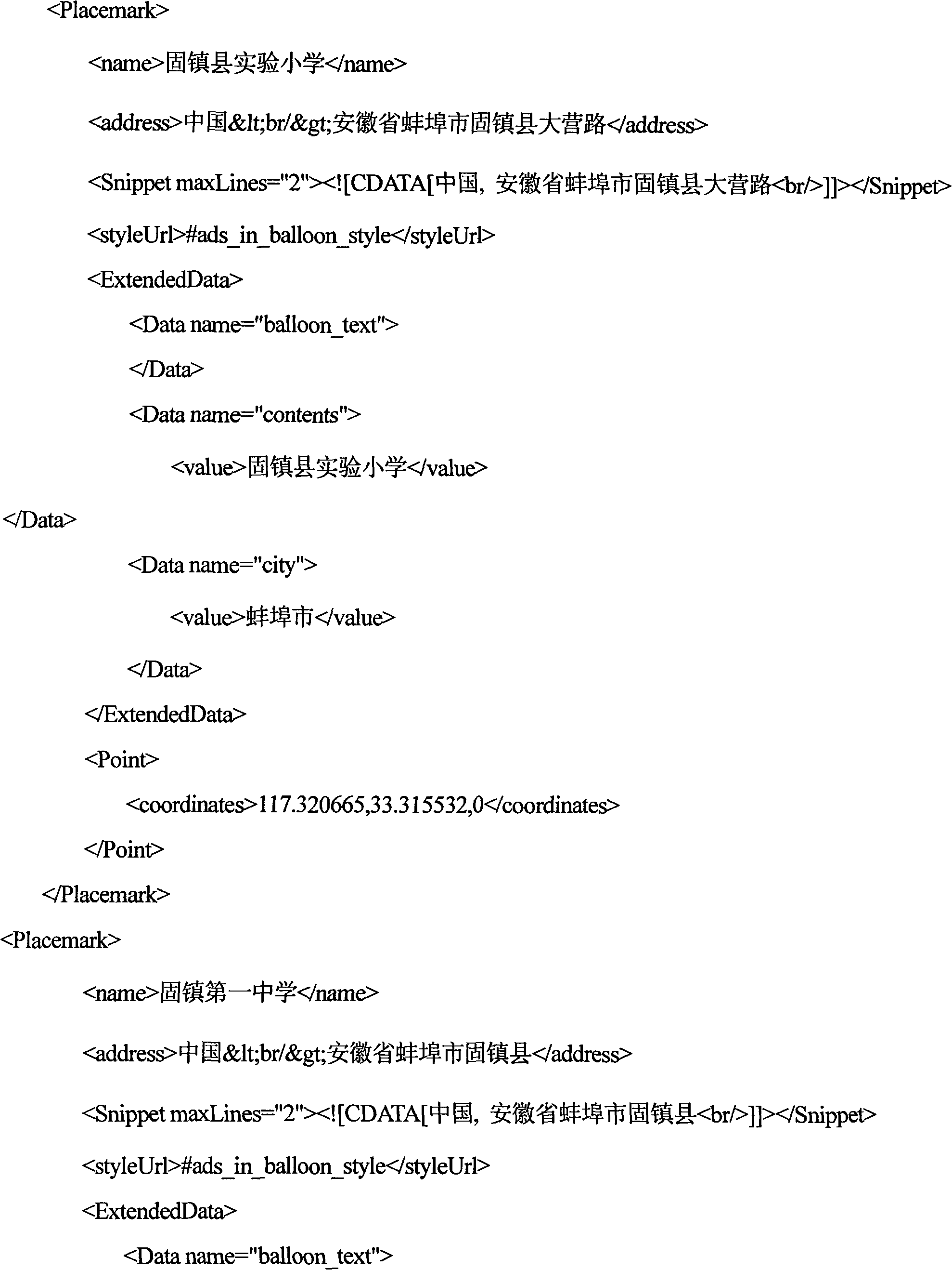
The invention discloses an electric distribution network geographic information obtaining method based on a Google Earth remote sensing image, comprising a Google Earth remote sensing image obtaining part and a geographic labeling obtaining part. A remote sensing image automatic screenshot with arbitrary resolution ratio can be realized through Google Earth, geographic coordinates of the image can be automatically obtained, coordinate conversion is carried out and is displayed on an electric network geographic information obtaining system; various types of KML (keyhole markup language) files labeled geographically are obtained through the Google Earth, and format conversion is carried out and is displayed on the electric network geographic information obtaining system. By adopting the method, intuitive and clear geographic background based on the Google Earth remote sensing image can be provided for the electric network management, so as to provide powerful technical support for services of an electric distribution network, such as maintenance, scheduling, operation and overhauling and the like.

Description

technical field [0001] The invention relates to an automatic acquisition method for an image map background of a distribution network geographic information system based on Google Earth remote sensing images, including methods for acquiring Google Earth remote sensing images and geographic labeling information. The method is mainly used in the field of power system automation. Background technique [0002] With the development of smart grid, communication technology, and computer technology, the power system is developing towards a high degree of informationization, automation and digitalization, and the scale of the power grid is expanding day by day. The power equipment and facility data, user data, and planning data that need to be managed are also increasing. Scientific decision-making depends to some extent on the amount of information that decision makers have. Power generation, transformation, and transmission systems are complex systems that contain a large amount of...

Claims


Application Information

Patent Timeline
Patent Type & Authority Applications(China)
IPC IPC(8): G06Q50/00G06F17/30
Inventor 景奉广王传起杨本志高贞彦衣振涛邹全喜甘家峰靳力谭凯宋新航
Owner DONGFANG ELECTRONICS
Learn More