Method for acquiring specific reference Gaussian plane rectangular coordinate based on continuous operational reference system (CORS) in real time

A real-time acquisition, space rectangular coordinate technology, applied in electrical components, wireless communication, etc., can solve the problems of leakage, increased use cost, and inability to be widely applied and promoted.

Active Publication Date: 2011-10-19
CHONGQING GEOMATICS & REMOTE SENSING CENT
View PDF2 Cites 13 Cited by
  • Summary
  • Abstract
  • Description
  • Claims
  • Application Information

AI Technical Summary

Problems solved by technology

[0004] 1. The secrecy of the coordinate conversion parameters is partially realized, but the secrecy of the coordinate datum is not realized, such as the coordinate value of the origin, the central meridian, etc.
[0005] 2. Tianbao and Lycra use the RTCM31 protocol to dynamically release coordinate conversion parameters to the outside world. Relevant units can obtain relevant information by analyzing the RTCM31 protocol. There is a possibility of leaking secrets. At the same time, users need to upgrade related equipment, which increases the cost of use for users
[0006] None of the existing technical solutions can achieve real-time acquisition of the Gaussian plane Cartesian coordinates of a specific benchmark while meeting the relevant requirements, so it cannot be widely applied and promoted

Method used


Image

  • Method for acquiring specific reference Gaussian plane rectangular coordinate based on continuous operational reference system (CORS) in real time
  • Method for acquiring specific reference Gaussian plane rectangular coordinate based on continuous operational reference system (CORS) in real time
  • Method for acquiring specific reference Gaussian plane rectangular coordinate based on continuous operational reference system (CORS) in real time

Examples


Embodiment Construction

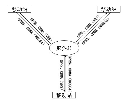
[0062] The invention is further illustrated by a non-limiting individual example. Such as figure 2 , when the traditional CORS system performs coordinate measurement, the mobile station uses GPRS (or CDMA) communication technology to send the approximate position NMEA (WGS84 datum) to the server. The server will generate a VRS correction information near NMEA, and then use GPRS (or CDMA) communication technology to send it to the mobile station for differential calculation. The mobile station can directly obtain the coordinates of the WGS84 datum. If you need to obtain the Gaussian plane rectangular coordinates of a specific datum, you must set the corresponding coordinate datum and conversion parameters on the handbook of the mobile station.

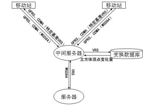
[0063] In order to avoid public release of real coordinate parameters, in figure 2 Made minor changes on the basis of the CORS system server and the mobile station, an intermediate server is added to communicate with the server and ...


PUM


Abstract

The invention provides a method for acquiring coordinates based on a continuous operational reference system (CORS) in real time, and relates to a method for acquiring a specific reference Gaussian plane rectangular coordinate based on the CORS by using general packet radio service (GPRS) (or code division multiple access (CDMA)) communication technologies in real time. According to the invention, a middle server is arranged between a mobile station and a server for bi-directionally communicating with the mobile station and the server respectively, decoding virtual reference station (VRS) difference information which is generated by the server, and appropriately changing the coordinates (X, Y, Z) so that a user of the mobile station cannot acquire the real world geodetic system (WGS) 84 coordinate; corresponding false parameters are set on a holding book of the mobile station so as to acquire the specific reference Gaussian plane rectangular coordinate and avoid real parameters issuing. By the system, software, hardware and use habit of the user are not changed; the specific reference Gaussian plane rectangular coordinate is acquired; and elevation of the measured position is directly acquired by using ground level precise models, so that the working efficiency of the user is greatly improved; and the method is widely applied in fields such as surveying and mapping controlling, precise navigating and the like.

Description

technical field [0001] The invention relates to a method for obtaining Gaussian plane rectangular coordinates of a specific reference in real time based on a CORS system by using GPRS or CDMA communication technology. The specific benchmarks include national54, 80 or local benchmarks, etc. Background technique [0002] Due to the development of network RTK technology, the accuracy and efficiency of coordinate acquisition have been improved, and the construction of CORS system has been intensified in various places. The CORS system can directly obtain the coordinates of the WGS84 datum, but in actual surveying and mapping applications, it is often necessary to obtain coordinates under a specific datum. In order to obtain the Cartesian coordinates of the Gaussian plane of a specific datum, the usual method is to set the necessary parameters (such as origin coordinates, central meridian, seven parameters, etc.) on the mobile station handbook, but these parameters cannot be mad...

Claims


Application Information

Patent Timeline
Patent Type & Authority Applications(China)
IPC IPC(8): H04W64/00
Inventor 罗灵军张泽烈袁超高翔夏定辉程宇翔张黎蒲德祥
Owner CHONGQING GEOMATICS & REMOTE SENSING CENT
Why Eureka
Try Eureka