Bayesian path planning device and method based on GPS detection

A path planning and Bayesian classifier technology, applied to road network navigators and other directions, can solve the problems of incorporating prior inference methods and the inability to avoid the randomness of real-time traffic information, and achieve good practicability and flexible integration effects

Inactive Publication Date: 2011-12-14
CHINA UNIV OF PETROLEUM (EAST CHINA)
View PDF6 Cites 23 Cited by
  • Summary
  • Abstract
  • Description
  • Claims
  • Application Information

AI Technical Summary

Problems solved by technology

The method of assigning empirical information to road weights for path planning, in the case of real-time traffic information, has the same problem as the traditional optimal path method, and it cannot avoid the randomness of real-time traffic information
[0006] From the perspective of the existing path planning technical methods

Method used


Image

  • Bayesian path planning device and method based on GPS detection
  • Bayesian path planning device and method based on GPS detection
  • Bayesian path planning device and method based on GPS detection

Examples


Embodiment Construction

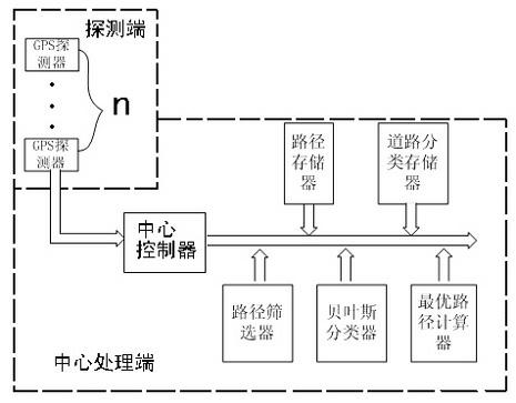
[0034] The specific implementation of this device is as follows:

[0035] Implementation on the probing side:

[0036] Use GPS detectors to obtain travel experience data. Select n drivers who are very familiar with the regional road network that needs to be analyzed, install GPS detectors on the cars of these n drivers, and use GPS to record their daily travel data, including

[0037] Including the starting point and the ending point of its travel route. After cumulatively recording their travel paths for a period of time (such as one month), according to the GPS detectors and records on the vehicles of these drivers who are familiar with real-time roads, the travel GPS trajectory data of n experienced drivers can be obtained.

[0038] Implementation steps of the central processing terminal:

[0039] The data transmission among the modules of the whole central processing terminal is controlled by the central controller, and the operation steps are also controlled by the...


PUM


Abstract

The invention relates to a Bayes path planning device and method based on GPS (Global Positioning System) detection. The method provided by the invention is a priori path finding method for simulating a driver by adopting a method for evaluating priori information by utilizing priori knowledge. The device provided by the invention contains a priori deduction method of the driver into the path planning device by utilizing a Bayes classifier, and the device is the path planning method formed after the patter recognition processing is carried out on a road network based on the classifier. In theinvention, the Bayes classifier is constructed to form the prior recognition of the road network by utilizing the priori deduction of the driver on real-time traffic conditions of the road network; the path planning device and method formed based on prior recognition can respectively give different optimal paths according to the priori knowledge in rush hours and in non-rush hours at different traffic time intervals. The device and method provided by the invention have good practicality and can be flexibly integrated into various navigation systems based on road traffic.

Description

Technical field: [0001] The invention relates to a path planning device and method suitable for use based on a priori inference in actual traffic conditions, in particular to a GPS detection-based Bayesian path planning device and method. Background technique: [0002] At present, the Global Positioning System (GPS) has been widely used as a positioning and navigation device on various vehicles, such as vehicle navigation systems, vehicle positioning monitoring systems, floating vehicle systems in transportation departments, and so on. On the other hand, the optimal path obtained by the path optimization methods in our various navigation systems is often the shortest path in terms of absolute time or length measurement in actual use. However, due to the random nature of the real-time traffic conditions of the road, such an optimal path in the metric sense is often not so consistent with the driver's prior knowledge, and such an optimal path is often not the optimal path ...

Claims


Application Information

Patent Timeline
IPC IPC(8): G01C21/34
Inventor 曾喆李清泉万剑华
Owner CHINA UNIV OF PETROLEUM (EAST CHINA)
Why Eureka
Try Eureka