An Error Correction Method in GNSS Network Differential Positioning System

A positioning system and error correction technology, used in satellite radio beacon positioning systems, radio wave measurement systems, measurement devices, etc., can solve the problems of inability to meet precise positioning and low positioning accuracy.

Inactive Publication Date: 2011-12-28
SOUTHEAST UNIV
View PDF3 Cites 74 Cited by
  • Summary
  • Abstract
  • Description
  • Claims
  • Application Information

AI Technical Summary

Problems solved by technology

However, for areas with relatively large elevation differences, the traditional tropospheric error estimation model ignores the influence of elevation fac

Method used


Image

  • An Error Correction Method in GNSS Network Differential Positioning System
  • An Error Correction Method in GNSS Network Differential Positioning System
  • An Error Correction Method in GNSS Network Differential Positioning System

Examples


Embodiment Construction

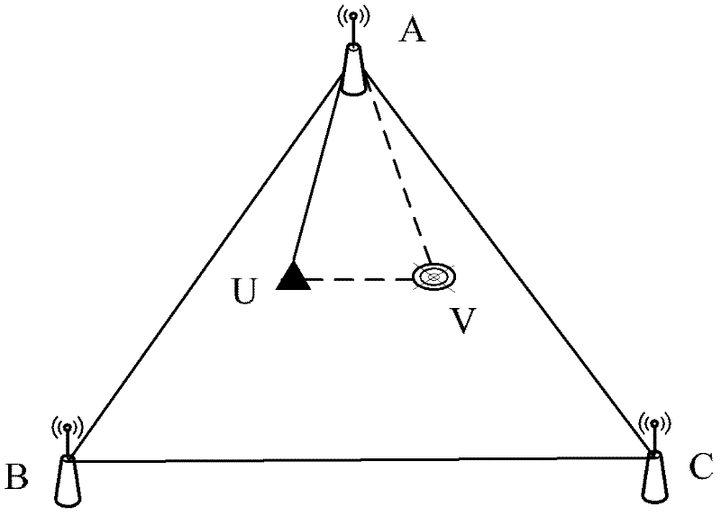
[0063] see figure 1 , for the network RTK triangulation network of three reference stations, A, B, and C are reference stations, where A is the main reference station, B and C are auxiliary reference stations, and u is the mobile station.

[0064] 1) Calculate the three-dimensional position vectors of the positions of each reference station and mobile station.

[0065] The three-dimensional position vector calculation method of the reference station and mobile station position: take the WGS-84 geodetic coordinates as the central meridian of the reference station as the central meridian to perform Gaussian projection to obtain the WGS-84 plane coordinates, and then convert the WGS-84 plane coordinates through 7 parameters or 4 The local plane coordinates are obtained through parameter conversion, then the plane coordinates and elevation values ​​x, y, and h of each site can be obtained.

[0066] 2) In the triangular reference station network shape of the CORS network, construc...


PUM


Abstract

In a virtual reference station, systematic biases existing in troposphere error corrections can be caused by elevation biases between a mobile station and reference stations, thus, the troposphere correction precision is reduced, and the positioning effect of the mobile station is influenced. The invention discloses an error correction method in a global navigation satellite system (GNSS) network differential positioning system. When comprehensive error corrections between the mobile station and the reference stations are obtained through an interpolation computation model, under the condition of considering the influences of elevations, a three-dimensional linear combination interpolation method is adopted to improve the accuracy and the reliability of network real time kinematic (RTK) differential correction information, and the real-time effective differential correction information of the mobile station is interpolated by utilizing spatially-correlated errors resolved by the reference station, including an ionosphere error and a troposphere error, according to the spatial and positional relations between the mobile station and the surrounding reference stations. By adopting the method, the troposphere correction precision can be increased to centimeter level from decimeter level in interpolation computation corrections, and the network RTK positioning accuracy is improved.

Description

technical field [0001] The invention relates to the determination of inter-station network error correction numbers of a continuous operation reference station (CORS) system, in particular to an error correction method in a GNSS network differential positioning system. It belongs to the field of GNSS network differential positioning. Background technique [0002] GNSS network differential positioning technology is currently a popular technology in the field of satellite positioning. It is widely used in surveying and mapping, land and resources investigation and other industries. The positioning system generates virtual observation values ​​at VRS (Virtual Reference Station) through interpolation calculation methods based on the position of the mobile station. , the mobile station receives the network differential information and VRS to form a short baseline, and performs differential calculation through the conventional RTK (real-time carrier phase difference technology) ca...

Claims


Application Information

Patent Timeline
IPC IPC(8): G01S19/41
Inventor 潘树国王庆沈雪峰汪登辉
Owner SOUTHEAST UNIV
Why Eureka
Try Eureka