Annotation method based on monolithic InSAR (interferometric synthetic aperture radar) orthophoto

An orthophoto, single-chip technology, applied in the field of airborne synthetic aperture radar interferometry, can solve problems such as the inability to meet the needs of single-chip InSAR image adjustment, the poor effect of single-chip InSAR image adjustment, and the inability to fully utilize InSAR technology.

Inactive Publication Date: 2012-01-11
AERIAL PHOTOGRAMMETRY & REMOTE SENSING CO LTD +1
View PDF3 Cites 5 Cited by
  • Summary
  • Abstract
  • Description
  • Claims
  • Application Information

AI Technical Summary

Problems solved by technology

[0011] The technical problem to be solved by the present invention is to provide a method of mapping based on a single InSAR orthophoto, which is reasonable in design, simple in method steps, convenient to implement, good in use, and accurate in mapping. High, can effectively solve the problems that the existing all-digital aerial photogrammetry system and mapping method cannot meet the needs of single-chip InSAR image mapping, the effect of single-chip InSAR image mapping is poor, and the advantages of InSAR technology cannot be fully utilized.

Method used


Image

  • Annotation method based on monolithic InSAR (interferometric synthetic aperture radar) orthophoto
  • Annotation method based on monolithic InSAR (interferometric synthetic aperture radar) orthophoto
  • Annotation method based on monolithic InSAR (interferometric synthetic aperture radar) orthophoto

Examples


Embodiment Construction

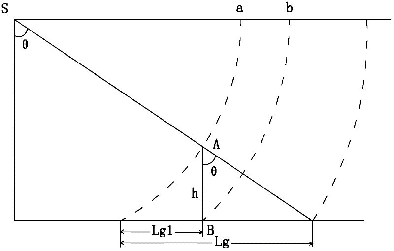
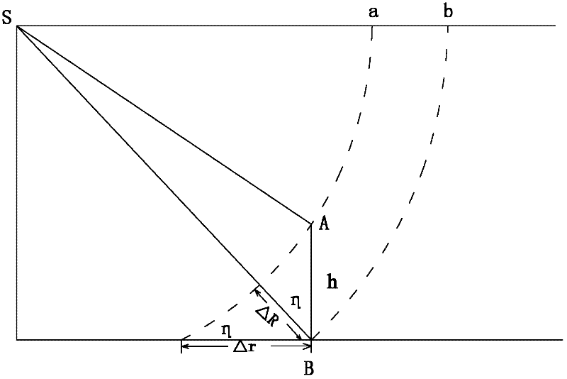
[0063] like figure 1 , figure 2 , image 3 and Figure 4 As shown, the method of surveying and mapping based on a single InSAR orthophoto image of the present invention comprises the following steps:

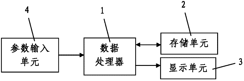
[0064] Step 1. Acquisition of single-slice InSAR orthophoto images: Using the airborne InSAR system and the conventional airborne synthetic aperture radar interferometry method, multiple single-slice InSAR images of the survey area are obtained, and the obtained multiple single-slice InSAR images are obtained. All the slices of InSAR images are stored in the storage unit 2 connected to the data processor 1; the multiple single slices of InSAR images are all orthophotos.

[0065] Step 2. Carry out mapping based on the single-slice InSAR orthophoto image: perform mapping on the multiple single-slice InSAR images stored in the storage unit 2 in step 1, and adjust the multiple single-slice InSAR images. The drawing methods are the same; for any single InSAR image, the drawing m...


PUM


Abstract

The invention discloses an annotation method based on a monolithic InSAR orthophoto. The method comprises the following steps: 1, acquiring the monolithic InSAR orthophoto; 2, annotating based on the monolithic InSAR orthophoto according to the following annotation processes: 201, establishing a ground object characteristic database of the InSAR orthophoto, 202, carrying out indoor interpretation: determining and positioning ground objects according to the ground object characteristic database of the InSAR orthophoto, 203, carrying out outdoor check, 204, carrying out annotation and supplement measure on a shadow region and a layover region, 205, carrying out annotation and supplement measure on new added ground objects and concealed ground objects, and 206, carrying out indoor data processing; and 3, carrying out junction processing. The annotation method which has the advantages of reasonable design, simple step, convenient realization, good usage effect, and high annotation precision allows practical problems that present fully digital aerophotogrammetry systems and annotation methods cannot satisfy annotation needs of the InSAR orthophoto, the annotation effect of the monolithic InSAR orthophoto is bad, technical advantages of an InSAR cannot fully performed and the like to be solved.

Description

technical field [0001] The invention belongs to the technical field of airborne synthetic aperture radar interferometry, and in particular relates to a mapping method based on a single InSAR orthophoto image. Background technique [0002] InSAR (Interferometric Synthetic Aperture Radar; abbreviation: Interferometric Synthetic Aperture Radar or Synthetic Aperture Radar Interferometry) technology originated in the United States, and has been continuously improved and matured in developed countries in Europe and the United States, and its application fields have also been continuously promoted. For countries with developed InSAR technology, such as the United States and German space information industry technology companies, the practical airborne high-resolution InSAR technology has been used as a new and advanced technical means for terrain surveying, forest surveying, Resource investigation and environmental mapping, geological environment and disaster monitoring, etc., and ...

Claims


Application Information

Patent Timeline
Patent Type & Authority Applications(China)
IPC IPC(8): G01C11/00G01S13/90
Inventor 苗小利谭克龙谢志清彭桂辉刘敏刘海军梁涛宋健马进
Owner AERIAL PHOTOGRAMMETRY & REMOTE SENSING CO LTD
Why Eureka
Try Eureka