Classification-based high time definition and high space definition remote sensing data quantitative fusing method

A technology with high temporal resolution and high spatial resolution, applied in image data processing, instruments, calculations, etc., can solve the problems of not considering the inconsistency of changes within the pixel, and it is difficult to run the system.

Inactive Publication Date: 2014-03-26
INST OF GEOGRAPHICAL SCI & NATURAL RESOURCE RES CAS
View PDF3 Cites 0 Cited by
  • Summary
  • Abstract
  • Description
  • Claims
  • Application Information

AI Technical Summary

Problems solved by technology

[0005] The inadequacies of the above-mentioned quantitative remote sensing parameter fusion can be summarized as follows: (1) The assumption that the composition ratio based on pixel decomposition is constant within a certain time range is difficult to establish, because the evolution curves of different types of ground objects over time are different. (2) The assumption that the ratio of low spatial resolution data to high spatial resolution data is the same does not take into account the inconsistency of changes within the pixel; (3) All data with low spatial resolution and high temporal resolution are assumed to be quality Complete data, very few actual data meet this condition, it is difficult to use in the running system

Method used


Image

  • Classification-based high time definition and high space definition remote sensing data quantitative fusing method
  • Classification-based high time definition and high space definition remote sensing data quantitative fusing method
  • Classification-based high time definition and high space definition remote sensing data quantitative fusing method

Examples


Embodiment Construction

[0032] The present invention will be described in further detail below in conjunction with the accompanying drawings.

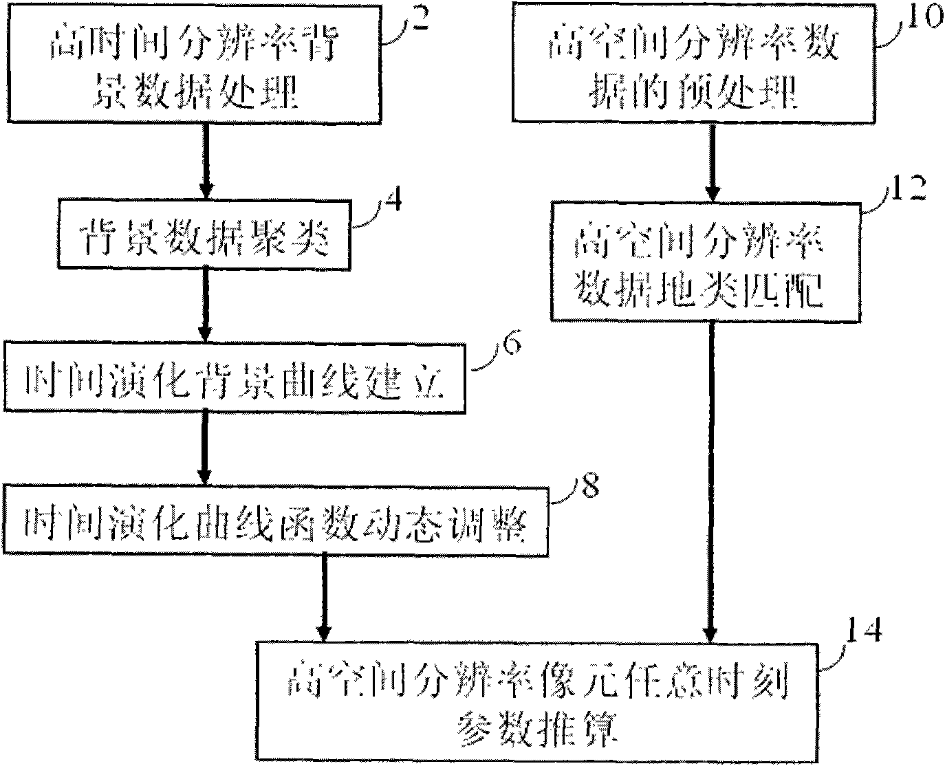
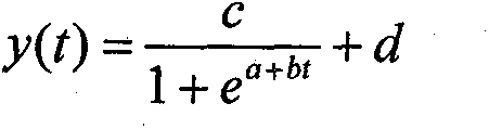
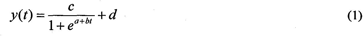
[0033] The flow chart of the quantitative fusion of high temporal resolution and high spatial resolution remote sensing data based on classification realized by the present invention is as follows: figure 1 shown. figure 1 Including high time resolution background data processing unit 2, background data clustering unit 4, time evolution background curve establishment unit 6, time evolution curve function dynamic adjustment unit 8, high spatial resolution data preprocessing unit 10, high spatial resolution data Terrain type matching unit 12, high spatial resolution pixel parameter estimation unit 14 at any time.

[0034] Unit 2 takes the average value of all non-snow clear-air parameters and reflectance data at the same location at the same time in different years as the background value of the time. If all values ​​are cloud, it is marked as cloud, and if al...


PUM


Abstract

The invention provides a high time definition and high space definition remote sensing data quantitative fusing method, which is characterized in that: high time definition data is used for establishing function curve of land surface parameter time evolution, and high space definition data is used for restricting the space distribution characteristics of the parameters so as to obtain the land surface parameter of high time definition and high space definition; and the method has the advantages that: by adopting the high time definition data, the completeness of the data is not required, so the treatment of the noise elimination is unnecessary to insert before the fusion; when the high time definition data is increased, the time evolution function can be gradually optimized, the time evolution relation of the parameters can be well described when the data is less so as to realize the data fusion; the precise space position matching is not required before the fusion of the two categories of data; and when one category of the data is missed, the historic background data can be used for substituting the missed data. The method can be used for monitoring the growth of crops, and also can be used for fusing multiple categories of data and for filling the missing of the acquired data (such as the incomplete data caused by the shielding of cloud).

Description

technical field [0001] The invention belongs to the field of remote sensing digital image processing and quantitative data fusion. The present invention is a method for realizing the quantitative fusion of remote sensing data with high temporal resolution and high spatial resolution based on classification, especially a function curve of time evolution of surface parameters established by using high temporal resolution data, and using high spatial resolution data A method of constraining the spatial distribution characteristics of parameters to obtain surface parameters with high temporal resolution and high spatial resolution. The invention can be used in fields such as crop growth monitoring, and can also be used for fusion of various types of data to fill in the absence of historical data. Background technique [0002] The development of modern remote sensing technology enables humans to obtain remote sensing data with different characteristics from different remote sens...

Claims


Application Information

Patent Timeline
Patent Type & Authority Patents(China)
IPC IPC(8): G06T5/50G06T5/00
Inventor 刘荣高刘洋
Owner INST OF GEOGRAPHICAL SCI & NATURAL RESOURCE RES CAS
Why Eureka
Try Eureka