Method and system for compensating atmospheric refraction in optical satellite remote sensing data geographic positioning

An optical satellite and remote sensing data technology, which is applied in the field of remote sensing image processing and can solve problems such as positioning error and remote sensing image deformation.

Inactive Publication Date: 2012-02-08
TSINGHUA UNIV
View PDF3 Cites 11 Cited by
  • Summary
  • Abstract
  • Description
  • Claims
  • Application Information

AI Technical Summary

Problems solved by technology

[0004] In the process of remote sensing imaging, due to various reasons, there is a cert

Method used


Image

  • Method and system for compensating atmospheric refraction in optical satellite remote sensing data geographic positioning
  • Method and system for compensating atmospheric refraction in optical satellite remote sensing data geographic positioning
  • Method and system for compensating atmospheric refraction in optical satellite remote sensing data geographic positioning

Examples


Embodiment Construction

[0026] The present invention will be described in detail below in conjunction with the accompanying drawings to further illustrate the purpose, scheme and effect of the present invention, but the accompanying drawings are not intended to limit the protection scope of the present invention.

[0027] The purpose of the invention is to compensate the error caused by atmospheric refraction in the geographical positioning of optical satellite remote sensing data, thereby improving the precision of geographical positioning.

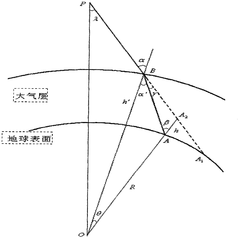
[0028] In order to describe the compensation method of the present invention more clearly, the process of geolocation of conventional optical satellite remote sensing data is introduced at first: the essence of performing remote sensing image geolocation is to establish a certain pixel coordinate (x, y) of remote sensing image and its corresponding ground point (Lon , Lat), where Lon and Lat are the longitude and latitude of the ground point respectively. In or...


PUM


Abstract

The invention discloses a method and a system for compensating atmospheric refraction in optical satellite remote sensing data geographic positioning. The method for compensating the atmospheric refraction in the optical satellite remote sensing data geographic positioning comprises an earth radius compensating step, and is used for calculating the coordinate of a ground point corresponding to a certain pixel point in a satellite image by supposing that the earth radius is equal to the summation of the actual earth radius and the compensation amount of the earth radius. The method not only can be used for performing correction on the remote sensing data of SPOT-5, but also can be used for performing correction on other satellite remote sensing data; and due to the adoption of the method, the positioning accuracy after the compensation of the atmospheric refraction is obviously improved.

Description

technical field [0001] The invention belongs to the technical field of remote sensing image processing, and relates to a geographic positioning method for optical remote sensing satellite data, in particular to a method for improving positioning accuracy through atmospheric refraction compensation in geographic positioning. Background technique [0002] With the continuous development of satellite earth observation technology in terms of spatial resolution, spectral resolution, time resolution and observation mode, the demand for comprehensive quantitative processing, value-added processing and in-depth application processing of satellite remote sensing data is increasing, especially in map In application processing such as surveying and mapping, fusion of multi-source satellite remote sensing data, and ground target monitoring, the problem of high-precision geometric positioning of satellite remote sensing data has become a bottleneck problem that needs to be solved urgently...

Claims


Application Information

Patent Timeline
IPC IPC(8): G01S17/89G01S17/06
Inventor 马洪兵孙卫东张霖
Owner TSINGHUA UNIV
Why Eureka
Try Eureka