GPS/SINS (global positioning system/strapdown inertial navigation system) combined navigating system with high anti-interference performance and realizing method thereof

An integrated navigation system, high anti-jamming technology, applied in the field of GPS/SINS integrated navigation system with high anti-jamming performance, can solve problems such as enhancing the robustness of jamming signals, avoid estimation links, avoid saturation and blocking, and enhance real-time sexual effect

Inactive Publication Date: 2012-02-15
BEIHANG UNIV
View PDF5 Cites 82 Cited by
  • Summary
  • Abstract
  • Description
  • Claims
  • Application Information

AI Technical Summary

Problems solved by technology

[0005] The purpose of the present invention is to solve the deficiencies of the existing GPS anti-jamming technology, providing a GPS / SINS integrated navigation system with high anti-jamming performance based on airspace adaptive zeroing antenna and its implementation method, which enhances the integrated navigation system Robustness in dealing with complex types of interfering signals

Method used


Image

  • GPS/SINS (global positioning system/strapdown inertial navigation system) combined navigating system with high anti-interference performance and realizing method thereof
  • GPS/SINS (global positioning system/strapdown inertial navigation system) combined navigating system with high anti-interference performance and realizing method thereof
  • GPS/SINS (global positioning system/strapdown inertial navigation system) combined navigating system with high anti-interference performance and realizing method thereof

Examples


Embodiment Construction

[0037] The present invention will be described in detail below in conjunction with the accompanying drawings.

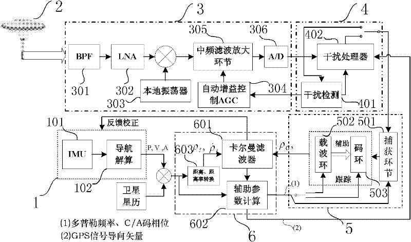
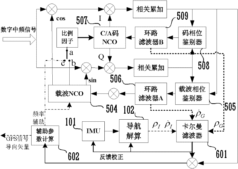
[0038] A kind of high anti-interference performance GPS / SINS integrated navigation system of the present invention, as figure 1 As shown, it includes a SINS module 1, a GPS array antenna 2, a radio frequency front end 3, an interference suppression module 4, a baseband processing unit 5 and an integrated navigation unit 6;

[0039] The SINS module 1 includes an inertial measurement unit (IMU) 101 and a navigation solution link 102 . The inertial measurement unit 101 has a gyroscope and an accelerometer, which are used to measure the angular rate and specific force of the carrier respectively, and the obtained specific force and angular rate information is transmitted to the navigation solution link 102, and the navigation solution link 102 is measured according to the IMU101 Calculate the position (P), velocity (V) and attitude (A) of the carrier based on the specif...


PUM


Abstract

The invention discloses a GPS/SINS (global positioning system/strapdown inertial navigation system) combined navigating system with high anti-interference performance and a realizing method thereof, which belong to the technical field of navigation. The system comprises a GPS array antenna, a radio-frequency front end, an interference inhibiting module, a GPS baseband processing link, an SINS module and a combined navigating unit. The method comprises the following steps: 1, receiving a GPS signal and treating the GPS signal by the radio-frequency front end; 2, detecting high-power electromagnetic interference; 3, regulating an antenna beam in a self-adaptive way and filtering to remove a high-power interference signal; 4, carrying out the navigation resolution and the information fusion of a GPS and an SINS; and 5, obtaining an auxiliary parameter. The system and the realizing method have favorable dynamic tracking capability and anti-interference performance; the high-power interference signal can be effectively prevented from causing the saturation and the jamming of a GSP radio-frequency front end; and the robustness performance of the navigating system for dealing with a complicated interference environment is improved.

Description

technical field [0001] The invention belongs to the technical field of navigation, and relates to a GPS / SINS integrated navigation system with high anti-interference performance and a realization method. Background technique [0002] The Global Positioning System (GPS) has the advantages of high precision, all-weather, and global coverage, and has been widely valued and applied in military and civilian navigation fields. However, GPS is a radio navigation system with poor dynamic performance and anti-interference ability. Especially for military applications, because the carrier is often in high-speed maneuvering and enemy electromagnetic interference environment, it is difficult for conventional GPS receivers to provide users with continuous , High-precision navigation and positioning information. The strapdown inertial navigation system (SINS) is a completely autonomous navigation system that can output the position, velocity and attitude of the carrier at a relatively hi...

Claims


Application Information

Patent Timeline
Patent Type & Authority Applications(China)
IPC IPC(8): G01S19/49G01S19/21
Inventor 王新龙纪新春
Owner BEIHANG UNIV
Why Eureka
Try Eureka