
Real-time monitoring and early-warning method for deformation of geotechnical engineering based on digital photogrammetry

A technology of geotechnical engineering and digital photography, which is applied in measuring devices, image data processing, instruments, etc., can solve the problems of inability to realize simultaneous analysis of image acquisition and image deformation, and achieve the effects of easy promotion, economical use, and good stability

Active Publication Date: 2012-06-20
CHINA UNIV OF MINING & TECH
View PDF3 Cites 56 Cited by
  • Summary
  • Abstract
  • Description
  • Claims
  • Application Information

AI Technical Summary

Problems solved by technology

[0003] The purpose of the present invention is to provide a real-time monitoring and early warning method for geotechnical engineering deformation based on digital photography, to solve the problem that the existing deformation monitoring technology based on digital photography cannot realize the simultaneous analysis of image acquisition and image deformation

Method used


Image

  • Real-time monitoring and early-warning method for deformation of geotechnical engineering based on digital photogrammetry
  • Real-time monitoring and early-warning method for deformation of geotechnical engineering based on digital photogrammetry
  • Real-time monitoring and early-warning method for deformation of geotechnical engineering based on digital photogrammetry

Examples


Embodiment 1

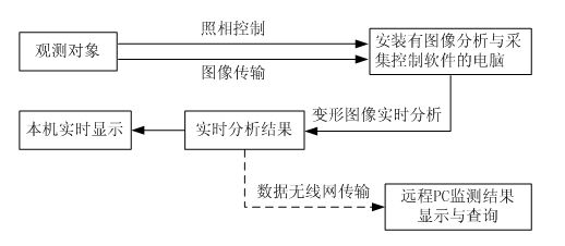
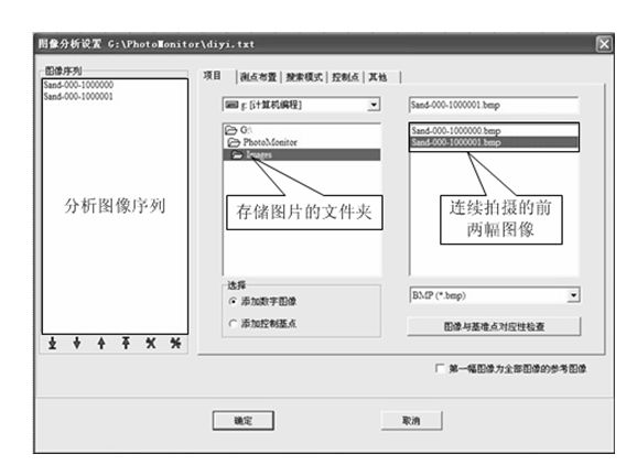
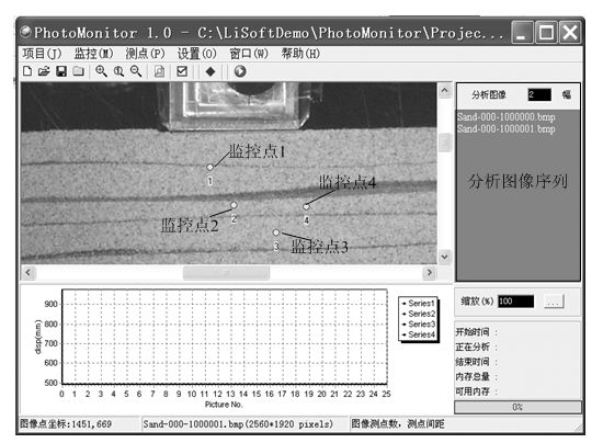
[0044] Embodiment 1: including the following steps: (a) using a high-definition digital camera and a lighting lamp matched with the high-definition digital camera as an image acquisition device for a geotechnical target, monitoring the surface of the geotechnical target; monitoring the geotechnical target in a laboratory When monitoring the surface of the geotechnical engineering target on a large engineering structure, set a "cross" artificial marker point on the surface of the geotechnical engineering target; (b) at a distance of about Set up a high-definition digital camera and lighting at a distance of 2 to 4m. The high-definition digital camera is connected to a computer at the monitoring site. The high-definition digital camera and lighting are aimed at the geotechnical engineering target. The relevant parameters of the high-definition digital camera are adjusted to make the image clear and continuous shooting Two images, and store the images in the preset folder connecte...


PUM


Abstract

A real-time monitoring and early-warning method for the deformation of geotechnical engineering based on digital photogrammetry is disclosed, wherein the method is performed by a group consisting of an image acquisition and transmission device, image real-time synchronization analysis software PhotoMonitor, and a wireless network transmission device. The real-time monitoring and early-warning method for the deformation of geotechnical engineering based on digital photogrammetry comprises the following steps: image acquisition for an observed target is performed by a high-definition digital camera, and an image is transmitted to a computer installed with PhotoMonitor via a data cable; the PhotoMonitor automatically detects the newly-acquired image, and then automatically names the image and adds the image in an analysis image sequence to calculate the real-time displacement and displacement speed of the observed target; after the calculation is finished, the PhotoMonitor displays the result on the screen of a local computer; simultaneously, the result data is transmitted via a wireless network and displayed on the screen of a remote computer, and an early-warning signal is sent if the result exceeds a preset control reference value. The real-time monitoring and early-warning method for the deformation of geotechnical engineering based on digital photogrammetry has the advantages of being simple and flexible, economic in use, high in accuracy and easy in popularization.

Description

technical field [0001] The invention relates to a method for real-time monitoring and early warning of geotechnical engineering deformation, in particular to a method for real-time monitoring and early warning of geotechnical engineering deformation based on digital photography. Background technique [0002] In the field of geotechnical engineering, including laboratories and engineering sites, especially during the construction of urban subways and important underground projects, in order to ensure the safety of engineering structures or surrounding important buildings and structures, the real-time monitoring of deformation is very important and emphasized, and the commonly used The real-time deformation monitoring system based on the total station is expensive and complicated to operate. At present, the widely used CCD-based remote video network monitoring system can only collect and replay conventional dynamic images, and cannot realize the synchronization of target image...

Claims


Application Information

Patent Timeline
Patent Type & Authority Applications(China)
IPC IPC(8): G01B11/16G06T7/00
Inventor 李元海靖洪文林志斌
Owner CHINA UNIV OF MINING & TECH
Learn More