Multi-level embedded integrated navigation system and navigation method

An integrated navigation system and integrated navigation technology, applied in the direction of integrated navigator, etc., can solve the problem of low attitude accuracy

Active Publication Date: 2012-06-27
NANJING UNIV OF AERONAUTICS & ASTRONAUTICS
View PDF5 Cites 25 Cited by
  • Summary
  • Abstract
  • Description
  • Claims
  • Application Information

AI Technical Summary

Problems solved by technology

[0008] The purpose of the present invention is to overcome the deficiency of the low attitude accuracy of the embedded inertial/satellite combination syst...

Method used


Image

  • Multi-level embedded integrated navigation system and navigation method
  • Multi-level embedded integrated navigation system and navigation method
  • Multi-level embedded integrated navigation system and navigation method

Examples


Embodiment Construction

[0043] Below in conjunction with accompanying drawing, the technical scheme of invention is described in detail:

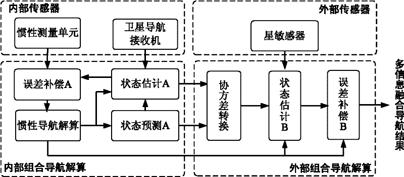
[0044] Such as figure 1 As shown, the inertial / satellite / astronomical multi-level embedded integrated navigation system of the present invention is characterized in that it consists of an internal sensor part, an internal integrated navigation calculation part, an external sensor part, and an external integrated navigation calculation part.

[0045] The internal sensor part is composed of an inertial measurement unit and a satellite navigation receiver; the internal integrated navigation solution part is composed of an inertial navigation solution module, an error compensation A module, a state prediction A module, and a state estimation A module; the external The sensor part is composed of a star sensor; the external integrated navigation solution part is composed of a covariance conversion module, a state estimation B module, and an error compensation B modu...


PUM


Abstract

The invention discloses a multi-level embedded integrated navigation system and a navigation method, belonging to the technical field of integrated navigation. The method comprises the following steps: firstly establishing an aviation airborne inertial navigation system (INS) error state value equation and an inertia/satellite integrated measurement model, then defining a navigation error state value of an embedded inertia/satellite integrated system and establishing an inertia/star sensor integrated measurement model; on that basis, carrying out embedded inertia/satellite integrated system internal integrated navigation resolving and close-loop filtering correction, and finally carrying out external inertia/star sensor integrated navigation resolving and open-loop filtering correction to obtain multi-information fusion navigation results. According to the invention, the complete independent integrated structure of the embedded inertia/satellite integrated system can be kept, and simultaneously the multi-level fusion of inertia/satellite/astronomy asynchronous multi-sensor information and the step-by-step correction of the inertial navigation system are realized, the integrated navigation performance is effectively raised, and the invention is suitable for engineering application.

Description

technical field [0001] The invention discloses a multi-level embedded combined navigation system and a navigation method, belonging to the technical field of combined navigation. Background technique [0002] In recent years, the embedded inertial / satellite integrated navigation system engineering products composed of inertial navigation system, satellite navigation receiver and Kalman filter computing unit have become increasingly mature, and have been widely used in airborne and missile-borne environments. The inertial / satellite integrated navigation system estimates and corrects the inertial navigation error online through a filtering algorithm based on the position and speed measurement information of the satellite navigation receiver, and can obtain high position and speed measurement accuracy; in the absence of direct measurement of the carrier attitude Under such circumstances, the inertial / satellite integrated navigation system can only correct the gyro drift through...

Claims


Application Information

Patent Timeline
IPC IPC(8): G01C21/24
Inventor 王融熊智刘建业陈计辉曾庆化张丹张旭张承彭惠吴旋
Owner NANJING UNIV OF AERONAUTICS & ASTRONAUTICS
Why Eureka
Try Eureka