Method for extracting point cloud data of tree height based on space three-dimensional template

A 3D template, point cloud data technology, applied in image data processing, image analysis, instruments, etc., to avoid adverse effects and ensure reliability

Inactive Publication Date: 2012-06-27
WUHAN UNIV
View PDF3 Cites 20 Cited by
  • Summary
  • Abstract
  • Description
  • Claims
  • Application Information

AI Technical Summary

Problems solved by technology

[0007]The method of directly calculating tree height based on point cloud 3D information is more common in practice, but the problem is that the extraction accuracy is low, and it cannot be adjusted according to the characteristics of forest tree types However, the ground 3D scanning equipment is expensive and generates a large amount of data, which is not suitable for large-scale applications and Rapid processing of information; methods based on other tree information need to adjust inversion parameters and models according to regional differences, and often need to count a large number of measured samples, so they are not universally applicable

Method used


Image

  • Method for extracting point cloud data of tree height based on space three-dimensional template
  • Method for extracting point cloud data of tree height based on space three-dimensional template
  • Method for extracting point cloud data of tree height based on space three-dimensional template

Examples


Embodiment Construction

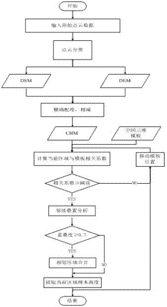
[0026] Point cloud classification is a conventional method in the field of lidar processing, and the specific classification process will not be repeated.

[0027] Step b, respectively generate the digital elevation model (DEM) and digital surface model (DSM) of the area to be extracted, where the digital elevation model is generated by interpolating the ground point cloud data obtained in step a, and the digital surface model The generation method is obtained by interpolating the non-noise point cloud data obtained in step a.

[0028] The DEM generation algorithm of the embodiment is divided into three steps: the first step is to rasterize the point cloud data, and for the situation that multiple points appear in the grid unit, use the minimum elevation value as the grid unit value; the second step is The local minimum search window algorithm is used to extract the ground points; the third step is to use the irregular triangulation interpolation algorithm to interpolate the g...


PUM


Abstract

The invention relates to a method for extracting point cloud data of tree height based on a space three-dimensional template, which comprises the following steps: classifying original point cloud data to generate a digital elevation model (DEM), a digital surface model (DSM) and a tree canopy model (CHM) of a domain to be extracted; respectively computing the related coefficients of subdomains ofthe CHM and the template by introducing the space three-dimensional template; then marking the subdomains meeting requirements by utilizing a threshold distinguishing method; and finally performing adjacent superposition analysis in the marked candidate domain and merging the adjacent domains with over-high overlapping degree to generate tree height information. When ensuring the extracting precision of tree heights, the method effectively solves the problem of tree height judgment ambiguity of adjacent domains so that the extracted tree height information has higher quality and larger practical value, wherein the problem of tree height judgment ambiguity is caused by the phenomenon of tree superposition.

Description

technical field [0001] The invention belongs to the field of spatial information processing, and relates to a tree height extraction method of point cloud data based on a spatial three-dimensional template. Background technique [0002] Forest is the most widely distributed and richest ecosystem on land, and it has a very important impact on regulating the ecological balance and the living environment of human beings. The traditional forest tree height measurement requires field measurement and can only obtain data at some points, which is not only time-consuming and laborious, but also often fails to meet the required accuracy requirements. The rapid development of LiDAR technology in recent years can provide accurate three-dimensional spatial information. Its multiple echo characteristics can not only obtain point cloud information on the upper surface of forest trees, but also partially penetrate the forest surface to obtain the vertical structure of tree canopy. infor...

Claims


Application Information

Patent Timeline
Patent Type & Authority Applications(China)
IPC IPC(8): G06T7/00
Inventor 邵振峰刘冲刘军
Owner WUHAN UNIV
Why Eureka
Try Eureka