Method for detecting landslip from remotely sensed image by adopting image classification technology

A technology of remote sensing image and classification technology, which is applied in the direction of instruments, character and pattern recognition, computer components, etc., and can solve the problem of low overall detection rate

Active Publication Date: 2012-07-04
海安华达石油仪器有限公司 +1
View PDF2 Cites 22 Cited by
  • Summary
  • Abstract
  • Description
  • Claims
  • Application Information

AI Technical Summary

Problems solved by technology

However, the object-based high-resolution remote sensing image landslide detection method requires multi-scale and multi-level segmentation of multi-period remote sensing images, and the detection effect directly depends on the results of image segmentation, and the overall detection rate is n...

Method used


Image

  • Method for detecting landslip from remotely sensed image by adopting image classification technology
  • Method for detecting landslip from remotely sensed image by adopting image classification technology
  • Method for detecting landslip from remotely sensed image by adopting image classification technology

Examples


Embodiment Construction

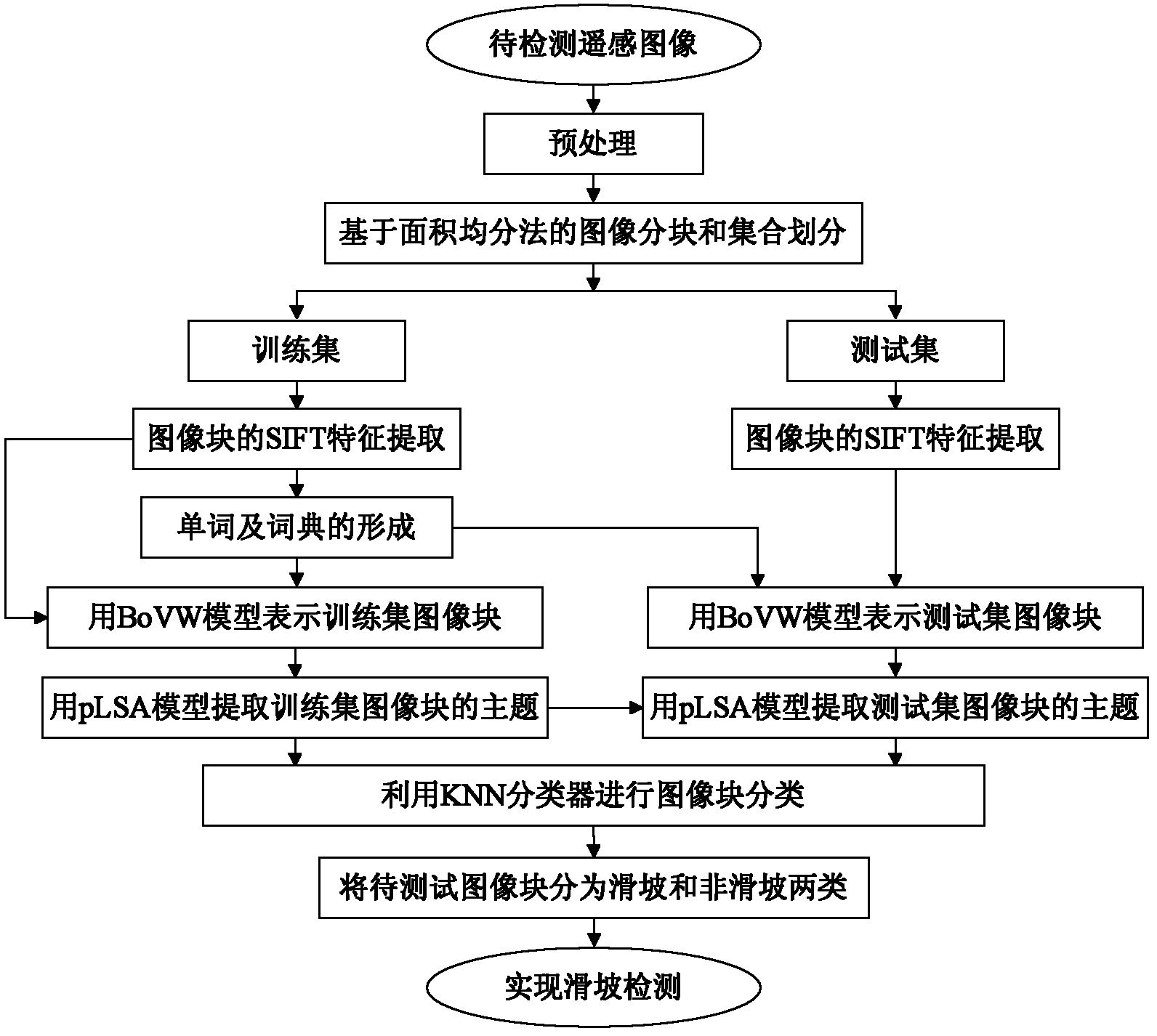
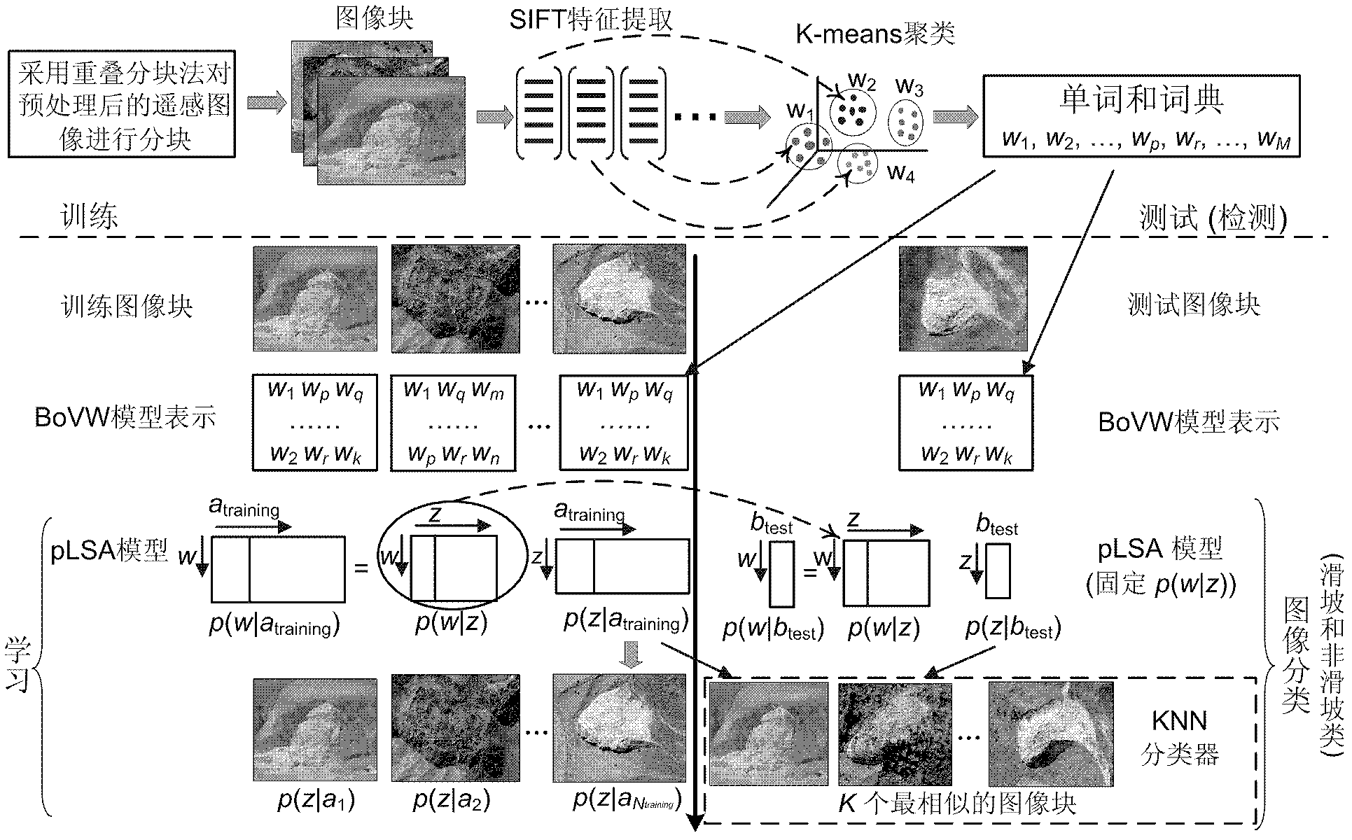
[0042] Now in conjunction with embodiment, accompanying drawing, the present invention will be further described:

[0043] The hardware environment used for implementation is: Intel(R) Core(TM) i5 CPU 3.2G computer, 2GB memory, 1G graphics card, and the running software environment is: Matlab R2008a and Windows XP. We have realized the method that the present invention proposes with Matlab software. The remote sensing images used in this experiment were taken from the three hardest-hit areas of landslides in Gongliu County and Xinyuan County of Yili Autonomous Prefecture, Xinjiang. The specific geographical coordinates are: 82°32′41″-82°39′33″ east longitude, 43 north latitude °06′13″-43°12′02″; East Longitude 82°44′00″-83°10′50″E, North Latitude 43°08′57″-43°14′21″; East Longitude 83°17′41 ″-83°35′15″, 43°12′02″-43°31′32″ north latitude.

[0044] The present invention is specifically implemented as follows:

[0045] 1. Preprocessing: Use the weighted average method to weig...


PUM


Abstract

The invention relates to a method for detecting a landslip from a remotely sensed image by adopting an image classification technology. The method comprises the following steps: firstly, partitioning the remotely sensed image after being pretreated according to an overlapping-based area averaging method, thereby obtaining square image blocks with the same areas; dividing the obtained image blocksinto two sets: a training set and a test set; extracting SIFT (Scale Invariant Feature Transform) features of all the image blocks in the training set and the test set; processing the SIFT features in the training set according to a k-means classifying method, thereby obtaining words and a dictionary; representing each image block in the training set and the test set by a BoVW model; and lastly, utilizing a pLSA model to extract the theme of each image block, and utilizing a KNN classifier to divide the image blocks in the test set into landslip type and non-landslip type image blocks, thereby realizing the landslip detection for the remotely sensed image. The method provided by the invention has the advantages of small calculation volume, high detecting efficiency and ultrahigh detectingaccuracy.

Description

technical field [0001] The invention relates to a method for detecting landslides from remote sensing images by using image classification technology, which can be applied to landslide detection of various remote sensing images. Background technique [0002] Landslides are a kind of extremely destructive geological disasters, which often cause huge losses to industrial and agricultural production as well as people's lives and property. Therefore, landslide research has been paid more and more attention by people. Early landslide detection mainly used the traditional ground survey method, which is very intensive in field work, especially in dangerous and harsh climate areas, and the work efficiency is very low. By the end of the 1990s, the interpretation of stereoscopic aerial photos combined with certain ground verification became the most commonly used method for landslide detection and mapping, and then the interpretation results were manually transferred to topographic m...

Claims


Application Information

Patent Timeline
IPC IPC(8): G06K9/62
Inventor 郭雷程塨韩军伟任波赵天云钱晓亮余博
Owner 海安华达石油仪器有限公司
Why Eureka
Try Eureka