
Method and system for starting navigation system

A navigation system and satellite technology, applied in the field of navigation, can solve problems such as long time consumption and complex hot start method, and achieve the effect of shortening the start time

Inactive Publication Date: 2012-07-11
ANYKA (GUANGZHOU) MICROELECTRONICS TECH CO LTD
View PDF4 Cites 10 Cited by
  • Summary
  • Abstract
  • Description
  • Claims
  • Application Information

AI Technical Summary

Problems solved by technology

[0010] The purpose of the embodiments of the present invention is to provide a navigation system startup method, aiming to solve the problem that the hot startup method of the navigation system provided by the prior art is complicated to implement, takes a long time, and requires a high-precision GPS receiver to be installed. Problems with RTCs

Method used


Image

  • Method and system for starting navigation system
  • Method and system for starting navigation system
  • Method and system for starting navigation system

Examples


Embodiment Construction

[0029] In order to make the object, technical solution and advantages of the present invention clearer, the present invention will be further described in detail below in conjunction with the accompanying drawings and embodiments. It should be understood that the specific embodiments described here are only used to explain the present invention, not to limit the present invention.

[0030] In the embodiment of the present invention, the starting method of the navigation system proposed by the embodiment of the present invention does not need to complete the frame synchronization of the GPS navigation data, and does not depend on whether a high-precision RTC is installed in the GPS receiver. It takes less time and can be realized at a lower cost.

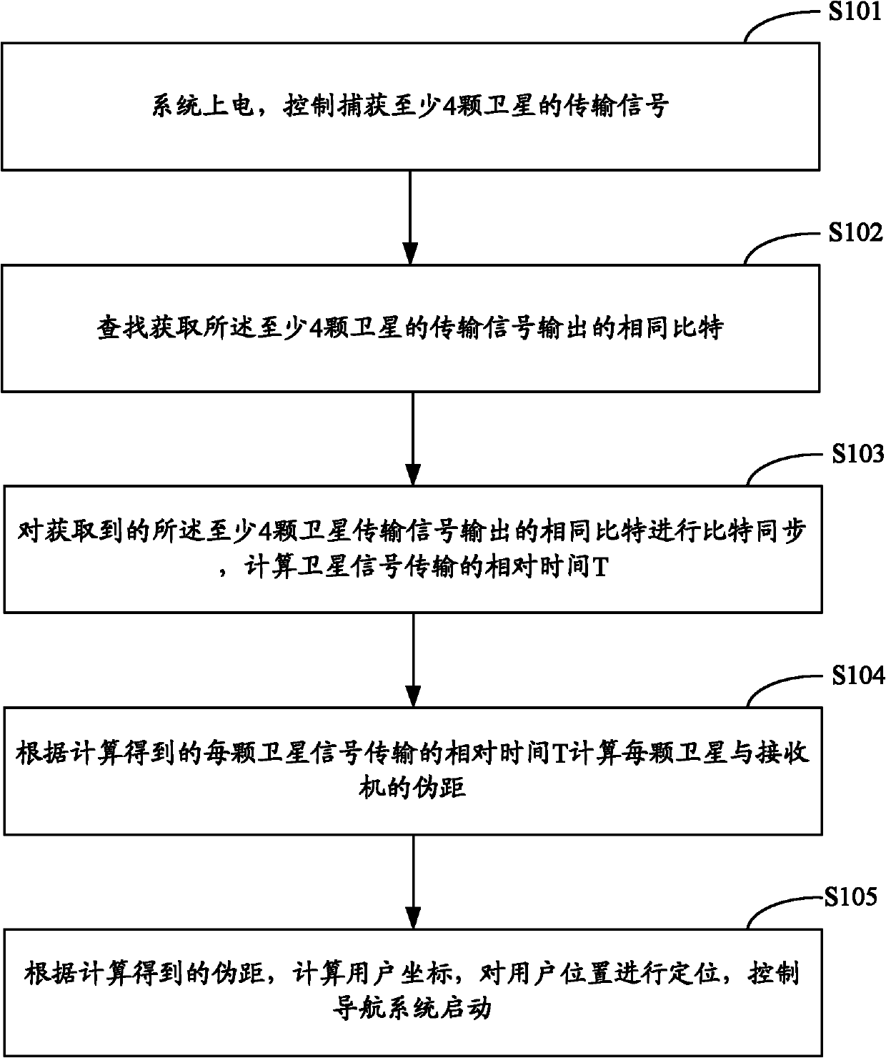
[0031] The purpose of the embodiments of the present invention is to provide a method for starting a navigation system, the method including the following steps:

[0032] Power on the system to control and capture the transmission s...


PUM


Abstract

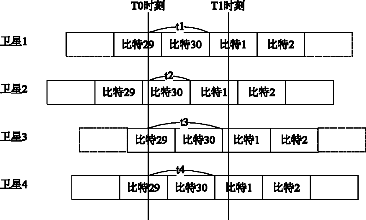
The invention is suitable for the technical field of multi-media data processing and provides a method and system for starting a navigation system. The method comprises the following steps: capturing transmission signals of at least four satellites under control; finding to acquire same bits output by the transmission signals of at least four satellites; performing bit synchronization on the same bits, and computing the relative time T of transmission; computing pseudorange rho from each satellite to a receiver according to the worked-out relative time T of the signal transmission of each satellite; computing user coordinates according to the worked-out pseudorange rho; positioning the position of a user; and controlling the navigation system to be started. In the embodiment of the invention, the bit synchronization is performed on the same bits in the captured transmission signals of the satellites, and the relative time T of the signal transmission of the satellites is computed; the pseudorange rho from each satellite to the receiver is computed; the user coordinates are computed according to the worked-out pseudorange rho; the position of the user is positioned; and the navigation system is controlled to be started, thereby, the starting time is shortened, and meanwhile, the hardware cost does not need to be additionally increased.

Description

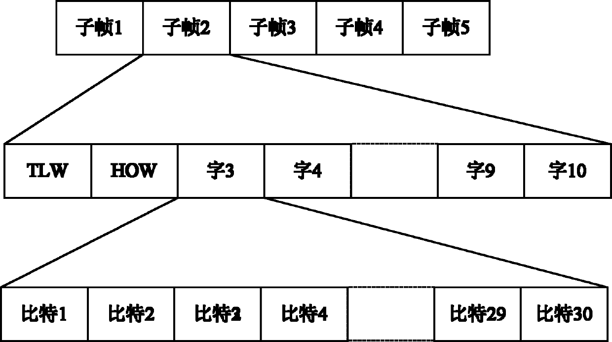
technical field [0001] The invention belongs to the technical field of navigation, and in particular relates to a method and system for starting a navigation system. Background technique [0002] After about 30 years of gradual development, the Global Positioning System (G1obal Positioning System, GPS) has become a complete all-weather, high-precision radio positioning and timing system facing the world, and has won the trust of the majority of users. GPS was originally used mainly in the military, and its role in the civilian field has greatly expanded with the cancellation of the Selective Availability (SA) policy. In terms of performance, satellite navigation user products are developing in the direction of fast positioning, high sensitivity, high precision, miniaturization, low power consumption, and integrated navigation. The rapid positioning capability of the navigation receiver is mainly determined by the Time To First Fix (TTFF) index. To improve the performance of...

Claims


Application Information

Patent Timeline
Patent Type & Authority Applications(China)
IPC IPC(8): G01S19/24
Inventor 舒洋胡胜发
Owner ANYKA (GUANGZHOU) MICROELECTRONICS TECH CO LTD
Learn More