Eureka AIR delivers breakthrough ideas for toughest innovation challenges, trusted by R&D personnel around the world.

Processing method and processing device of remote sensing image data

A technology of remote sensing image and processing device, applied in the field of remote sensing, can solve the problems of difficult object identification, no effective solution is proposed, limited application of remote sensing image data, etc., so as to restore the texture of objects and remove shadows.

Active Publication Date: 2012-07-18
CHINA SHENHUA ENERGY CO LTD +1
View PDF4 Cites 1 Cited by
  • Summary
  • Abstract
  • Description
  • Claims
  • Application Information

AI Technical Summary

Problems solved by technology

[0002] At present, the remote sensing image data obtained through satellite remote sensing and aerial remote sensing platforms are affected by the height of ground objects, especially in high mountain areas, which often cause shadow areas to varying degrees due to terrain effects. The real landform characteristics in the shadow areas are completely or Partially covered, it is difficult to distinguish ground objects, which limits the application of remote sensing image data
[0003] For the above problems, no effective solution has been proposed in the related art

Method used


Image

  • Processing method and processing device of remote sensing image data
  • Processing method and processing device of remote sensing image data
  • Processing method and processing device of remote sensing image data

Examples


Embodiment Construction

[0021] It should be noted that, in the case of no conflict, the embodiments in the present application and the features in the embodiments can be combined with each other. The present invention will be described in detail below with reference to the accompanying drawings and examples.

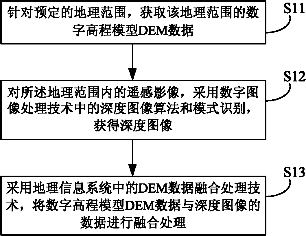
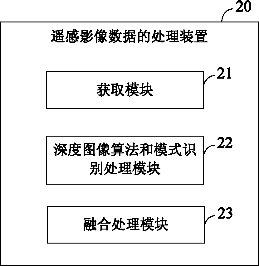
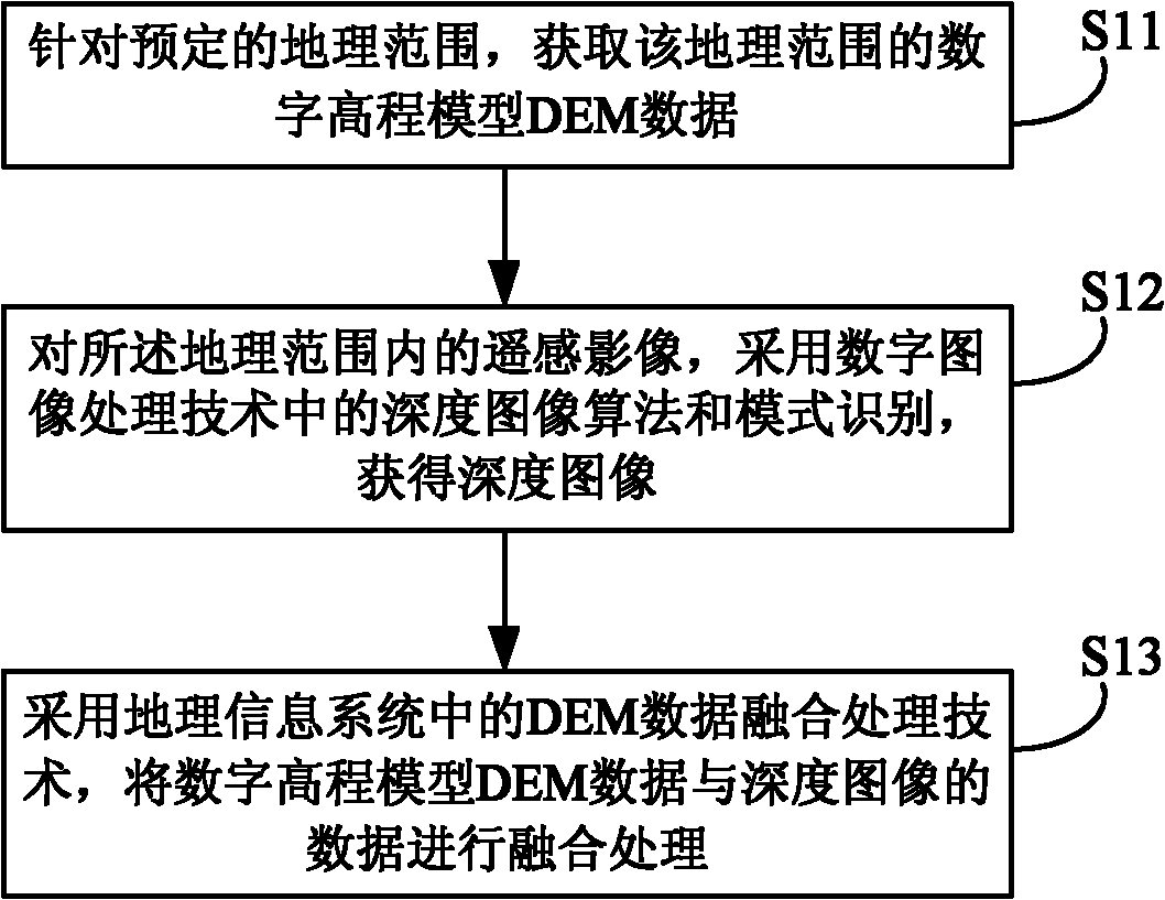
[0022] figure 1 is a schematic diagram of the basic steps of the remote sensing image data processing method according to the embodiment of the present invention. Such as figure 1 As shown, the method mainly includes the following steps:

[0023] Step S11: For a predetermined geographic range, acquire digital elevation model DEM data of the geographic range.

[0024] Step S12: For the remote sensing image within the geographical range, adopt the depth image algorithm and pattern recognition in the digital image processing technology to obtain the depth image;

[0025] Step S13: Using the DEM data fusion processing technology in the geographic information system, the digital elevation model ...


PUM


Abstract

The invention provides a processing method and processing device of remote sensing image data, which are used for solving problems that it is difficult to distinguish ground objects because real geomorphic characteristics in a shadow region are completely or partially shielded during imaging in the prior art. The method comprises the following steps of: for a preset geographic range, obtaining digital elevation model (DEM) data within a geographic range; obtaining a depth image from remote sensing images within the geographic range by using depth image algorithm and mode identification in the digital image processing technology; and fusing the DEM data and the depth image data by using a DEM data fusion processing technology in a geographic information system. By using the technical scheme provided by the invention, the shadow can be eliminated in a comparatively effective way so that contribution is made to really recovering ground object texture so as to distinguish the ground objects.

Description

technical field [0001] The invention relates to the technical field of remote sensing, in particular to a processing method and device for remote sensing image data. Background technique [0002] At present, the remote sensing image data obtained through satellite remote sensing and aerial remote sensing platforms are affected by the height of ground objects, especially in high mountain areas, which often cause shadow areas to varying degrees due to terrain effects. The real landform characteristics in the shadow areas are completely or Partially covered, it is difficult to distinguish ground objects, which limits the application of remote sensing image data. [0003] For the above problems, no effective solution has been proposed in the related art. Contents of the invention [0004] The main purpose of the present invention is to provide a processing method and device for remote sensing image data, which help to distinguish ground objects in shadow areas in remote sensi...

Claims


Application Information

Patent Timeline
Patent Type & Authority Applications(China)
IPC IPC(8): G06T17/05
Inventor 周正武
Owner CHINA SHENHUA ENERGY CO LTD
Why Eureka
Eureka Blog
Learn More