Remote sensing image atmospheric correction method

A technology for atmospheric correction and remote sensing images, applied in the field of remote sensing, can solve problems such as unavailability, unsatisfactory inversion results, and inability to obtain dense vegetation surface reflectance, etc., to achieve the effect of improving the accuracy of correction

Active Publication Date: 2012-08-08
AEROSPACE INFORMATION RES INST CAS
View PDF1 Cites 33 Cited by
  • Summary
  • Abstract
  • Description
  • Claims
  • Application Information

AI Technical Summary

Problems solved by technology

In 2007, the MODIS algorithm (C5) corrected the relationship between the surface reflectance of visible light and near-infrared bands, and after using more diverse and more accurate aerosol models on a global scale (based on the global aerosol ground-based observation network AERONET ), the inversion accuracy has been greatly improved compared with the previous C4 version (see the figure below), but the inversion results of the upgraded algorithm in some urban areas are not satisfactory
Moreover, even though the dense vegetation algorithm is feasible in urban areas, since the CCD camera of the Environment-1 satellite does not have a mid-infrared band, the surface reflectance of dense vegetation cannot be obtained, so this algorithm cannot be used for the Environment-1 satellite

Method used


Image

  • Remote sensing image atmospheric correction method
  • Remote sensing image atmospheric correction method
  • Remote sensing image atmospheric correction method

Examples


Embodiment Construction

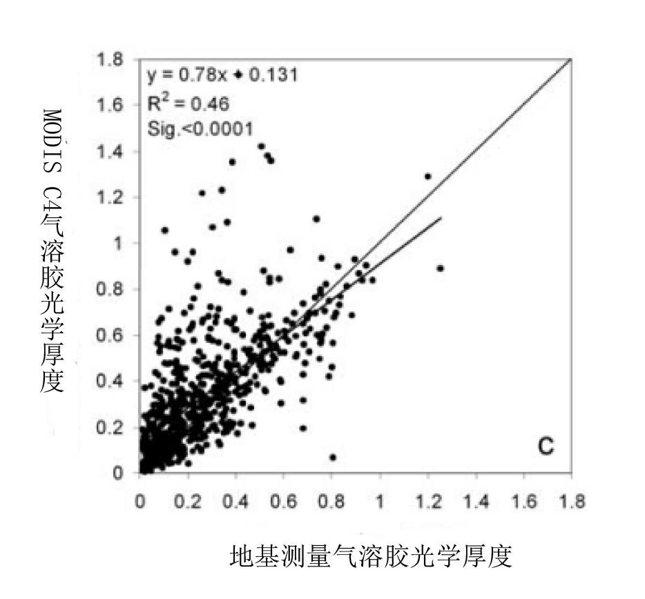
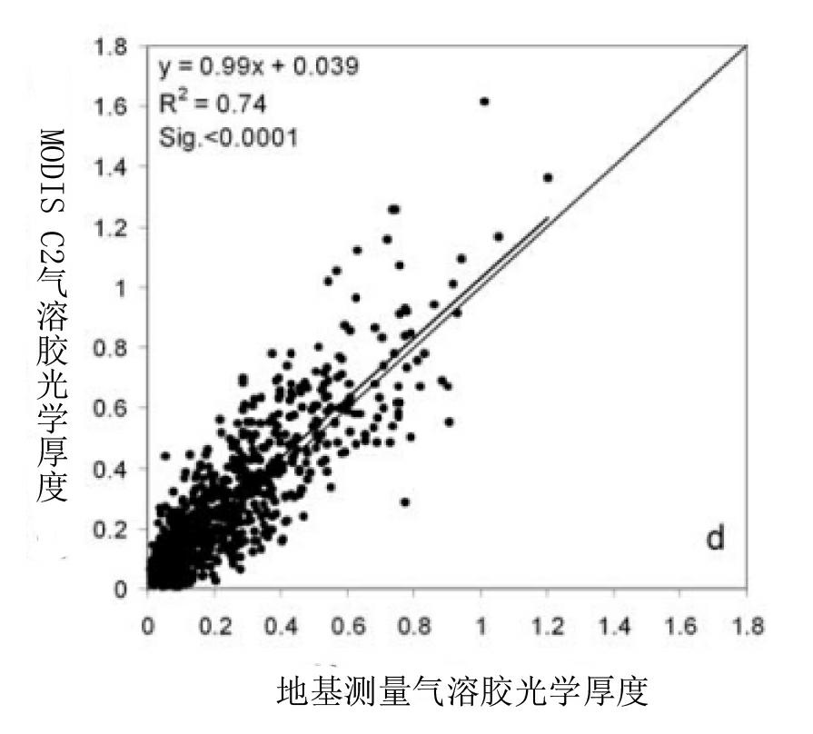
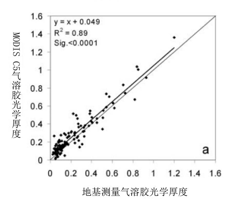
[0034] Compared with the existing aerosol retrieval sensors, the CCD camera of the Environment-1 satellite has a very high spatial resolution (30 meters), so that compared with dense vegetation pixels, more pure vegetation can be found on the image. Pixels, these pure pixels may contain vegetation, but also include large squares in the city (such as Tiananmen Square in Beijing), roofs, roads, and lakes, and these latter pure pixels also exist in winter. Another advantage of the CCD camera of the Environment-1 satellite is its high time resolution, especially when A star and B star are combined, this advantage is more obvious. Therefore, a series of observations can be obtained for the same target within a certain period of time, including observations of sunny weather and observations of polluted weather. There are a variety of aerosol optical depth inversion algorithms that assume that the surface reflectance changes little within a certain period of time (such as within thre...


PUM


Abstract

The invention discloses a remote sensing image atmospheric correction method which comprises the following specific steps of: 1) constructing a look-up table; 2) calculating the apparent reflectance; 3) acquiring angle information; 4) acquiring the optical thickness of aerosol: obtaining the optical thickness of aerosol by utilizing HJ--1 satellite CCD (Charged Coupled Device) data inversion based on a pure pixel method; 5) obtaining atmospheric correction parameters by utilizing pixel imaging geometry and optical thickness interpolation; and 6) carrying out atmospheric correction on pixels one by one, so as to obtain the reflectance ratio of the ground surface. Compared with a dark pixel method, the remote sensing image atmospheric correction method has the advantages that the obtained reflectance ratio is more approximate to the actually measured reflectance ratio of the ground surface, and the correction accuracy is greatly improved.

Description

technical field [0001] The invention relates to the field of remote sensing, in particular to a method for correcting the atmosphere of remote sensing images. Background technique [0002] In order to reduce the influence of atmospheric blur effect on satellite remote sensing images and improve the application ability of satellite remote sensing data, people have carried out extensive research on atmospheric correction of remote sensing data. The earliest research began in the 1970s. After years of development, many Atmospheric correction methods can be roughly classified into two types: the correction method based on the image itself and the correction method based on the atmospheric radiative transfer model. [0003] Atmospheric correction methods based on image features require known or assumed albedo values ​​of certain pixels in the image to establish the relationship between surface albedo and satellite observations, and assume that the entire image has the same atmosp...

Claims


Application Information

Patent Timeline
Patent Type & Authority Applications(China)
IPC IPC(8): G01S7/497
Inventor 顾行发余涛方莉李家国高海亮赵利民
Owner AEROSPACE INFORMATION RES INST CAS
Why Eureka
Try Eureka