Soil-sampling method based on high-resolution satellite remote sensing data

A technology for satellite remote sensing data and high-resolution satellites, which is applied in sampling devices and other directions to achieve the effect of improving rationality and representativeness and saving sampling costs.

Active Publication Date: 2012-08-22
ZHEJIANG UNIV
View PDF5 Cites 25 Cited by
  • Summary
  • Abstract
  • Description
  • Claims
  • Application Information

AI Technical Summary

Problems solved by technology

However, the research on soil sampling methods using the variance quadtree method with the help of high-resolu

Method used


Image

  • Soil-sampling method based on high-resolution satellite remote sensing data
  • Soil-sampling method based on high-resolution satellite remote sensing data
  • Soil-sampling method based on high-resolution satellite remote sensing data

Examples


Embodiment Construction

[0020] The present invention will be further described below in conjunction with drawings and embodiments.

[0021] The tidal flat experimental farm in the northwest area of ​​Shangyu City, Zhejiang Province and the south bank of Hangzhou Bay was selected as the research area. The ALOS / PALSAR high-resolution radar remote sensing data (spatial resolution 12.5 meters) that passed through the border on November 21, 2011 was selected for backscatter coefficient extraction.

[0022] (1) Preprocessing of high-resolution satellite remote sensing data: backscatter coefficient σ of ALOS / PALSAR L-band HH polarization images 0 (dB) is obtained by the pixel DN value of the image by formula (1), and the backscatter coefficient raster image data is stored in the form of a file;

[0023] σ 0 =10*log 10 (DN) 2 +ε (1)

[0024] In the formula, ε is the radar calibration coefficient, and for ALOS / PALSAR Level 1.5 data ε=-83.0.

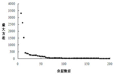
[0025] (2) Divide the area layer: place the extracted radar b...


PUM


Abstract

The invention discloses a soil-sampling method based on high-resolution satellite remote sensing data. The high-resolution satellite remote sensing image of a researched region is acquired, and the raster data of related indexes is calculated. The data is put into a rectangular frame, and is then divided into four zones with equal area, the semivariance mean of each zone is calculated, the zone with the maximum semivariance mean is found out and continuously divided into four zones, the maximum semivariance mean is rapidly reduced as the frequency of iteration is increased, and the amplitude of reduction is gradually decreased until a certain given iteration frequency or the maximum semivariance mean is less than a given threshold value (corresponding to a sampling error limit). Finally, the sampled region is divided into a large number of zones, the areas of which are different but the attribute differences of which are relatively uniform, and each zone is a soil-sampling unit. The method which integrates high-resolution satellite remote sensing data with the variance quad-tree method to sample soil can be utilized to rapidly and accurately acquire an optimal soil-sampling layout scheme, so the sampling cost is saved and the rationality and typicality of sampling points are increased.

Description

technical field [0001] The invention relates to a soil sampling method, in particular to a soil sampling method based on high-resolution satellite remote sensing data. Background technique [0002] Reasonable soil sampling methods are the basis for scientific soil management and rational fertilization, and are the prerequisite for the implementation of precision agriculture. It is the purpose of soil sampling to achieve the maximum prediction accuracy with the minimum number of samples. The spatial variability of soil properties can be predicted from the collected sample information to unsampled points. The reliability of this prediction depends on whether the initial sampling is representative and whether it effectively describes the variability of the field. Whether the soil sampling method is reasonable or not is directly related to the expression of spatial variation characteristics. Common soil sampling methods can be classified into two categories: classical statisti...

Claims


Application Information

Patent Timeline
IPC IPC(8): G01N1/04
Inventor 史舟郭燕周银周炼清
Owner ZHEJIANG UNIV
Why Eureka
Try Eureka