Remote visualization method for ocean current vector fields

A vector field and ocean current technology, which is applied in the field of real-time generation of ocean current vector field visualization, can solve the problem that the spatial data sharing method cannot meet the user's requirements for the visualization and sharing of marine environmental information, and achieve the effect of improving the inconsistency of the format and improving the efficiency of use

Inactive Publication Date: 2012-08-22
INST OF GEOGRAPHICAL SCI & NATURAL RESOURCE RES CAS
View PDF2 Cites 9 Cited by
  • Summary
  • Abstract
  • Description
  • Claims
  • Application Information

AI Technical Summary

Problems solved by technology

Due to the distribution, dynamics, heterogeneity and abstraction of marine vector field data, traditional spatial data sharing methods cannot meet users' requirements for real-time dynamic visualization and sharing of marine environmental information

Method used


Image

  • Remote visualization method for ocean current vector fields
  • Remote visualization method for ocean current vector fields
  • Remote visualization method for ocean current vector fields

Examples


Embodiment Construction

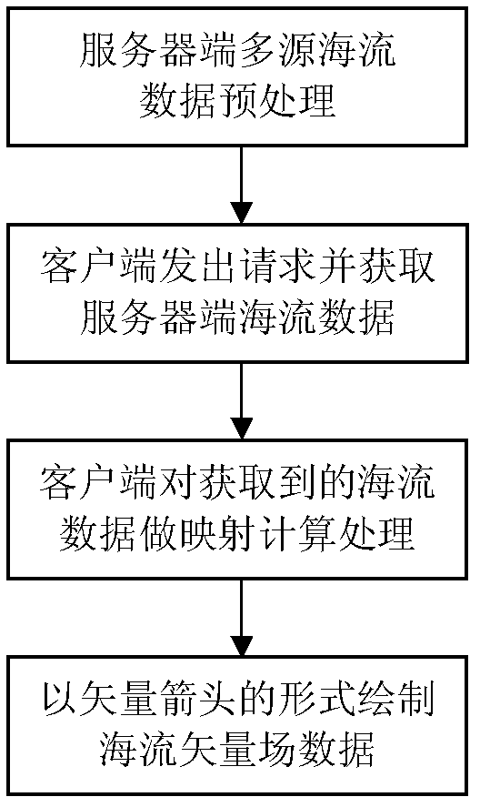
[0016] In order to better realize the above-mentioned purpose of the invention, the following will combine figure 1 The block diagram further describes each step in the present invention:

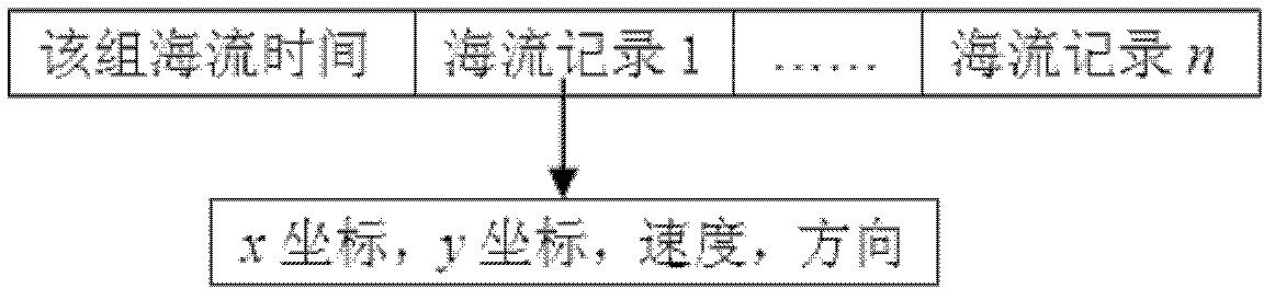
[0017] In step 1, when recording the ocean current vector field data, the traditional method is to represent the ocean current velocity (including magnitude and flow direction) with its components u and v and store them in two data files respectively. The structure of the ocean current cannot be obtained intuitively in field analysis. For this reason, the present invention adopts such as figure 2 The data structure shown stores ocean current vector field data. By recording the x-coordinate and y-coordinate of the ocean current at a certain point, its spatial coordinate position is marked, and the velocity, direction and time of the ocean current at this point are used to record the properties of the ocean current. The multi-source ocean current data files can be uploaded and stored on t...


PUM


Abstract

The invention relates to a remote visualization method for ocean current vector fields. By utilizing the method, an effect of carrying out remote acquisition on data of ocean current element fields is achieved through the Internet, and the ocean current vector fields are generated in real time, thereby realizing the network remote real-time visualization of the ocean current vector fields in multi-source, heterogeneous and distributed environments. The method disclosed by the invention comprises the following steps: firstly, preprocessing ocean current data of a server; then, requesting and receiving the ocean current data of the server by a client; carrying out mapping calculation processing on the obtained ocean current data by the client; and finally, drawing an ocean current vector field in a vector arrow form at the client. The method disclosed by the invention has important guiding significance in studying the flow direction of an ocean current and the dynamic evolution process thereof by marine workers.

Description

technical field [0001] The invention belongs to the field of data model visualization research in a marine geographic information system (MGIS), and relates to a method for remotely acquiring ocean current element field data through the Internet and generating ocean current vector field visualization in real time. Background technique [0002] The research and application of Geographic Information System (GIS) on land has been perfected day by day, and the proposal and development of Digital Earth has raised the application of GIS to a new height. However, due to the complexity and diversity of marine phenomena, the research and application of GIS in the marine environment is still relatively small. With the rapid development of ocean observation technology, the ocean data obtained by marine scientific research and staff are also increasing geometrically. If GIS technology can be used to process marine data, extract useful information, and reveal and re-understand marine ph...

Claims


Application Information

Patent Timeline
Patent Type & Authority Applications(China)
IPC IPC(8): G06F17/30H04L29/08
Inventor 苏奋振吴文周周成虎武芳
Owner INST OF GEOGRAPHICAL SCI & NATURAL RESOURCE RES CAS
Why Eureka
Try Eureka