Sea surface wind measurement method based on X-band marine radar

A measurement method, marine radar technology, applied in the direction of measuring device, fluid velocity measurement, velocity/acceleration/shock measurement, etc.

Active Publication Date: 2012-09-19
哈尔滨哈船导航技术有限公司
View PDF6 Cites 37 Cited by
  • Summary
  • Abstract
  • Description
  • Claims
  • Application Information

AI Technical Summary

Problems solved by technology

[0036] In the above inversion method, due to the strong nonlinearity of the sea clutter image sequen

Method used


Image

  • Sea surface wind measurement method based on X-band marine radar
  • Sea surface wind measurement method based on X-band marine radar
  • Sea surface wind measurement method based on X-band marine radar

Examples


Embodiment Construction

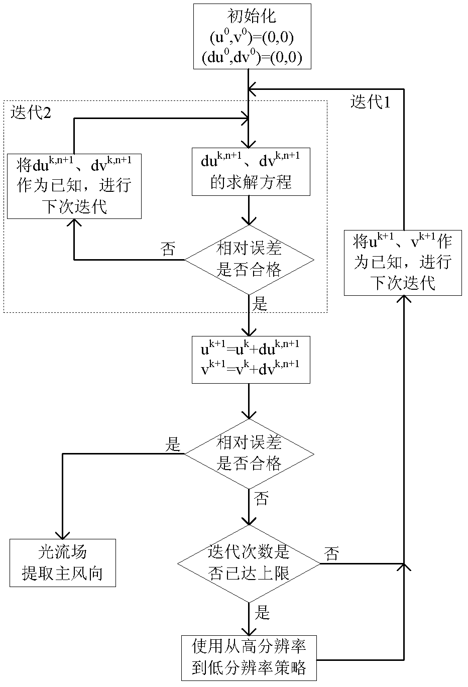
[0123] The sea surface wind field measurement method based on the X-band marine radar provided by the present invention will be introduced in detail below in conjunction with the accompanying drawings.

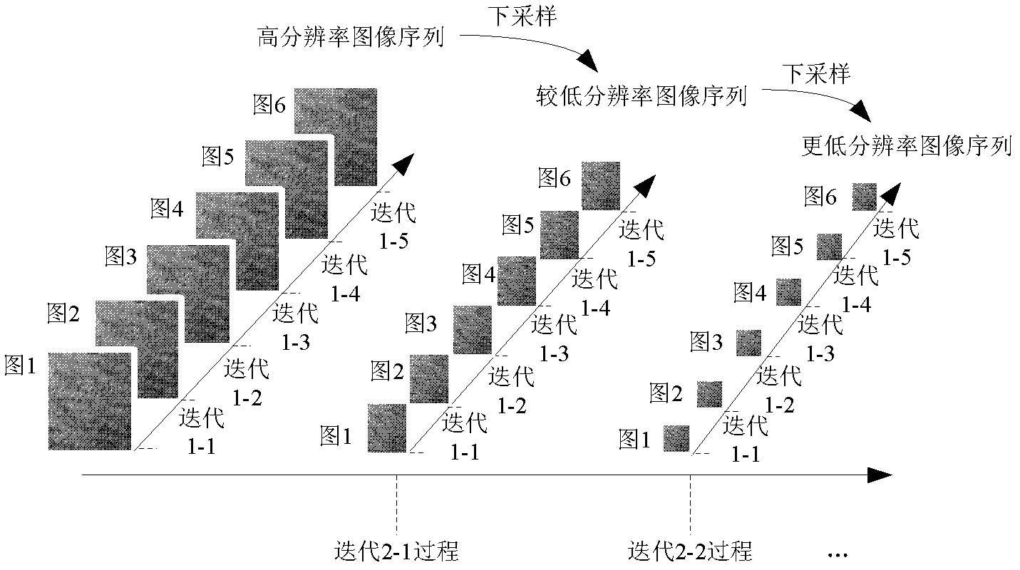
[0124] The sea surface wind field measurement method based on the X-band marine radar provided by the present invention, such as Figure 6 As shown in the flow chart, the sea surface wind field measurement method provided by the present invention includes three parts: pre-processing of radar images, wind direction measurement and wind speed measurement. In the following steps, the first step to the eighth step are pre-processing of radar images, and the ninth step is The first step is to measure the wind direction, and the tenth step is to measure the wind speed. The specific steps are as follows:

[0125] In the first step, the radar image is corrected for azimuth and angle, and a median filter is applied to suppress noise.

[0126] 1.1. Radar image azimuth and angle correct...


PUM


Abstract

The invention discloses a sea surface wind measurement method based on an X-band marine radar and belongs to the technical field of marine dynamic environment remote sensing. The measurement method comprises three parts of radar image preprocessing, wind direction measurement and wind speed measurement. In the wind direction measurement indexes, image gradient, gray level and smoothing item are organically combined, the proportion of the image gradient, the gray level and the smoothing item is adjusted through proportionality factor and a model suitable for the sea surface wind characteristic is established, compared with the prior art, the wind direction measurement precision is improved by 68.4 percent. In the wind speed measurement indexes, when the radar is used for measuring individually, normalized radar cross section (NRCS), the actually measured wind direction and signal to noise ratio (SNR) serve as back propagation (BP) network input, compared with the traditional algorithm, the wind speed measurement precision is improved by over 84 percent. In the wind speed measurement indexes, sea boundary layer parameters serve as addition input of the BP network, so that the wind speed measurement precision of the marine radar can be further improved, and the measurement precision is improved by over 48 percent by taking air-sea temperature difference, salinity, sea level and atmospheric pressure into consideration.

Description

technical field [0001] The invention belongs to the technical field of marine dynamic environment remote sensing, and in particular relates to a method for measuring sea surface wind field parameters by using X-band navigation radar. Background technique [0002] The sea surface wind field is the main source of power for ocean surface activities, regulating the exchange of energy, momentum, matter, and water vapor between the upper and lower atmospheres of the ocean, and directly affecting human sea activities (marine fisheries, sea navigation, ocean engineering, etc.) , which is a key element of the sea / air boundary layer as well as the biosphere system. [0003] When the wind passes over the sea surface, it causes the roughness of the sea surface, that is, micro-scale waves, which are similar to the wavelength of electromagnetic waves of marine radar. When the electromagnetic wave encounters micro-scale waves, Bragg resonance occurs, and backward echoes are generated to fo...

Claims


Application Information

Patent Timeline
IPC IPC(8): G01W1/02G01P5/00G01P13/02
Inventor 刘利强戴运桃贾瑞才卢志忠
Owner 哈尔滨哈船导航技术有限公司
Why Eureka
Try Eureka