Underwater sensor network positioning method

An underwater sensor and network positioning technology, applied in network topology, service based on location information, electrical components, etc., can solve problems such as inability to complete common node positioning and inability to determine the uniqueness of common node coordinates

Inactive Publication Date: 2012-09-26
HOHAI UNIV CHANGZHOU
View PDF2 Cites 27 Cited by
  • Summary
  • Abstract
  • Description
  • Claims
  • Application Information

AI Technical Summary

Problems solved by technology

It can be seen from this that in order to determine the uniqueness of the coordinates of ordinary nodes, the neighbor nodes between the ordinary node and the two-hop reference nodes need to vote for judgment. However, the article does not indicate whether the position of the neighbor node is determined, w

Method used


Image

  • Underwater sensor network positioning method
  • Underwater sensor network positioning method
  • Underwater sensor network positioning method

Examples


Embodiment Construction

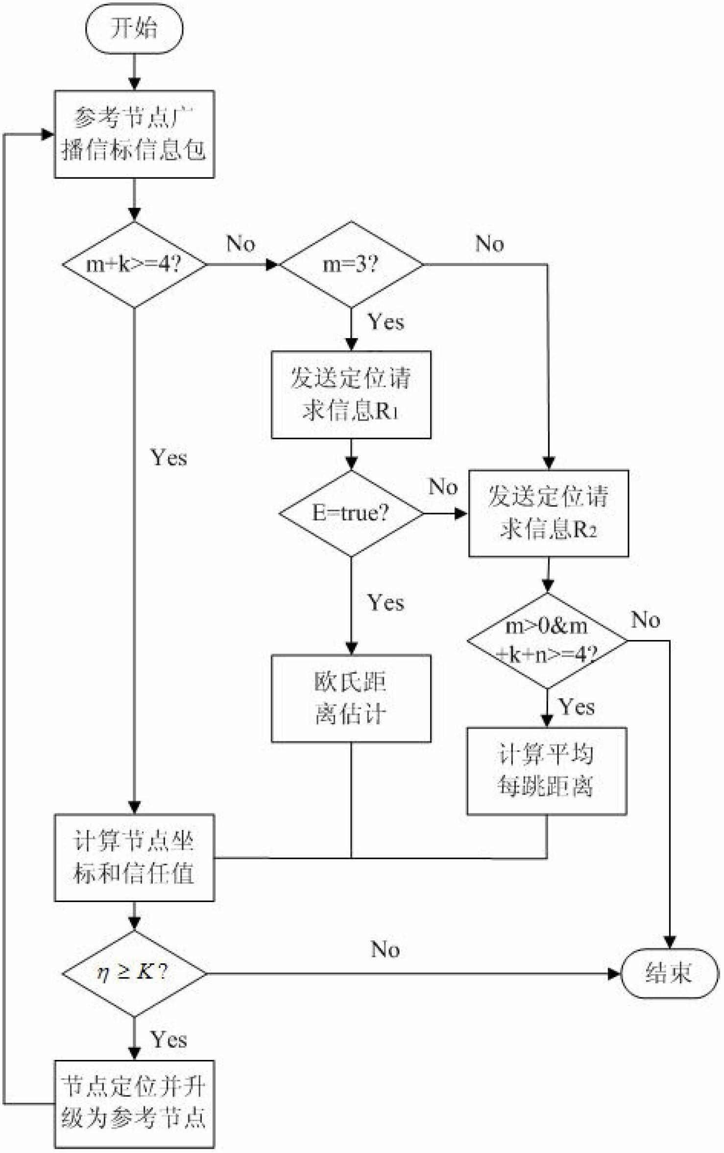
[0057] The present invention will be further described below in conjunction with the accompanying drawings.

[0058] Such as figure 1 Shown is a flow chart of an underwater sensor network positioning method, which specifically includes the following steps:

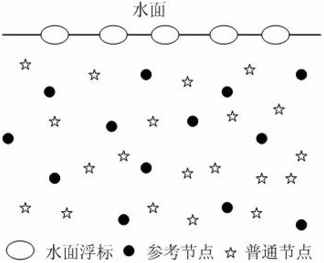
[0059] (1) The reference node and the upgraded reference node periodically broadcast and send beacon information including their own location;

[0060] (2) Ordinary nodes receive the beacon information sent by the reference node and the upgraded reference node. Note that the number of one-hop reference nodes that the ordinary node receives and sends the beacon information is m, and the ordinary node receives the one-hop upgrade reference node that sends the beacon information The number of nodes is k;

[0061] (3) For any common node, when m≥4, calculate the coordinates, positioning error δ and trust value η of the common node according to the quadrilateral measurement method or the maximum likelihood estimation method; ...


PUM


Abstract

The invention discloses an underwater sensor network positioning method, which integrates a three-dimensional Euclidean distance estimation method, an iterative position estimation method and a DV-Hop algorithm, and for completing the positioning of common nodes, gives selection criteria of one-hop upgrade reference nodes, two-hop upgrade reference nodes and next-hop upgrade reference nodes for forwarding positioning request information packets. The method comprises the following steps: calculating the distance between a common node and a two-hop upgrade reference node by using the three-dimensional Euclidean distance estimation method and the DV-Hop algorithm, after the coordinates of the node are calculated by using a four-edge measurement method, calculating a positioning error and a trust value according to the coordinates and the distance between the node and a reference node, comparing the magnitude relation of the trust value and a threshold value, and determining whether the node is positioned successfully and becomes an upgraded reference node; and the iterative position estimation method is used for broadcasting a beacon information packet containing the position of a common node after the common node is positioned successfully, and assisting the positioning of other common nodes. The method disclosed by the invention is applicable to the static or dynamic positioning of nodes in large-scale underwater wireless sensor networks.

Description

technical field [0001] The invention relates to underwater wireless sensor network technology, in particular to a node positioning method in the underwater sensor network. Background technique [0002] Underwater Wireless Sensor Networks (UWSNs for short) is proposed for the application of underwater environment. UWSNs can provide better technical support and information platforms to promote marine environment management, resource protection, disaster monitoring and early warning, marine engineering, offshore production operations, and marine military activities, so underwater wireless sensor networks have broad application prospects. Most applications based on underwater sensor networks are associated with the location of the node. To implement these applications, the node location in the network is required to be uniquely determined. Determining the node location has the following important meanings: First, the data must have location information and time information Mark...

Claims


Application Information

Patent Timeline
IPC IPC(8): H04W4/02H04W64/00H04W84/18
Inventor 韩光洁刘同庆张晨语朱川江金芳郭惠巢佳
Owner HOHAI UNIV CHANGZHOU
Why Eureka
Try Eureka