Method for identifying golf course

A golf course and recognition method technology, applied in character and pattern recognition, instruments, computer parts, etc., can solve problems such as low precision, high cost, and narrow width

Inactive Publication Date: 2012-10-03
INST OF REMOTE SENSING & DIGITAL EARTH CHINESE ACADEMY OF SCI
View PDF1 Cites 15 Cited by
  • Summary
  • Abstract
  • Description
  • Claims
  • Application Information

AI Technical Summary

Problems solved by technology

[0019] The technical problem to be solved by the present invention is to solve the defects of low accuracy of the method for identifying golf courses based on medium-resolution remote sensing images in the prior art, and high cost

Method used


Image

  • Method for identifying golf course
  • Method for identifying golf course
  • Method for identifying golf course

Examples


Embodiment Construction

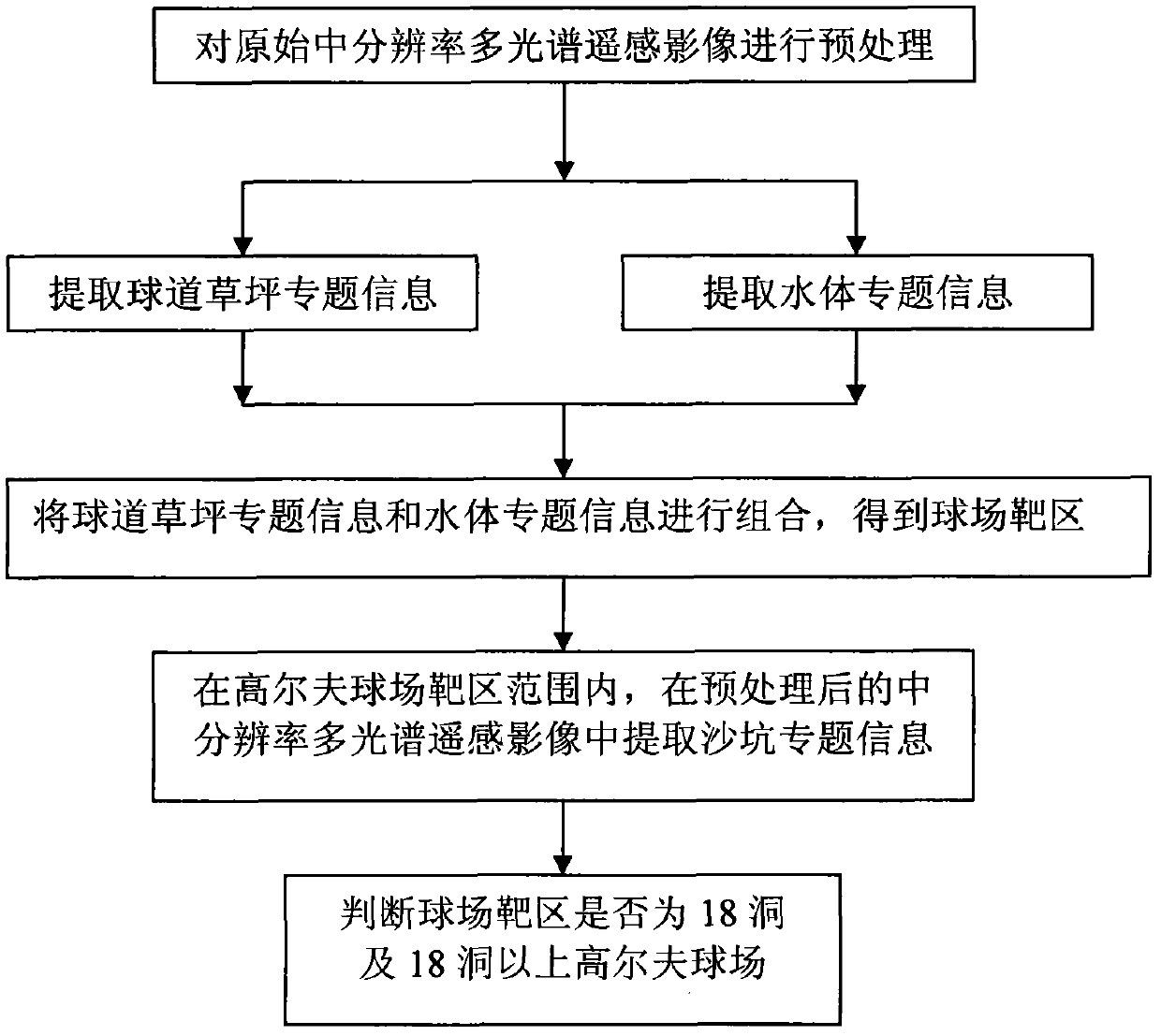
[0147] Below, combine Figure 1 to Figure 7 The method of the present invention is described in further detail:

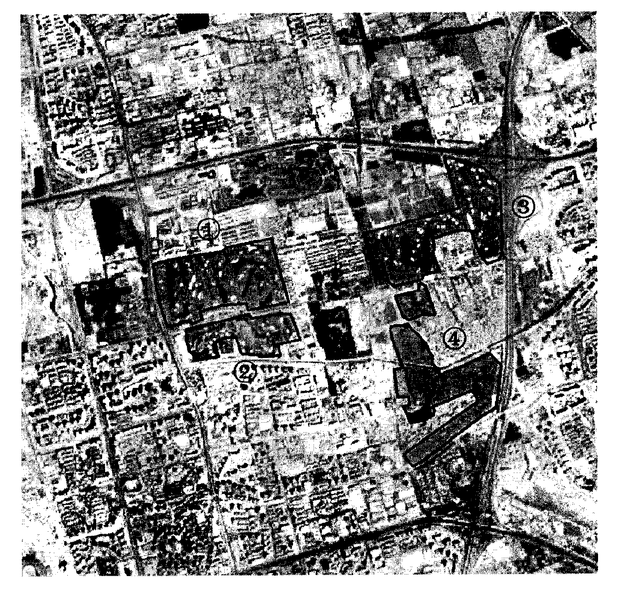
[0148] A sub-picture with a size of 512x512 is intercepted from a scene of SPOT-5HRG L1A multi-spectral image taken on May 17, 2007 in Beijing area as an example data, and the specific implementation manner of the present invention is described.

[0149] Step S1 preprocesses the original medium-resolution multispectral remote sensing image;

[0150] The preprocessing of the original medium-resolution multispectral remote sensing image in this step specifically refers to performing radiation correction and geometric correction on the original medium-resolution multispectral remote sensing image.

[0151] The prerequisites for the preprocessing of the original medium-resolution multispectral remote sensing image are that there are parameters for radiation correction such as sensor calibration coefficient and solar zenith angle, and there are enough ground control po...


PUM


Abstract

The invention solves the problems of low precision of the conventional method for identifying a golf course based on a medium-resolution remote-sensing image and high cost and narrow amplitude of the conventional method for identifying the golf course based on a high-resolution image and a high-spectrum image in the prior art, and provides a method for identifying the golf course based on a medium-resolution multispectral remote-sensing image. The basic concept of the method is that a target region of the golf course is obtained by identifying two basic elements, namely a fairway lawn and a water body, of the golf course according to a space co-occurrence characteristic combination; thematic information of a third basic element, namely a sandpit, in the target region is extracted; and therefore, whether the target region of a ball park is the golf course is judged by taking the single target region as a unit and taking level landscape indexes of the types of the fairway lawn, the water body and the sandpit in the target region and a level landscape index of the landscape of the whole target region of the golf course as distinctive characteristics of the ball park. The method has the advantages of high pertinency, high precision and low cost.

Description

technical field [0001] The invention relates to a golf course recognition method based on medium-resolution multispectral remote sensing images. Background technique [0002] At present, there are few reports on remote sensing target recognition research on golf courses at home and abroad, and the existing related studies have shortcomings such as poor pertinence, low precision, and high cost to varying degrees. The root cause is that these studies do not analyze the characteristics of golf courses The in-depth and insufficient consideration of the accuracy and cost of remote sensing recognition of golf courses can be specifically described as: [0003] 1 Golf course recognition method based on fairway lawn recognition: [0004] Since the fairway lawn is the most important part of the golf course, some studies have simplified the golf course recognition problem into the classification and recognition of the fairway lawn: Frankvich performed principal component analysis and ...

Claims


Application Information

Patent Timeline
IPC IPC(8): G06K9/00G06K9/62
Inventor 陈静波孟瑜刘顺喜
Owner INST OF REMOTE SENSING & DIGITAL EARTH CHINESE ACADEMY OF SCI
Why Eureka
Try Eureka